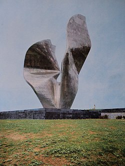
Kamenska | |
|---|---|
Village | |
 | |
| Coordinates: 45°26′39″N 17°28′46″E / 45.44417°N 17.47944°E | |
| Country | |
| Region | Slavonia |
| County | Požega-Slavonia County |
| Municipality | Brestovac |
| Area | |
| • Total | 0.5 km2 (0.2 sq mi) |
| Elevation | 237 m (778 ft) |
| Population (2021)
[2] | |
| • Total | 5 |
| • Density | 10/km2 (26/sq mi) |
| Time zone | UTC+1 ( CET) |
| • Summer ( DST) | UTC+2 ( CEST) |
| Postal codes | 34320 Orljavac |
| Area code | (+385) 34 |
Kamenska is an uninhabited village in Požega-Slavonia County, Croatia. Kamenska is administered as a part of the Brestovac municipality. The village is connected by the D38 state road.
Demographics
According to the 2011 census, [3] the village of Kamenska is no longer inhabited.
The 1991 census [4] recorded that 92.50% of the village population were ethnic Serbs (37/40), 2.50% were ethnic Croats (1/40), and 5.00% were of other ethnic origin (2/40).
Sights
References
- ^ Register of spatial units of the State Geodetic Administration of the Republic of Croatia. Wikidata Q119585703.
- ^ "Population by Age and Sex, by Settlements" (xlsx). Census of Population, Households and Dwellings in 2021. Zagreb: Croatian Bureau of Statistics. 2022.
- ^ a b "Population by Age and Sex, by Settlements, 2011 Census: Kamenska". Census of Population, Households and Dwellings 2011. Zagreb: Croatian Bureau of Statistics. December 2012.
- ^ Izdanje Državnog zavoda za statistiku RH: Narodnosni sastav stanovništva RH od 1880-1991. godine.
- ^ Naselja i stanovništvo Republike Hrvatske 1857-2001, www.dzs.hr
- ^ "Spomenik Database: Kamenska". spomenikdatabase.org. 2016. Retrieved 21 February 2018.
- ^ "KAKO JE 1992. UNIŠTEN BAKIĆEV SPOMENIK 'Bio je prevaljen i slomljen poput kakvog razderanog čeličnog cepelina, svemirskog broda poslije apokalipse'". jutarnji.hr (in Croatian). 31 January 2016. Retrieved 21 February 2018.
- ^ "Boris Medja: Spomenik u Kamenskoj ne može se obnoviti". portalnovosti.com (in Croatian). 16 March 2014. Retrieved 21 February 2018.
Kamenska | |
|---|---|
Village | |
 | |
| Coordinates: 45°26′39″N 17°28′46″E / 45.44417°N 17.47944°E | |
| Country | |
| Region | Slavonia |
| County | Požega-Slavonia County |
| Municipality | Brestovac |
| Area | |
| • Total | 0.5 km2 (0.2 sq mi) |
| Elevation | 237 m (778 ft) |
| Population (2021)
[2] | |
| • Total | 5 |
| • Density | 10/km2 (26/sq mi) |
| Time zone | UTC+1 ( CET) |
| • Summer ( DST) | UTC+2 ( CEST) |
| Postal codes | 34320 Orljavac |
| Area code | (+385) 34 |
Kamenska is an uninhabited village in Požega-Slavonia County, Croatia. Kamenska is administered as a part of the Brestovac municipality. The village is connected by the D38 state road.
Demographics
According to the 2011 census, [3] the village of Kamenska is no longer inhabited.
The 1991 census [4] recorded that 92.50% of the village population were ethnic Serbs (37/40), 2.50% were ethnic Croats (1/40), and 5.00% were of other ethnic origin (2/40).
Sights
References
- ^ Register of spatial units of the State Geodetic Administration of the Republic of Croatia. Wikidata Q119585703.
- ^ "Population by Age and Sex, by Settlements" (xlsx). Census of Population, Households and Dwellings in 2021. Zagreb: Croatian Bureau of Statistics. 2022.
- ^ a b "Population by Age and Sex, by Settlements, 2011 Census: Kamenska". Census of Population, Households and Dwellings 2011. Zagreb: Croatian Bureau of Statistics. December 2012.
- ^ Izdanje Državnog zavoda za statistiku RH: Narodnosni sastav stanovništva RH od 1880-1991. godine.
- ^ Naselja i stanovništvo Republike Hrvatske 1857-2001, www.dzs.hr
- ^ "Spomenik Database: Kamenska". spomenikdatabase.org. 2016. Retrieved 21 February 2018.
- ^ "KAKO JE 1992. UNIŠTEN BAKIĆEV SPOMENIK 'Bio je prevaljen i slomljen poput kakvog razderanog čeličnog cepelina, svemirskog broda poslije apokalipse'". jutarnji.hr (in Croatian). 31 January 2016. Retrieved 21 February 2018.
- ^ "Boris Medja: Spomenik u Kamenskoj ne može se obnoviti". portalnovosti.com (in Croatian). 16 March 2014. Retrieved 21 February 2018.
