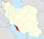
Kaki District
Persian: بخش كاكي | |
|---|---|
| Coordinates: 28°18′22″N 51°28′57″E / 28.30611°N 51.48250°E [1] | |
| Country | Iran |
| Province | Bushehr |
| County | Dashti |
| Capital | Kaki |
| Population (2016)
[2] | |
| • Total | 25,283 |
| Time zone | UTC+3:30 ( IRST) |
Kaki District ( Persian: بخش كاكي) is in Dashti County, Bushehr province, Iran. Its capital is the city of Kaki. [3]
History
After the 2011 National Census, the village of Baduleh was elevated to the status of a city. [4]
Demographics
Population
At the time of the 2006 census, the district's population was 22,798 in 4,764 households. [5] The following census in 2011 counted 23,157 people in 5,895 households. [6] The 2016 census measured the population of the district as 25,283 inhabitants living in 7,058 households. [2]
Administrative divisions
| Administrative Divisions | 2006 [5] | 2011 [6] | 2016 [2] |
|---|---|---|---|
| Cheghapur RD | 5,391 | 5,261 | 1,581 |
| Kabgan RD | 4,850 | 5,096 | 4,657 |
| Kaki RD | 2,664 | 2,644 | 2,898 |
| Baduleh (city) | 4,028 | ||
| Kaki (city) | 9,893 | 10,156 | 12,119 |
| Total | 22,798 | 23,157 | 25,283 |
| RD = Rural District | |||
See also
References
- ^ OpenStreetMap contributors (30 March 2023). "Kaki District (Dashti County)" (Map). OpenStreetMap (in Persian). Retrieved 30 March 2023.
- ^ a b c "Census of the Islamic Republic of Iran, 1395 (2016)". AMAR (in Persian). The Statistical Center of Iran. p. 18. Archived from the original (Excel) on 3 August 2017. Retrieved 19 December 2022.
- ^ Habibi, Hassan (7 July 1369). "Approval of the organization and chain of citizenship of elements and units of country divisions of Bushehr province centered on Bushehr city". Lamtakam (in Persian). Ministry of Interior, Political Defense Commission of the Government Board. Archived from the original on 24 April 2024. Retrieved 24 April 2024.
- ^ Rahimi, Mohammad Reza (16 September 2013). "Approval letter regarding country divisions in Bushehr province". Lamtakam (in Persian). Ministry of Interior, Council of Ministers. Archived from the original on 1 December 2023. Retrieved 1 December 2023.
- ^ a b "Census of the Islamic Republic of Iran, 1385 (2006)". AMAR (in Persian). The Statistical Center of Iran. p. 18. Archived from the original (Excel) on 20 September 2011. Retrieved 25 September 2022.
- ^ a b "Census of the Islamic Republic of Iran, 1390 (2011)". Syracuse University (in Persian). The Statistical Center of Iran. p. 18. Archived from the original (Excel) on 3 April 2023. Retrieved 19 December 2022.

