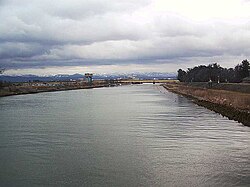
| Kakehashi River | |
|---|---|
 | |
| Native name | 梯川 ( Japanese) |
| Location | |
| Country | Japan |
| Physical characteristics | |
| Source | |
| • location | Suzugaoka |
| • elevation | 1,174 m (3,852 ft) |
| Mouth | |
• location | Sea of Japan |
| Length | 42 km (26 mi) |
| Basin size | 271 km2 (105 sq mi) |
The Kakehashi River (梯川, Kakehashi-gawa) has its source at Suzugaoka (鈴ヶ丘) in the city of Komatsu, Ishikawa Prefecture, Japan.
Geography
The river flows from Suzugaoka, which is part of the same mountain chain as Mount Haku. [1] It forms the southern border of Komatsu, separating it from Kaga.
References
- ^ Kakehashi-gawa Archived 2011-03-26 at the Wayback Machine. Ministry of Land, Infrastructure, Transportation and Tourism. Accessed October 27, 2010.
| Kakehashi River | |
|---|---|
 | |
| Native name | 梯川 ( Japanese) |
| Location | |
| Country | Japan |
| Physical characteristics | |
| Source | |
| • location | Suzugaoka |
| • elevation | 1,174 m (3,852 ft) |
| Mouth | |
• location | Sea of Japan |
| Length | 42 km (26 mi) |
| Basin size | 271 km2 (105 sq mi) |
The Kakehashi River (梯川, Kakehashi-gawa) has its source at Suzugaoka (鈴ヶ丘) in the city of Komatsu, Ishikawa Prefecture, Japan.
Geography
The river flows from Suzugaoka, which is part of the same mountain chain as Mount Haku. [1] It forms the southern border of Komatsu, separating it from Kaga.
References
- ^ Kakehashi-gawa Archived 2011-03-26 at the Wayback Machine. Ministry of Land, Infrastructure, Transportation and Tourism. Accessed October 27, 2010.