| Kōyasanchō Ishimichi-Tamagawakyō Prefectural Natural Park | |
|---|---|
| 高野山町石道玉川峡県立自然公園 | |
 | |
| Location | Wakayama Prefecture, Japan |
| Nearest city | Hashimoto, Katsuragi, Kōya, Kudoyama |
| Area | 6.45 square kilometres (2.49 sq mi) |
| Established | 6 January 1968 |
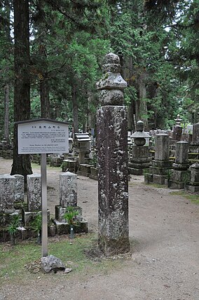
Kōyasanchō Ishimichi-Tamagawakyō Prefectural Natural Park (高野山町石道玉川峡県立自然公園, Kōyasan-chō Ishimichi Tamagawa-kyō kenritsu shizen kōen) is a Prefectural Natural Park in Wakayama Prefecture, Japan. Established in 1968, the park spans the borders of the municipalities of Hashimoto, Katsuragi, Kōya, and Kudoyama. The park comprises three non-contiguous areas, centred in turn upon Horaisan Jinja ( 宝来山神社) and the eponymous Kōyasan chōishi-michi and Tamagawa-kyō ( 玉川峡). [1] [2]
- National Parks of Japan
- Sacred Sites and Pilgrimage Routes in the Kii Mountain Range
- List of Historic Sites of Japan (Wakayama)
- List of Places of Scenic Beauty of Japan (Wakayama)
34°17′30″N 135°28′08″E / 34.291684°N 135.468811°E
- ^ 和歌山県の自然公園 [Natural Parks in Wakayama Prefecture] (in Japanese). Wakayama Prefecture. Retrieved 23 January 2021.
- ^ 高野山町石道玉川峡県立自然公園 [Kōyasanchō Ishimichi-Tamagawakyō Prefectural Natural Park] (in Japanese). Wakayama Prefecture. Archived from the original on 1 October 2020. Retrieved 23 January 2021.
| Kōyasanchō Ishimichi-Tamagawakyō Prefectural Natural Park | |
|---|---|
| 高野山町石道玉川峡県立自然公園 | |
 | |
| Location | Wakayama Prefecture, Japan |
| Nearest city | Hashimoto, Katsuragi, Kōya, Kudoyama |
| Area | 6.45 square kilometres (2.49 sq mi) |
| Established | 6 January 1968 |
Kōyasanchō Ishimichi-Tamagawakyō Prefectural Natural Park (高野山町石道玉川峡県立自然公園, Kōyasan-chō Ishimichi Tamagawa-kyō kenritsu shizen kōen) is a Prefectural Natural Park in Wakayama Prefecture, Japan. Established in 1968, the park spans the borders of the municipalities of Hashimoto, Katsuragi, Kōya, and Kudoyama. The park comprises three non-contiguous areas, centred in turn upon Horaisan Jinja ( 宝来山神社) and the eponymous Kōyasan chōishi-michi and Tamagawa-kyō ( 玉川峡). [1] [2]
- National Parks of Japan
- Sacred Sites and Pilgrimage Routes in the Kii Mountain Range
- List of Historic Sites of Japan (Wakayama)
- List of Places of Scenic Beauty of Japan (Wakayama)
34°17′30″N 135°28′08″E / 34.291684°N 135.468811°E
- ^ 和歌山県の自然公園 [Natural Parks in Wakayama Prefecture] (in Japanese). Wakayama Prefecture. Retrieved 23 January 2021.
- ^ 高野山町石道玉川峡県立自然公園 [Kōyasanchō Ishimichi-Tamagawakyō Prefectural Natural Park] (in Japanese). Wakayama Prefecture. Archived from the original on 1 October 2020. Retrieved 23 January 2021.