Photos • Location
You can help expand this article with text translated from
the corresponding article in German. (September 2011) Click [show] for important translation instructions.
|
| Küstriner Bach | |
|---|---|
 | |
| Location | |
| Country | Germany |
| State | Brandenburg |
| Physical characteristics | |
| Source | Großer Küstriner |
| Mouth | |
• location | Oberpfuhl |
• coordinates | 53°12′59″N 13°19′44″E / 53.2165°N 13.3290°E |
| Basin features | |
| Progression | Woblitz→ Havel→ Elbe→ North Sea |
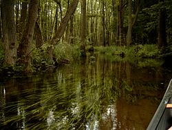
Küstriner Bach is a river of Brandenburg, Germany. It flows into the Oberpfuhl, which is drained by the Woblitz, near Lychen. It does not take its name from the town Küstrin ( Kostrzyn nad Odrą) but from the village Küstrinchen and the Großer Küstriner See, both near Lychen.
See also
You can help expand this article with text translated from
the corresponding article in German. (September 2011) Click [show] for important translation instructions.
|
| Küstriner Bach | |
|---|---|
 | |
| Location | |
| Country | Germany |
| State | Brandenburg |
| Physical characteristics | |
| Source | Großer Küstriner |
| Mouth | |
• location | Oberpfuhl |
• coordinates | 53°12′59″N 13°19′44″E / 53.2165°N 13.3290°E |
| Basin features | |
| Progression | Woblitz→ Havel→ Elbe→ North Sea |
Küstriner Bach is a river of Brandenburg, Germany. It flows into the Oberpfuhl, which is drained by the Woblitz, near Lychen. It does not take its name from the town Küstrin ( Kostrzyn nad Odrą) but from the village Küstrinchen and the Großer Küstriner See, both near Lychen.
See also