Photos • Location
City of Jardim Olinda | |
|---|---|
 Location of Jardim Olinda | |
| Coordinates: 22°32′56″S 52°03′39″W / 22.54889°S 52.06083°W | |
| Country |
|
| Region | South |
| State | Paraná |
| Founded | December 1, 1964 |
| Government | |
| • Mayor | Fernando Jorge Siroti |
| Area | |
| • Total | 128.515 km2 (49.620 sq mi) |
| Population (2020
[1]) | |
| • Total | 1,320 |
| • Density | 10.96/km2 (28.4/sq mi) |
| Time zone | UTC−3 ( BRT) |
| HDI (2000) | 0.724 – medium [2] |
| Website | Ponta Grossa, Paraná |
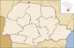
Jardim Olinda is the northernmost city in the Brazilian state of Paraná. The Saran Grande waterfall, located there, is the northernmost point in the state and in all Southern Brazil.
City of Jardim Olinda | |
|---|---|
 Location of Jardim Olinda | |
| Coordinates: 22°32′56″S 52°03′39″W / 22.54889°S 52.06083°W | |
| Country |
|
| Region | South |
| State | Paraná |
| Founded | December 1, 1964 |
| Government | |
| • Mayor | Fernando Jorge Siroti |
| Area | |
| • Total | 128.515 km2 (49.620 sq mi) |
| Population (2020
[1]) | |
| • Total | 1,320 |
| • Density | 10.96/km2 (28.4/sq mi) |
| Time zone | UTC−3 ( BRT) |
| HDI (2000) | 0.724 – medium [2] |
| Website | Ponta Grossa, Paraná |
Jardim Olinda is the northernmost city in the Brazilian state of Paraná. The Saran Grande waterfall, located there, is the northernmost point in the state and in all Southern Brazil.

