Irgenhausen | |
|---|---|
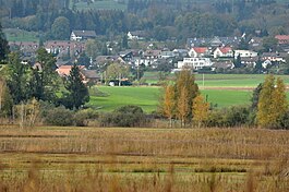
 Irgenhausen as seen from
Auslikon (April 2010) | |
| Coordinates: 47°21.58′N 8°47.6′E / 47.35967°N 8.7933°E | |
| Country | Switzerland |
| Canton | Zurich |
| District | Pfäffikon |
| Municipality | Pfäffikon |
| Elevation | 556 m (1,824 ft) |
| Population (December 2007) | |
| • Total | 0 |
| Time zone | UTC+01:00 ( Central European Time) |
| • Summer ( DST) | UTC+02:00 ( Central European Summer Time) |
| Postal code(s) | 8330 |
| ISO 3166 code | CH-ZH |
| Surrounded by | Auslikon, Kempten, Wetzikon |
| Website |
www |


Irgenhausen is a village ( Aussenwacht) of the municipality of Pfäffikon in the canton of Zurich in Switzerland.
Geography
Irgenhausen is located in the district of Pfäffikon in the Zürcher Oberland on the eastern shore of the Pfäffikersee (Lake Pfäffikon).
Demographics
Irgenhausen belongs politically to the municipality of Pfäffikon.
History

In Roman era, along Pfäffikersee there was a Roman road from the vicus Centum Prata ( Kempraten) on Obersee– Lake Zürich via Vitudurum ( Oberwinterthur) to Tasgetium ( Eschenz) to the Rhine. To secure this important transport route, the Irgenhausen Castrum was built. The native name of the fort is unknown, thus Irgenhausen was mentioned in 811 AD as Camputuna sive Irincheshusa. Maybe the castrum's name was Cambodunum, the name of the neighboring village of Kempten.
Points of interest
The Roman Irgenhausen Castrumis located in Irgenhausen on the shore of Pfäffikersee. [1]
Notable people
- Jakob Heusser (1862–1941), Swiss industrialist
References
External links
- Official website of the municipality of Pfäffikon (ZH) (in German)
- Irgenhausen in German, French and Italian in the online Historical Dictionary of Switzerland.
Irgenhausen | |
|---|---|
 Irgenhausen as seen from
Auslikon (April 2010) | |
| Coordinates: 47°21.58′N 8°47.6′E / 47.35967°N 8.7933°E | |
| Country | Switzerland |
| Canton | Zurich |
| District | Pfäffikon |
| Municipality | Pfäffikon |
| Elevation | 556 m (1,824 ft) |
| Population (December 2007) | |
| • Total | 0 |
| Time zone | UTC+01:00 ( Central European Time) |
| • Summer ( DST) | UTC+02:00 ( Central European Summer Time) |
| Postal code(s) | 8330 |
| ISO 3166 code | CH-ZH |
| Surrounded by | Auslikon, Kempten, Wetzikon |
| Website |
www |


Irgenhausen is a village ( Aussenwacht) of the municipality of Pfäffikon in the canton of Zurich in Switzerland.
Geography
Irgenhausen is located in the district of Pfäffikon in the Zürcher Oberland on the eastern shore of the Pfäffikersee (Lake Pfäffikon).
Demographics
Irgenhausen belongs politically to the municipality of Pfäffikon.
History

In Roman era, along Pfäffikersee there was a Roman road from the vicus Centum Prata ( Kempraten) on Obersee– Lake Zürich via Vitudurum ( Oberwinterthur) to Tasgetium ( Eschenz) to the Rhine. To secure this important transport route, the Irgenhausen Castrum was built. The native name of the fort is unknown, thus Irgenhausen was mentioned in 811 AD as Camputuna sive Irincheshusa. Maybe the castrum's name was Cambodunum, the name of the neighboring village of Kempten.
Points of interest
The Roman Irgenhausen Castrumis located in Irgenhausen on the shore of Pfäffikersee. [1]
Notable people
- Jakob Heusser (1862–1941), Swiss industrialist
References
External links
- Official website of the municipality of Pfäffikon (ZH) (in German)
- Irgenhausen in German, French and Italian in the online Historical Dictionary of Switzerland.

