Native name: Inis Meáin
[1] | |
|---|---|
 Inishmeane from Magheragallon Cemetery | |
 Inishmeane | |
| Geography | |
| Location | Atlantic Ocean |
| Coordinates | 55°06′15″N 8°20′46″W / 55.10417°N 8.34611°W |
| Area | 0.473 km2 (0.183 sq mi) [2] |
| Administration | |
| Province | Ulster |
| County | Donegal |
| Demographics | |
| Population | 7 (2011) |
Inishmeane ( Irish: Inis Meáin, meaning 'middle island [3]') is a small island and a townland off the coast of Gweedore, County Donegal, Ireland and was once home to a vibrant fishing community. The island has been unpopulated for decades but in recent years some people have started to return.
Inishmeane is around 1 kilometre off the coast of Gweedore. It lies between Gola Island (South-East) and Inishsirrer (North).
The island was inhabited up until the 1960s; today most of the buildings are derelict, but about eight have been renovated for use as holiday homes or permanent habitation. [3]
On Inishmeane there is no electricity nor freshwater public supply. [4]
A concrete pier was installed during the celtic tiger years to allow residents to moor their boats.[ citation needed]
The table below reports data on Inishmeane's population taken from Discover the Islands of Ireland (Alex Ritsema, Collins Press, 1999) and the Census of Ireland.
|
|
| |||||||||||||||||||||||||||||||||||||||||||||||||||||||||||||||||||||||||||||||||
| Source: Central Statistics Office. "CNA17: Population by Off Shore Island, Sex and Year". CSO.ie. Retrieved 12 October 2016. | |||||||||||||||||||||||||||||||||||||||||||||||||||||||||||||||||||||||||||||||||||
-
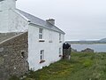 House on Inishmeane

- ^ "Inis Meáin". Placenames Database of Ireland. Dublin City University. Retrieved 22 February 2016.
- ^ General Alphabetical Index to the Townlands and Towns, Parishes, and Baronies of Ireland: Based on the Census of Ireland for the Year 1851. Genealogical Publishing Com. 1861. p. 539. ISBN 9780806310527. Retrieved 22 February 2016.
- ^ a b Wallace Clark (2003). Donegal Islands. Dundurn. p. 39. ISBN 9781900935319. Retrieved 22 February 2016.
- ^ David Walsh (2004). Oileáin: a guide to the Irish islands. Pesda press. p. 195. ISBN 9780953195695. Retrieved 22 February 2016.
![]() Media related to
Inishmeane at Wikimedia Commons
Media related to
Inishmeane at Wikimedia Commons
- Ecological study of two Donegal islands: Inishfree and Inishmeane
- Guide to the island
- Aerial view of the entire island

Native name: Inis Meáin
[1] | |
|---|---|
|
Inishmeane from Magheragallon Cemetery | |
Inishmeane | |
| Geography | |
| Location | Atlantic Ocean |
| Coordinates | 55°06′15″N 8°20′46″W / 55.10417°N 8.34611°W |
| Area | 0.473 km2 (0.183 sq mi) [2] |
| Administration | |
| Province | Ulster |
| County | Donegal |
| Demographics | |
| Population | 7 (2011) |
Inishmeane ( Irish: Inis Meáin, meaning 'middle island [3]') is a small island and a townland off the coast of Gweedore, County Donegal, Ireland and was once home to a vibrant fishing community. The island has been unpopulated for decades but in recent years some people have started to return.
Inishmeane is around 1 kilometre off the coast of Gweedore. It lies between Gola Island (South-East) and Inishsirrer (North).
The island was inhabited up until the 1960s; today most of the buildings are derelict, but about eight have been renovated for use as holiday homes or permanent habitation. [3]
On Inishmeane there is no electricity nor freshwater public supply. [4]
A concrete pier was installed during the celtic tiger years to allow residents to moor their boats.[ citation needed]
The table below reports data on Inishmeane's population taken from Discover the Islands of Ireland (Alex Ritsema, Collins Press, 1999) and the Census of Ireland.
|
|
| |||||||||||||||||||||||||||||||||||||||||||||||||||||||||||||||||||||||||||||||||
| Source: Central Statistics Office. "CNA17: Population by Off Shore Island, Sex and Year". CSO.ie. Retrieved 12 October 2016. | |||||||||||||||||||||||||||||||||||||||||||||||||||||||||||||||||||||||||||||||||||
-
House on Inishmeane
- ^ "Inis Meáin". Placenames Database of Ireland. Dublin City University. Retrieved 22 February 2016.
- ^ General Alphabetical Index to the Townlands and Towns, Parishes, and Baronies of Ireland: Based on the Census of Ireland for the Year 1851. Genealogical Publishing Com. 1861. p. 539. ISBN 9780806310527. Retrieved 22 February 2016.
- ^ a b Wallace Clark (2003). Donegal Islands. Dundurn. p. 39. ISBN 9781900935319. Retrieved 22 February 2016.
- ^ David Walsh (2004). Oileáin: a guide to the Irish islands. Pesda press. p. 195. ISBN 9780953195695. Retrieved 22 February 2016.
![]() Media related to
Inishmeane at Wikimedia Commons
Media related to
Inishmeane at Wikimedia Commons
- Ecological study of two Donegal islands: Inishfree and Inishmeane
- Guide to the island
- Aerial view of the entire island