Illesheim | |
|---|---|
 Coat of arms | |
Location of Illesheim within Neustadt a.d.Aisch-Bad Windsheim district 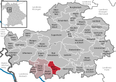 | |
 Illesheim  Illesheim | |
| Coordinates: 49°28′N 10°23′E / 49.467°N 10.383°E | |
| Country | Germany |
| State | Bavaria |
| Admin. region | Mittelfranken |
| District | Neustadt a.d.Aisch-Bad Windsheim |
| Municipal assoc. | Burgbernheim |
| Subdivisions | 4 Ortsteile |
| Government | |
| • Mayor (2020–26) | Roland Scheibenberger [1] |
| Area | |
| • Total | 21.43 km2 (8.27 sq mi) |
| Elevation | 321 m (1,053 ft) |
| Population (2022-12-31)
[2] | |
| • Total | 974 |
| • Density | 45/km2 (120/sq mi) |
| Time zone | UTC+01:00 ( CET) |
| • Summer ( DST) | UTC+02:00 ( CEST) |
| Postal codes | 91471 |
| Dialling codes | 09841 |
| Vehicle registration | NEA |
| Website | www.illesheim.de |
Illesheim, founded 1283 AD, is a municipality in the district of Neustadt (Aisch)-Bad Windsheim in Bavaria in Germany. The earliest leader affiliated with Illesheim's foundation was Götz von Berlichingen, known as "the Knight with the Iron Hand." Also known locally as "Illesa". It lies 6 kilometers west of Bad Windsheim and 11 kilometers east of the A7 motorway.
Illesheim has one train station, a stop on the Regionalbahn system. Its Rathaus (townhall) is open Wednesday afternoons and has some interesting historical items. This small town adjoins the northwestern edge of the U.S. Army's Storck Barracks and the Illesheim AAF, a U.S. Army helicopter airfield. The airfield previously belonged to the Luftwaffe until its capture in 1945.
Illesheim is primarily an agricultural town. The even smaller hamlet of Urfersheim sits to its southeast, adjoining the opposite side of the airfield.
On Illesheim's crest (in German, Wappen), the Wheel represents Illesheim at the center with the five wheel spokes pointing toward other smaller neighboring communities linked to the town Illesheim. The knife above represents Saint Bartholomew, who is the patron saint for the church in neighboring Urfersheim. The cross represents Saint Gumbertus, the patron saint for the church in the hamlet of Westheim (southeast of Urfersheim).
Mayor
The mayor of Illesheim is Roland Scheibenberger, elected in March 2020. [1]

References
- ^ a b Liste der ersten Bürgermeister/Oberbürgermeister in kreisangehörigen Gemeinden, Bayerisches Landesamt für Statistik, 15 July 2021.
- ^ Genesis Online-Datenbank des Bayerischen Landesamtes für Statistik Tabelle 12411-003r Fortschreibung des Bevölkerungsstandes: Gemeinden, Stichtag (Einwohnerzahlen auf Grundlage des Zensus 2011) ( Hilfe dazu).
Towns and municipalities in
Neustadt (Aisch)-Bad Windsheim | ||
|---|---|---|
|  | |
| International | |
|---|---|
| National | |
| Other | |
|
| This Neustadt (Aisch)-Bad Windsheim location article is a stub. You can help Wikipedia by expanding it. |
Illesheim | |
|---|---|
|
Coat of arms | |
Location of Illesheim within Neustadt a.d.Aisch-Bad Windsheim district | |
Illesheim Illesheim | |
| Coordinates: 49°28′N 10°23′E / 49.467°N 10.383°E | |
| Country | Germany |
| State | Bavaria |
| Admin. region | Mittelfranken |
| District | Neustadt a.d.Aisch-Bad Windsheim |
| Municipal assoc. | Burgbernheim |
| Subdivisions | 4 Ortsteile |
| Government | |
| • Mayor (2020–26) | Roland Scheibenberger [1] |
| Area | |
| • Total | 21.43 km2 (8.27 sq mi) |
| Elevation | 321 m (1,053 ft) |
| Population (2022-12-31)
[2] | |
| • Total | 974 |
| • Density | 45/km2 (120/sq mi) |
| Time zone | UTC+01:00 ( CET) |
| • Summer ( DST) | UTC+02:00 ( CEST) |
| Postal codes | 91471 |
| Dialling codes | 09841 |
| Vehicle registration | NEA |
| Website | www.illesheim.de |
Illesheim, founded 1283 AD, is a municipality in the district of Neustadt (Aisch)-Bad Windsheim in Bavaria in Germany. The earliest leader affiliated with Illesheim's foundation was Götz von Berlichingen, known as "the Knight with the Iron Hand." Also known locally as "Illesa". It lies 6 kilometers west of Bad Windsheim and 11 kilometers east of the A7 motorway.
Illesheim has one train station, a stop on the Regionalbahn system. Its Rathaus (townhall) is open Wednesday afternoons and has some interesting historical items. This small town adjoins the northwestern edge of the U.S. Army's Storck Barracks and the Illesheim AAF, a U.S. Army helicopter airfield. The airfield previously belonged to the Luftwaffe until its capture in 1945.
Illesheim is primarily an agricultural town. The even smaller hamlet of Urfersheim sits to its southeast, adjoining the opposite side of the airfield.
On Illesheim's crest (in German, Wappen), the Wheel represents Illesheim at the center with the five wheel spokes pointing toward other smaller neighboring communities linked to the town Illesheim. The knife above represents Saint Bartholomew, who is the patron saint for the church in neighboring Urfersheim. The cross represents Saint Gumbertus, the patron saint for the church in the hamlet of Westheim (southeast of Urfersheim).
Mayor
The mayor of Illesheim is Roland Scheibenberger, elected in March 2020. [1]
References
- ^ a b Liste der ersten Bürgermeister/Oberbürgermeister in kreisangehörigen Gemeinden, Bayerisches Landesamt für Statistik, 15 July 2021.
- ^ Genesis Online-Datenbank des Bayerischen Landesamtes für Statistik Tabelle 12411-003r Fortschreibung des Bevölkerungsstandes: Gemeinden, Stichtag (Einwohnerzahlen auf Grundlage des Zensus 2011) ( Hilfe dazu).
Towns and municipalities in
Neustadt (Aisch)-Bad Windsheim | ||
|---|---|---|
| | |
| International | |
|---|---|
| National | |
| Other | |
|
| This Neustadt (Aisch)-Bad Windsheim location article is a stub. You can help Wikipedia by expanding it. |