Photos • Location

이화동 벽화마을
Ihwa-dong | |
|---|---|
| Korean transcription(s) | |
| • Hangul | 이화동 |
| • Hanja | 梨 花 洞 |
| • Revised Romanization | Ihwa dong |
| • McCune–Reischauer | Ihwa tong |
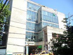
 Ihwa-dong Community Service Center (Jongno-gu) | |
| Country | South Korea |
| Area | |
| • Total | 0.78 km2 (0.30 sq mi) |
| Population (2001)
[1] | |
| • Total | 11,722 |
| • Density | 15,000/km2 (39,000/sq mi) |
Ihwa-dong is a dong, neighbourhood of Jongno-gu in Seoul, South Korea. [1] [2]

See also
References
- ^ a b "이화동 (Ihwa-dong 梨花洞)" (in Korean). Doosan Encyclopedia. Retrieved 2008-04-23.[ permanent dead link]
- ^ "Origin of Ihwa-dong's name" (in Korean). Jongno-gu official site. Archived from the original on 2004-08-20. Retrieved 2008-04-23.
- "종로구 (Jongno-gu 鍾路區)" (in Korean). Doosan Encyclopedia. Retrieved 2008-04-22.[ permanent dead link]
- "Chronicle of Beopjeong-dong and Haengjeong-dong" (in Korean). Guro-gu Official website. Archived from the original on 2014-10-06. Retrieved 2008-04-23.
- "Mapo Information". The chart of Beopjeong-dong assigned by Haengjeong-dong (행정동별 관할 법정동 일람표) (in Korean). Mapo-gu Official website. Archived from the original on 2007-11-05.
External links
- Jongno-gu Official site in English
- (in Korean) Jongno-gu Official site
- (in Korean) Status quo of Jongno-gu by administrative dong
- (in Korean) Ihwa-dong Resident office
- (in Korean) Origin of Ihwa-dong name[ permanent dead link]
Ihwa-dong | |
|---|---|
| Korean transcription(s) | |
| • Hangul | 이화동 |
| • Hanja | 梨 花 洞 |
| • Revised Romanization | Ihwa dong |
| • McCune–Reischauer | Ihwa tong |
 Ihwa-dong Community Service Center (Jongno-gu) | |
| Country | South Korea |
| Area | |
| • Total | 0.78 km2 (0.30 sq mi) |
| Population (2001)
[1] | |
| • Total | 11,722 |
| • Density | 15,000/km2 (39,000/sq mi) |
Ihwa-dong is a dong, neighbourhood of Jongno-gu in Seoul, South Korea. [1] [2]

See also
References
- ^ a b "이화동 (Ihwa-dong 梨花洞)" (in Korean). Doosan Encyclopedia. Retrieved 2008-04-23.[ permanent dead link]
- ^ "Origin of Ihwa-dong's name" (in Korean). Jongno-gu official site. Archived from the original on 2004-08-20. Retrieved 2008-04-23.
- "종로구 (Jongno-gu 鍾路區)" (in Korean). Doosan Encyclopedia. Retrieved 2008-04-22.[ permanent dead link]
- "Chronicle of Beopjeong-dong and Haengjeong-dong" (in Korean). Guro-gu Official website. Archived from the original on 2014-10-06. Retrieved 2008-04-23.
- "Mapo Information". The chart of Beopjeong-dong assigned by Haengjeong-dong (행정동별 관할 법정동 일람표) (in Korean). Mapo-gu Official website. Archived from the original on 2007-11-05.
External links
- Jongno-gu Official site in English
- (in Korean) Jongno-gu Official site
- (in Korean) Status quo of Jongno-gu by administrative dong
- (in Korean) Ihwa-dong Resident office
- (in Korean) Origin of Ihwa-dong name[ permanent dead link]
