Huisduinen | |
|---|---|
Village | |
 Huisduinen | |
 Flag | |
 Huisduinen Location in the Netherlands  Huisduinen Location in the province of North Holland in the Netherlands | |
| Coordinates: 52°57′8″N 4°43′34″E / 52.95222°N 4.72611°E | |
| Country | Netherlands |
| Province | North Holland |
| Municipality | Den Helder |
| Area | |
| • Total | 1.98 km2 (0.76 sq mi) |
| Elevation | 0.4 m (1.3 ft) |
| Population (2021)
[1] | |
| • Total | 600 |
| • Density | 300/km2 (780/sq mi) |
| Time zone | UTC+1 ( CET) |
| • Summer ( DST) | UTC+2 ( CEST) |
| Postal code | 1789
[1] |
| Dialing code | 0223 |
Huisduinen (Dutch pronunciation: [ˈɦœyzdœynə(n)]) is a village in the Dutch province of North Holland. It is a part of the municipality of Den Helder, and lies about 2 km west of Den Helder.
The village was first mentioned between 918 and 948 as Husidina, and means "house in the dunes". [3] A settlement more westwards had been known to exist in 866, but was lost in the sea in 1170. The second settlement disappeared in 1570. The current settlement was built around a 1574 sconce. In 1610, a dike was constructed to Callantsoog and Huisduinen was no longer an island. The town of Den Helder started to outgrow Huisduinen. [4] In 1672, the Battle of Texel (1672) which is named "Battle of Kijkduin" in Dutch took place near the village. [4]
The Dutch Reformed church is an aisleless church from 1851. Between 1895 and 1896, the church was extensively remodelled. The church contains a wooden model of a whaler from 1787. [4]
The fortress Kijkduin was built by Napoleon in Huisduinen between 1811 and 1813, and served to protect Den Helder. [4] In 1878, a lighthouse was built to the north of the fort. Nowadays, the fort houses a museum. [5]
Huisduinen was home to 327 people in 1840. [5] In 1942, the village was evacuated by the German authorities. [4]
-
 Fort Kijkduin
 -
 Hotel in Huisduinen
 -
 Art on the sea dike
 -
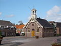 Dutch Reformed church


- ^ a b c "Kerncijfers wijken en buurten 2021". Central Bureau of Statistics. Retrieved 27 April 2022.
- ^ "Postcodetool for 1789AA". Actueel Hoogtebestand Nederland (in Dutch). Het Waterschapshuis. Retrieved 27 April 2022.
- ^ "Huisduinen - (geografische naam)". Etymologiebank (in Dutch). Retrieved 27 April 2022.
- ^ a b c d e Ronald Stenvert & Saskia van Ginkel-Meester (2006). "Huisduinen" (in Dutch). Zwolle: Waanders. Retrieved 27 April 2022.
- ^ a b "Huisduinen". Plaatsengids (in Dutch). Retrieved 27 April 2022.
| International | |
|---|---|
| National | |
Huisduinen | |
|---|---|
Village | |
|
Huisduinen | |
|
Flag | |
Huisduinen Location in the Netherlands Huisduinen Location in the province of North Holland in the Netherlands | |
| Coordinates: 52°57′8″N 4°43′34″E / 52.95222°N 4.72611°E | |
| Country | Netherlands |
| Province | North Holland |
| Municipality | Den Helder |
| Area | |
| • Total | 1.98 km2 (0.76 sq mi) |
| Elevation | 0.4 m (1.3 ft) |
| Population (2021)
[1] | |
| • Total | 600 |
| • Density | 300/km2 (780/sq mi) |
| Time zone | UTC+1 ( CET) |
| • Summer ( DST) | UTC+2 ( CEST) |
| Postal code | 1789
[1] |
| Dialing code | 0223 |
Huisduinen (Dutch pronunciation: [ˈɦœyzdœynə(n)]) is a village in the Dutch province of North Holland. It is a part of the municipality of Den Helder, and lies about 2 km west of Den Helder.
The village was first mentioned between 918 and 948 as Husidina, and means "house in the dunes". [3] A settlement more westwards had been known to exist in 866, but was lost in the sea in 1170. The second settlement disappeared in 1570. The current settlement was built around a 1574 sconce. In 1610, a dike was constructed to Callantsoog and Huisduinen was no longer an island. The town of Den Helder started to outgrow Huisduinen. [4] In 1672, the Battle of Texel (1672) which is named "Battle of Kijkduin" in Dutch took place near the village. [4]
The Dutch Reformed church is an aisleless church from 1851. Between 1895 and 1896, the church was extensively remodelled. The church contains a wooden model of a whaler from 1787. [4]
The fortress Kijkduin was built by Napoleon in Huisduinen between 1811 and 1813, and served to protect Den Helder. [4] In 1878, a lighthouse was built to the north of the fort. Nowadays, the fort houses a museum. [5]
Huisduinen was home to 327 people in 1840. [5] In 1942, the village was evacuated by the German authorities. [4]
-
Fort Kijkduin
-
Hotel in Huisduinen
-
Art on the sea dike
-
Dutch Reformed church
- ^ a b c "Kerncijfers wijken en buurten 2021". Central Bureau of Statistics. Retrieved 27 April 2022.
- ^ "Postcodetool for 1789AA". Actueel Hoogtebestand Nederland (in Dutch). Het Waterschapshuis. Retrieved 27 April 2022.
- ^ "Huisduinen - (geografische naam)". Etymologiebank (in Dutch). Retrieved 27 April 2022.
- ^ a b c d e Ronald Stenvert & Saskia van Ginkel-Meester (2006). "Huisduinen" (in Dutch). Zwolle: Waanders. Retrieved 27 April 2022.
- ^ a b "Huisduinen". Plaatsengids (in Dutch). Retrieved 27 April 2022.
| International | |
|---|---|
| National | |