Huby
German: Huben | |
|---|---|
 | |
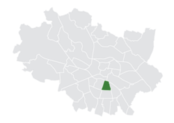
 Location of Huby within Wrocław | |
| Country | |
| Voivodeship | Lower Silesian |
| County/City | Wrocław |
| Incorporated into the city | 1868 |
| Established the modern-day district | 1991 |
| Population (2022) | |
| • Total | 18,727 |
| [1] | |
| Time zone | UTC+1 ( CET) |
| • Summer ( DST) | UTC+2 ( CEST) |
| Area code | +48 71 |
| Website | Osiedle Huby |
Huby (Polish pronunciation: [ˈxubɨ], German: Huben, [ˈhuːbən]) is a district in Wrocław located in the southern part of the city. It was established in the territory of the former Krzyki district.
Initially a village, the settlement was incorporated into Breslau (today's Wrocław) in 1868. [2] Huby's most important object is the city's main bus station, integrated with the Wroclavia shopping center. [3]
History
The earliest record of Huby dates back to 1346. The area has a history dating back to the Middle Ages, but its current role in the city was established in modern times. Architecturally, the estate is divided into two parts: the Old Huby, located between the railroad tracks and Kamienna Street, where pre-World War II kamienice dominate; and the area between Kamienna Street and Armii Krajowej Avenue, known as the New Huby, which was built in the 1970s. [3]
In 1991, after reforms in the administrative division of Wrocław, Huby became one of the city's 48 districts. [3] [4] In 2004, the neighborhood of Glinianki was incorporated into Huby. [5]
References
- ^ "Liczba mieszkańców zameldowanych we Wrocławiu w podziale na Osiedla – stan na 31 grudnia 2022 r."
- ^ "Ciekawa historia osiedla Huby". MiejscaWeWroclawiu.pl (in Polish). Retrieved 2024-01-02.
- ^ a b c "Huby". Bezpartyjny Wrocław (in Polish). Retrieved 2024-01-02.
- ^ "UCHWAŁA NR XX/110/91 RADY MIEJSKIEJ WROCŁAWIA z dnia 20 marca 1991 roku w sprawie podziału Wrocławia na osiedla".
- ^ "» "Wrocławski Niezbędnik Kulturalny": Gdzie stare miesza się z nowym". strefakultury.pl. Retrieved 2024-01-02.
Huby
German: Huben | |
|---|---|
 | |
 Location of Huby within Wrocław | |
| Country | |
| Voivodeship | Lower Silesian |
| County/City | Wrocław |
| Incorporated into the city | 1868 |
| Established the modern-day district | 1991 |
| Population (2022) | |
| • Total | 18,727 |
| [1] | |
| Time zone | UTC+1 ( CET) |
| • Summer ( DST) | UTC+2 ( CEST) |
| Area code | +48 71 |
| Website | Osiedle Huby |
Huby (Polish pronunciation: [ˈxubɨ], German: Huben, [ˈhuːbən]) is a district in Wrocław located in the southern part of the city. It was established in the territory of the former Krzyki district.
Initially a village, the settlement was incorporated into Breslau (today's Wrocław) in 1868. [2] Huby's most important object is the city's main bus station, integrated with the Wroclavia shopping center. [3]
History
The earliest record of Huby dates back to 1346. The area has a history dating back to the Middle Ages, but its current role in the city was established in modern times. Architecturally, the estate is divided into two parts: the Old Huby, located between the railroad tracks and Kamienna Street, where pre-World War II kamienice dominate; and the area between Kamienna Street and Armii Krajowej Avenue, known as the New Huby, which was built in the 1970s. [3]
In 1991, after reforms in the administrative division of Wrocław, Huby became one of the city's 48 districts. [3] [4] In 2004, the neighborhood of Glinianki was incorporated into Huby. [5]
References
- ^ "Liczba mieszkańców zameldowanych we Wrocławiu w podziale na Osiedla – stan na 31 grudnia 2022 r."
- ^ "Ciekawa historia osiedla Huby". MiejscaWeWroclawiu.pl (in Polish). Retrieved 2024-01-02.
- ^ a b c "Huby". Bezpartyjny Wrocław (in Polish). Retrieved 2024-01-02.
- ^ "UCHWAŁA NR XX/110/91 RADY MIEJSKIEJ WROCŁAWIA z dnia 20 marca 1991 roku w sprawie podziału Wrocławia na osiedla".
- ^ "» "Wrocławski Niezbędnik Kulturalny": Gdzie stare miesza się z nowym". strefakultury.pl. Retrieved 2024-01-02.