Photos • Location
Hongxing
红星区 | |
|---|---|
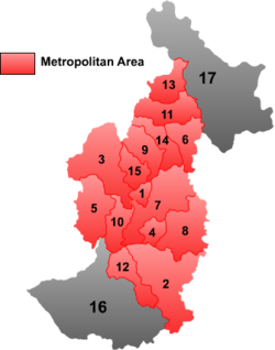
 Location of Hongxing ("14") within Yichun City | |
 Location of Yichun City in Heilongjiang | |
| Coordinates: 48°14′22″N 129°23′28″E / 48.23944°N 129.39111°E | |
| Country | People's Republic of China |
| Province | Heilongjiang |
| Prefecture-level city | Yichun |
| Area | |
| • Total | 3,042 km2 (1,175 sq mi) |
| Population (2003) | |
| • Total | 30,000 |
| • Density | 9.9/km2 (26/sq mi) |
| Time zone | UTC+8 ( China Standard) |
Hongxing District ( simplified Chinese: 红星区; traditional Chinese: 紅星區; pinyin: Hóngxīng Qū; lit. 'red star') is a district of the city of Yichun, Heilongjiang province, People's Republic of China.
Hongxing
红星区 | |
|---|---|
 Location of Hongxing ("14") within Yichun City | |
 Location of Yichun City in Heilongjiang | |
| Coordinates: 48°14′22″N 129°23′28″E / 48.23944°N 129.39111°E | |
| Country | People's Republic of China |
| Province | Heilongjiang |
| Prefecture-level city | Yichun |
| Area | |
| • Total | 3,042 km2 (1,175 sq mi) |
| Population (2003) | |
| • Total | 30,000 |
| • Density | 9.9/km2 (26/sq mi) |
| Time zone | UTC+8 ( China Standard) |
Hongxing District ( simplified Chinese: 红星区; traditional Chinese: 紅星區; pinyin: Hóngxīng Qū; lit. 'red star') is a district of the city of Yichun, Heilongjiang province, People's Republic of China.