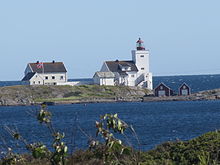
 View of the lighthouse | |
|
| |
| Location | Agder, Norway |
|---|---|
| Coordinates | 58°15′14″N 8°31′46″E / 58.253903°N 08.529359°E |
| Tower | |
| Constructed | 1879 |
| Construction | Concrete |
| Automated | 1992 |
| Height | 20.1 metres (66 ft) |
| Shape | Square tower |
| Markings | White with red top |
| Heritage | heritage site in Norway
|
| Light | |
| Focal height | 22.3 metres (73 ft) |
| Lens | 3rd order Fresnel lens |
| Intensity | 58,500
cd (fixed) 423,900 cd (flash) |
| Range | 14.5 nmi (26.9 km; 16.7 mi) |
| Characteristic | FFl(4) W 60s |
| Norway no. | 066500 |
Homborsund Lighthouse ( Norwegian: Homborsund fyr) is a coastal lighthouse located on the island Store Grønningen in the municipality of Grimstad in Agder county, Norway. It sits about 2 kilometres (1.2 mi) southeast of the village of Homborsund in the Eide area. It was established in 1879, and is listed as a protected cultural site. Homborsund Lighthouse was constructed the same year as Lyngør Lighthouse, and the two stations have similar designs. The station includes a livinghouse for two families, outhouse, boathouse and pier, in addition to the light. The light was automated in 1992, and the station was de-populated. Today it is open to the public for overnight stays and guidance. The surrounding area is a protected bird sanctuary. [1] [2]
The 20.1-metre (66 ft) tall, white, square-shaped tower has a red top. The light on top sits at an elevation of 22.3 metres (73 ft) above sea level. The light can be seen for up to 14.5 nautical miles (26.9 km; 16.7 mi). The 3rd order Fresnel lens on top emits a continuous white light with four brighter flashes every 60 seconds. The light has an intensity of 58,500 candela, but during the brighter flashes, the light reaches an intensity of 423,900 candela. [3] [4]
See also
References
- ^ Godal, Anne Marit (ed.). "Homborsund fyr". Store norske leksikon (in Norwegian). Oslo: Norsk nettleksikon. Retrieved 7 April 2012.
- ^ "Homborsund fyrstasjon" (in Norwegian). Norsk Fyrhistorisk Forening. Retrieved 7 April 2012.
- ^ Rowlett, Russ (19 July 2011). "Lighthouses of Norway: Aust-Agder (Arendal Area)". The Lighthouse Directory. University of North Carolina at Chapel Hill. Retrieved 13 November 2017.
- ^ Kystverket (2014). Norske Fyrliste 2014 (PDF) (in Norwegian). ISBN 9788245015959. Archived from the original (PDF) on 12 June 2018. Retrieved 14 November 2017.
External links
- Norsk Fyrhistorisk Forening (in Norwegian)