Photos • Location

Holy Cross, Kentucky | |
|---|---|
 Holy Cross  Holy Cross | |
| Coordinates: 37°40′26″N 85°26′49″W / 37.67389°N 85.44694°W | |
| Country | United States |
| State | Kentucky |
| County | Marion |
| Elevation | 682 ft (208 m) |
| Time zone | UTC-5 ( Eastern (EST)) |
| • Summer ( DST) | UTC-4 (EST) |
| GNIS feature ID | 494449 [1] |
Holy Cross is an unincorporated community in Marion County, Kentucky, United States. Its post office is closed. [2] The town developed at the site of the first Roman Catholic church in Kentucky. [3]
See also
References
- ^ U.S. Geological Survey Geographic Names Information System: Holy Cross, Kentucky
- ^ U.S. Geological Survey Geographic Names Information System: Holy Cross KY post office
- ^ Kleber, John E. (1992). The Kentucky encyclopedia. University Press of Kentucky. ISBN 0-8131-1772-0. OCLC 636324612.
Municipalities and communities of
Marion County, Kentucky, United States | ||
|---|---|---|
| Cities | 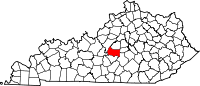 | |
|
Unincorporated communities | ||
|
| This Marion County, Kentucky state location article is a stub. You can help Wikipedia by expanding it. |
Holy Cross, Kentucky | |
|---|---|
Holy Cross Holy Cross | |
| Coordinates: 37°40′26″N 85°26′49″W / 37.67389°N 85.44694°W | |
| Country | United States |
| State | Kentucky |
| County | Marion |
| Elevation | 682 ft (208 m) |
| Time zone | UTC-5 ( Eastern (EST)) |
| • Summer ( DST) | UTC-4 (EST) |
| GNIS feature ID | 494449 [1] |
Holy Cross is an unincorporated community in Marion County, Kentucky, United States. Its post office is closed. [2] The town developed at the site of the first Roman Catholic church in Kentucky. [3]
See also
References
- ^ U.S. Geological Survey Geographic Names Information System: Holy Cross, Kentucky
- ^ U.S. Geological Survey Geographic Names Information System: Holy Cross KY post office
- ^ Kleber, John E. (1992). The Kentucky encyclopedia. University Press of Kentucky. ISBN 0-8131-1772-0. OCLC 636324612.
Municipalities and communities of
Marion County, Kentucky, United States | ||
|---|---|---|
| Cities | | |
|
Unincorporated communities | ||
|
| This Marion County, Kentucky state location article is a stub. You can help Wikipedia by expanding it. |