Holden | |
|---|---|
| Village of Holden | |
 Main street | |
| Motto: Share the Charm of Country Living | |
 Holden | |
| Coordinates: 53°13′59″N 112°14′6″W / 53.23306°N 112.23500°W | |
| Country | Canada |
| Province | Alberta |
| Region | Central Alberta |
| Census Division | No. 10 |
| Municipal district | Beaver County |
| Incorporated [1] | |
| • Village | April 14, 1909 |
| Government | |
| • Mayor | Tyler Beckett |
| • Governing body | Holden Village Council |
| • CAO | Rosemary Offrey |
| Area (2021)
[3] | |
| • Land | 1.55 km2 (0.60 sq mi) |
| Elevation | 686 m (2,251 ft) |
| Population (2021)
[3] | |
| • Total | 338 |
| • Density | 217.7/km2 (564/sq mi) |
| Time zone | UTC-7 ( MST) |
| • Summer ( DST) | UTC-6 (MDT) |
| Postal Code | |
| Area code | 780 |
| Highways |
14 855 |
| Waterways | Creeks in the area form the head of Vermilion River |
| Website | Official website |
Holden is a village in central Alberta, Canada. It is located south of Vegreville. The village is named after former Alberta MLA James Holden.
In the 2021 Census of Population conducted by Statistics Canada, the Village of Holden had a population of 338 living in 171 of its 205 total private dwellings, a change of -3.4% from its 2016 population of 350. With a land area of 1.55 km2 (0.60 sq mi), it had a population density of 218.1/km2 (564.8/sq mi) in 2021. [3]
In the 2016 Census of Population conducted by Statistics Canada, the Village of Holden recorded a population of 350 living in 146 of its 167 total private dwellings, a change of -8.1% from its 2011 population of 381. With a land area of 1.74 km2 (0.67 sq mi), it had a population density of 201.1/km2 (521.0/sq mi) in 2016. [4]
-
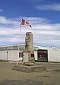 Cenotaph in middle of main street

- Dale Armstrong, drag racer
- Ted Newall, businessman
- List of communities in Alberta
- List of francophone communities in Alberta
- List of villages in Alberta
- ^ "Location and History Profile: Village of Holden" (PDF). Alberta Municipal Affairs. February 16, 2024. p. 339. Retrieved February 20, 2024.
- ^ "Municipal Officials Search". Alberta Municipal Affairs. May 9, 2019. Retrieved October 1, 2021.
- ^ a b c "Population and dwelling counts: Canada, provinces and territories, and census subdivisions (municipalities)". Statistics Canada. February 9, 2022. Retrieved February 9, 2022.
- ^ "Population and dwelling counts, for Canada, provinces and territories, and census subdivisions (municipalities), 2016 and 2011 censuses – 100% data (Alberta)". Statistics Canada. February 8, 2017. Retrieved February 8, 2017.
Places adjacent to Holden, Alberta | |
|---|---|
Holden | |
|---|---|
| Village of Holden | |
|
Main street | |
| Motto: Share the Charm of Country Living | |
Holden | |
| Coordinates: 53°13′59″N 112°14′6″W / 53.23306°N 112.23500°W | |
| Country | Canada |
| Province | Alberta |
| Region | Central Alberta |
| Census Division | No. 10 |
| Municipal district | Beaver County |
| Incorporated [1] | |
| • Village | April 14, 1909 |
| Government | |
| • Mayor | Tyler Beckett |
| • Governing body | Holden Village Council |
| • CAO | Rosemary Offrey |
| Area (2021)
[3] | |
| • Land | 1.55 km2 (0.60 sq mi) |
| Elevation | 686 m (2,251 ft) |
| Population (2021)
[3] | |
| • Total | 338 |
| • Density | 217.7/km2 (564/sq mi) |
| Time zone | UTC-7 ( MST) |
| • Summer ( DST) | UTC-6 (MDT) |
| Postal Code | |
| Area code | 780 |
| Highways |
14 855 |
| Waterways | Creeks in the area form the head of Vermilion River |
| Website | Official website |
Holden is a village in central Alberta, Canada. It is located south of Vegreville. The village is named after former Alberta MLA James Holden.
In the 2021 Census of Population conducted by Statistics Canada, the Village of Holden had a population of 338 living in 171 of its 205 total private dwellings, a change of -3.4% from its 2016 population of 350. With a land area of 1.55 km2 (0.60 sq mi), it had a population density of 218.1/km2 (564.8/sq mi) in 2021. [3]
In the 2016 Census of Population conducted by Statistics Canada, the Village of Holden recorded a population of 350 living in 146 of its 167 total private dwellings, a change of -8.1% from its 2011 population of 381. With a land area of 1.74 km2 (0.67 sq mi), it had a population density of 201.1/km2 (521.0/sq mi) in 2016. [4]
-
Cenotaph in middle of main street
- Dale Armstrong, drag racer
- Ted Newall, businessman
- List of communities in Alberta
- List of francophone communities in Alberta
- List of villages in Alberta
- ^ "Location and History Profile: Village of Holden" (PDF). Alberta Municipal Affairs. February 16, 2024. p. 339. Retrieved February 20, 2024.
- ^ "Municipal Officials Search". Alberta Municipal Affairs. May 9, 2019. Retrieved October 1, 2021.
- ^ a b c "Population and dwelling counts: Canada, provinces and territories, and census subdivisions (municipalities)". Statistics Canada. February 9, 2022. Retrieved February 9, 2022.
- ^ "Population and dwelling counts, for Canada, provinces and territories, and census subdivisions (municipalities), 2016 and 2011 censuses – 100% data (Alberta)". Statistics Canada. February 8, 2017. Retrieved February 8, 2017.
Places adjacent to Holden, Alberta | |
|---|---|