Photos • Location

Ria Visser, 1984

Hoeksche Waard | |
|---|---|
 View of Tiengemeten and Hoeksche Waard | |
 Flag  Coat of arms | |
.svg) Location in South Holland | |
| Coordinates: 51°46′N 4°28′E / 51.77°N 4.47°E | |
| Country | Netherlands |
| Province | South Holland |
| Government | |
| • Body | Municipal council |
| • Mayor | Bram van Hemmen ( CDA) |
| Area | |
| • Total | 323.74 km2 (125.00 sq mi) |
| Population (July 2019)
[2] | |
| • Total | 87,199 |
| • Density | 270/km2 (700/sq mi) |
| Time zone | UTC+1 ( CET) |
| • Summer ( DST) | UTC+2 ( CEST) |
| Website |
www |
Hoeksche Waard (Dutch pronunciation: [ˈɦuksə ˌʋaːrt]) is a municipality in the western Netherlands, in the province of South Holland, consisting of the eponymous Hoeksche Waard and Tiengemeten islands.
The municipality was formed on 1 January 2019 by the merger of the municipalities Binnenmaas, Cromstrijen, Korendijk, Oud-Beijerland, and Strijen. [3]
Gallery
-
 's-Gravendeel, church: the Kerk op de Heul
 -
 's-Gravendeel, windmill: korenmolen het Vliegend Hert
 -
 Westmaas, reformed church
 -
 Klaaswaal, reformed church
 -
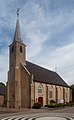
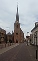 Strijen, church: the Grote- or Sint Lambertuskerk
 -
 Maasdam, the Church
 -
 Puttershoek, windmill: korenmolen de Lelie
 -
 Nieuw-Beijerland, windmill: windmolen de Swaan


Notable people
- Lamoral, Count of Egmont (1522–1568) a general and statesman, Lord of Oud-Beijerland. [4]
- Philip, Count of Egmont (1558 – 1590) the fifth Count of Egmont and Lord of Oud-Beijerland
- Thomas van der Wilt (1659 in Piershil – 1733) a Dutch painter
- Philip van Dijk (1683 in Oud-Beijerland – 1753) a Dutch painter
- Stoffel Muller (1776 in Puttershoek – 1833) leader of a small Dutch Protestant sect Zwijndrechtse nieuwlichters
- Suze Groeneweg (born 1875 in Strijensas - 1940) a Dutch politician, the first woman to be elected to the Dutch parliament
- Renée Jones-Bos (born 1952 in Oud-Beijerland) a Dutch senior civil servant and diplomat
- Ineke Dezentjé Hamming-Bluemink (born 1954) a former Dutch politician and municipal councillor in Cromstrijen
- Anton Corbijn (born 1955 in Strijen) a Dutch photographer, music video director and film director [5]
- Eibert Tigchelaar (born 1959 in Sint Anthoniepolder) academic and expert on the Dead Sea Scrolls
- Carlo Resoort (born 1973 in Numansdorp) a Dutch DJ, remixer and producer; plays with the 4 Strings
- Benno de Goeij (born 1975 in Oud-Beijerland) a Dutch record producer, works with Armin van Buuren
- Vivienne van den Assem (born 1983) a Dutch actress and presenter, brought up in Oud-Beijerland [6]
Sport

- Nijs Korevaar (1927 in Mijnsheerenland – 2016) a Dutch water polo player, team bronze medallist at the 1948 Summer Olympics
- Kees Verkerk (born 1942 in Maasdam) a former speed skater, three time winter Olympic silver medallist and gold medallist at the 1968 Winter Olympics
- Adri van Tiggelen (born 1957 in Oud-Beijerland) a retired Dutch footballer with 505 club caps
- Ria Visser (born 1961 in Oud-Beijerland) a former ice speed skater and silver medallist at the 1980 Winter Olympics
- Kristie Boogert (born 1973 in Oud-Beijerland) a former professional female tennis player and team silver medallist at the 2000 Summer Olympics
References
- ^ "Kerncijfers wijken en buurten 2020" [Key figures for neighbourhoods 2020]. StatLine (in Dutch). CBS. 24 July 2020. Retrieved 19 September 2020.
- ^ "Bevolkingsontwikkeling; regio per maand" [Population growth; regions per month]. CBS Statline (in Dutch). CBS. 1 January 2021. Retrieved 2 January 2022.
- ^ Wet samenvoeging gemeenten Binnenmaas, Cromstrijen, Korendijk, Oud-Beijerland en Strijen, 11 July 2018, accessed at overheid.nl
- ^ . Encyclopedia Americana. Vol. IX. 1920.
- ^ IMDb Database retrieved 28 February 2020
- ^ IMDb Database retrieved 28 February 2020
External links
-
 Media related to
Hoeksche Waard at Wikimedia Commons
Media related to
Hoeksche Waard at Wikimedia Commons - Official website
Places adjacent to Hoeksche Waard | |
|---|---|

Hoeksche Waard | |
|---|---|
|
View of Tiengemeten and Hoeksche Waard | |
|
Flag Coat of arms | |
|
Location in South Holland | |
| Coordinates: 51°46′N 4°28′E / 51.77°N 4.47°E | |
| Country | Netherlands |
| Province | South Holland |
| Government | |
| • Body | Municipal council |
| • Mayor | Bram van Hemmen ( CDA) |
| Area | |
| • Total | 323.74 km2 (125.00 sq mi) |
| Population (July 2019)
[2] | |
| • Total | 87,199 |
| • Density | 270/km2 (700/sq mi) |
| Time zone | UTC+1 ( CET) |
| • Summer ( DST) | UTC+2 ( CEST) |
| Website |
www |
Hoeksche Waard (Dutch pronunciation: [ˈɦuksə ˌʋaːrt]) is a municipality in the western Netherlands, in the province of South Holland, consisting of the eponymous Hoeksche Waard and Tiengemeten islands.
The municipality was formed on 1 January 2019 by the merger of the municipalities Binnenmaas, Cromstrijen, Korendijk, Oud-Beijerland, and Strijen. [3]
Gallery
-
's-Gravendeel, church: the Kerk op de Heul
-
's-Gravendeel, windmill: korenmolen het Vliegend Hert
-
Westmaas, reformed church
-
Klaaswaal, reformed church
-
Strijen, church: the Grote- or Sint Lambertuskerk
-
Maasdam, the Church
-
Puttershoek, windmill: korenmolen de Lelie
-
Nieuw-Beijerland, windmill: windmolen de Swaan
Notable people
- Lamoral, Count of Egmont (1522–1568) a general and statesman, Lord of Oud-Beijerland. [4]
- Philip, Count of Egmont (1558 – 1590) the fifth Count of Egmont and Lord of Oud-Beijerland
- Thomas van der Wilt (1659 in Piershil – 1733) a Dutch painter
- Philip van Dijk (1683 in Oud-Beijerland – 1753) a Dutch painter
- Stoffel Muller (1776 in Puttershoek – 1833) leader of a small Dutch Protestant sect Zwijndrechtse nieuwlichters
- Suze Groeneweg (born 1875 in Strijensas - 1940) a Dutch politician, the first woman to be elected to the Dutch parliament
- Renée Jones-Bos (born 1952 in Oud-Beijerland) a Dutch senior civil servant and diplomat
- Ineke Dezentjé Hamming-Bluemink (born 1954) a former Dutch politician and municipal councillor in Cromstrijen
- Anton Corbijn (born 1955 in Strijen) a Dutch photographer, music video director and film director [5]
- Eibert Tigchelaar (born 1959 in Sint Anthoniepolder) academic and expert on the Dead Sea Scrolls
- Carlo Resoort (born 1973 in Numansdorp) a Dutch DJ, remixer and producer; plays with the 4 Strings
- Benno de Goeij (born 1975 in Oud-Beijerland) a Dutch record producer, works with Armin van Buuren
- Vivienne van den Assem (born 1983) a Dutch actress and presenter, brought up in Oud-Beijerland [6]
Sport
- Nijs Korevaar (1927 in Mijnsheerenland – 2016) a Dutch water polo player, team bronze medallist at the 1948 Summer Olympics
- Kees Verkerk (born 1942 in Maasdam) a former speed skater, three time winter Olympic silver medallist and gold medallist at the 1968 Winter Olympics
- Adri van Tiggelen (born 1957 in Oud-Beijerland) a retired Dutch footballer with 505 club caps
- Ria Visser (born 1961 in Oud-Beijerland) a former ice speed skater and silver medallist at the 1980 Winter Olympics
- Kristie Boogert (born 1973 in Oud-Beijerland) a former professional female tennis player and team silver medallist at the 2000 Summer Olympics
References
- ^ "Kerncijfers wijken en buurten 2020" [Key figures for neighbourhoods 2020]. StatLine (in Dutch). CBS. 24 July 2020. Retrieved 19 September 2020.
- ^ "Bevolkingsontwikkeling; regio per maand" [Population growth; regions per month]. CBS Statline (in Dutch). CBS. 1 January 2021. Retrieved 2 January 2022.
- ^ Wet samenvoeging gemeenten Binnenmaas, Cromstrijen, Korendijk, Oud-Beijerland en Strijen, 11 July 2018, accessed at overheid.nl
- ^ . Encyclopedia Americana. Vol. IX. 1920.
- ^ IMDb Database retrieved 28 February 2020
- ^ IMDb Database retrieved 28 February 2020
External links
-
Media related to
Hoeksche Waard at Wikimedia Commons
- Official website
Places adjacent to Hoeksche Waard | |
|---|---|