Hobovše pri Stari Oselici | |
|---|---|
 | |
| Coordinates: 46°4′59.83″N 14°3′54.98″E / 46.0832861°N 14.0652722°E | |
| Country |
|
| Traditional region | Upper Carniola |
| Statistical region | Upper Carniola |
| Municipality | Gorenja Vas–Poljane |
| Area | |
| • Total | 1.39 km2 (0.54 sq mi) |
| Elevation | 560.7 m (1,839.6 ft) |
| Population (2020) | |
| • Total | 65 |
| • Density | 47/km2 (120/sq mi) |
| [1] | |
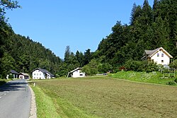
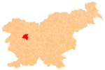
Hobovše pri Stari Oselici (pronounced [xɔˈboːu̯ʃɛ pɾi ˈstaːɾi ˈoːsɛlitsi]; German: Hobousche bei Altoßlitz [2]) is a dispersed settlement south of Stara Oselica in the Municipality of Gorenja Vas–Poljane in the Upper Carniola region of Slovenia. [3]
Name
The name Hobovše pri Stari Oselici means 'Hobovše near Stara Oselica'. The village was attested in historical sources as Chotwůsse in 1291, Chotwůsche in 1318, and Chadbuesch in 1500. [4] [5] The name is believed to derive from the plural demonym *Hotebǫďe-vьsʼane 'residents of Hotebǫdъ's village', referring to an early individual associated with the settlement. [5]
References
- ^ Statistical Office of the Republic of Slovenia
- ^ Leksikon občin kraljestev in dežel zastopanih v državnem zboru, vol. 6: Kranjsko. Vienna: C. Kr. Dvorna in Državna Tiskarna. 1906. p. 58.
- ^ Gorenja Vas–Poljane municipal site
- ^ "Slovenska historična topografija". Retrieved February 10, 2020.
- ^ a b Snoj, Marko (2009). Etimološki slovar slovenskih zemljepisnih imen. Ljubljana: Modrijan. pp. 159–160.
External links
-
 Media related to
Hobovše pri Stari Oselici at Wikimedia Commons
 - Hobovše pri Stari Oselici on Geopedia
Hobovše pri Stari Oselici | |
|---|---|
 | |
| Coordinates: 46°4′59.83″N 14°3′54.98″E / 46.0832861°N 14.0652722°E | |
| Country |
|
| Traditional region | Upper Carniola |
| Statistical region | Upper Carniola |
| Municipality | Gorenja Vas–Poljane |
| Area | |
| • Total | 1.39 km2 (0.54 sq mi) |
| Elevation | 560.7 m (1,839.6 ft) |
| Population (2020) | |
| • Total | 65 |
| • Density | 47/km2 (120/sq mi) |
| [1] | |
Hobovše pri Stari Oselici (pronounced [xɔˈboːu̯ʃɛ pɾi ˈstaːɾi ˈoːsɛlitsi]; German: Hobousche bei Altoßlitz [2]) is a dispersed settlement south of Stara Oselica in the Municipality of Gorenja Vas–Poljane in the Upper Carniola region of Slovenia. [3]
Name
The name Hobovše pri Stari Oselici means 'Hobovše near Stara Oselica'. The village was attested in historical sources as Chotwůsse in 1291, Chotwůsche in 1318, and Chadbuesch in 1500. [4] [5] The name is believed to derive from the plural demonym *Hotebǫďe-vьsʼane 'residents of Hotebǫdъ's village', referring to an early individual associated with the settlement. [5]
References
- ^ Statistical Office of the Republic of Slovenia
- ^ Leksikon občin kraljestev in dežel zastopanih v državnem zboru, vol. 6: Kranjsko. Vienna: C. Kr. Dvorna in Državna Tiskarna. 1906. p. 58.
- ^ Gorenja Vas–Poljane municipal site
- ^ "Slovenska historična topografija". Retrieved February 10, 2020.
- ^ a b Snoj, Marko (2009). Etimološki slovar slovenskih zemljepisnih imen. Ljubljana: Modrijan. pp. 159–160.
External links
-
 Media related to
Hobovše pri Stari Oselici at Wikimedia Commons
 - Hobovše pri Stari Oselici on Geopedia

