Photos • Location
Hlabta
حلبتا | |
|---|---|
Village | |
| Coordinates: 34°15′19″N 36°17′15″E / 34.25528°N 36.28750°E | |
| Country | |
| Governorate | Baalbek-Hermel Governorate |
| District | Baalbek District |
| Elevation | 3,900 ft (1,200 m) |
| Time zone | UTC+2 ( EET) |
| • Summer ( DST) | +3 |
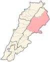
Hlabta ( Arabic: حلبتا) is a village located in the Baalbek District of the Baalbek-Hermel Governorate in Lebanon. [1]
References
- ^ "Hlabta (Baalbek)". Localiban. Localiban. 2007-12-07. Retrieved 2017-12-01.

