Photos • Location
Hinthada District
ဟင်္သာတခရိုင် Henzada District | |
|---|---|
District of
Ayeyarwady Division | |
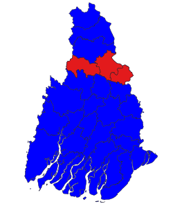
 location in Ayeyarwady region | |
| Coordinates: 17°38′0″N 95°30′0″E / 17.63333°N 95.50000°E | |
| Country | Myanmar |
| Division | Ayeyarwady |
| District | Hinthada |
| Area | |
| • Total | 6,985.9 km2 (2,697.3 sq mi) |
| Population (2014) | |
| • Total | 1,138,710 |
| • Density | 160/km2 (420/sq mi) |
| Time zone | UTC6:30 ( MST) |
Hinthada District ( Burmese: ဟင်္သာတခရိုင်; formerly Henzada District) is a district of Ayeyarwady Division, Myanmar.
The district contains the following townships:
- Hinthada Township
- Zalun Township
- Lemyethna Township (Laymyethna)
Hinthada District
ဟင်္သာတခရိုင် Henzada District | |
|---|---|
District of
Ayeyarwady Division | |
 location in Ayeyarwady region | |
| Coordinates: 17°38′0″N 95°30′0″E / 17.63333°N 95.50000°E | |
| Country | Myanmar |
| Division | Ayeyarwady |
| District | Hinthada |
| Area | |
| • Total | 6,985.9 km2 (2,697.3 sq mi) |
| Population (2014) | |
| • Total | 1,138,710 |
| • Density | 160/km2 (420/sq mi) |
| Time zone | UTC6:30 ( MST) |
Hinthada District ( Burmese: ဟင်္သာတခရိုင်; formerly Henzada District) is a district of Ayeyarwady Division, Myanmar.
The district contains the following townships:
- Hinthada Township
- Zalun Township
- Lemyethna Township (Laymyethna)

