Havsa | |
|---|---|
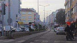
 Fatih Street, the main road of Havsa | |
| Coordinates: 41°32′57″N 26°49′18″E / 41.54917°N 26.82167°E | |
| Country | Turkey |
| Province | Edirne |
| District | Havsa |
| Government | |
| • Mayor | Huseyin Özden ( CHP) |
| Elevation | 26 m (85 ft) |
| Population (2022)
[1] | 8,702 |
| Time zone | UTC+3 ( TRT) |
| Postal code | 22530 |
| Area code | 0284 |
| Website |
www |
Havsa ( Greek: Νίκη) is a town in Edirne Province of Turkey. It is the seat of Havsa District. [2] Its population is 8,702 (2022). [1] The mayor is Huseyin Özden ( CHP).
Havsa was founded as Nike by Greek colonists. When the empire split into two, the city came under the Byzantine Empire. In 1362, the land was captured by Turks under the leadership of Murat I and the area was named Hosa. After Edirne became the center of the Ottoman Empire, the Rûm population in Hosa abandoned the city and moved to Istanbul and Thessaloniki. After the capture of Constantinople, Turks from Anatolia moved in, making the town Turkish.
The town is 21 kilometers away from Edirne, and 218 kilometers from Istanbul.
The town was called Hosa by the Turks in 1331. After Hafsa Hatun moved to the town, it was called Hafsa. Later, the two names were combined to form the current name Havsa.
- ^ a b "Address-based population registration system (ADNKS) results dated 31 December 2022, Favorite Reports" (XLS). TÜİK. Archived from the original on 4 February 2016. Retrieved 13 March 2023.
- ^ İlçe Belediyesi Archived 2023-03-06 at the Wayback Machine, Turkey Civil Administration Departments Inventory. Retrieved 1 March 2023.
Havsa | |
|---|---|
 Fatih Street, the main road of Havsa | |
| Coordinates: 41°32′57″N 26°49′18″E / 41.54917°N 26.82167°E | |
| Country | Turkey |
| Province | Edirne |
| District | Havsa |
| Government | |
| • Mayor | Huseyin Özden ( CHP) |
| Elevation | 26 m (85 ft) |
| Population (2022)
[1] | 8,702 |
| Time zone | UTC+3 ( TRT) |
| Postal code | 22530 |
| Area code | 0284 |
| Website |
www |
Havsa ( Greek: Νίκη) is a town in Edirne Province of Turkey. It is the seat of Havsa District. [2] Its population is 8,702 (2022). [1] The mayor is Huseyin Özden ( CHP).
Havsa was founded as Nike by Greek colonists. When the empire split into two, the city came under the Byzantine Empire. In 1362, the land was captured by Turks under the leadership of Murat I and the area was named Hosa. After Edirne became the center of the Ottoman Empire, the Rûm population in Hosa abandoned the city and moved to Istanbul and Thessaloniki. After the capture of Constantinople, Turks from Anatolia moved in, making the town Turkish.
The town is 21 kilometers away from Edirne, and 218 kilometers from Istanbul.
The town was called Hosa by the Turks in 1331. After Hafsa Hatun moved to the town, it was called Hafsa. Later, the two names were combined to form the current name Havsa.
- ^ a b "Address-based population registration system (ADNKS) results dated 31 December 2022, Favorite Reports" (XLS). TÜİK. Archived from the original on 4 February 2016. Retrieved 13 March 2023.
- ^ İlçe Belediyesi Archived 2023-03-06 at the Wayback Machine, Turkey Civil Administration Departments Inventory. Retrieved 1 March 2023.

