Hasle | |
|---|---|
 | |
_COA.png) Coat of arms | |
 Hasle  Hasle | |
| Coordinates: 46°59′N 8°3′E / 46.983°N 8.050°E | |
| Country | Switzerland |
| Canton | Lucerne |
| District | Entlebuch |
| Area | |
| • Total | 40.30 km2 (15.56 sq mi) |
| Elevation | 718 m (2,356 ft) |
| Population (31 December 2018)
[2] | |
| • Total | 1,743 |
| • Density | 43/km2 (110/sq mi) |
| Time zone | UTC+01:00 ( Central European Time) |
| • Summer ( DST) | UTC+02:00 ( Central European Summer Time) |
| Postal code(s) | 6166 |
| SFOS number | 1005 |
| ISO 3166 code | CH-LU |
| Surrounded by | Doppleschwand, Entlebuch, Flühli, Romoos, Sarnen (OW), Schüpfheim |
| Website |
www Profile (in German), SFSO statistics |
Hasle is a municipality in the district of Entlebuch in the canton of Lucerne in Switzerland. Hasle is part of the UNESCO Entlebuch Biosphere Reserve since 2001.
History
Hasle is first mentioned in 1236 as Hasile in a letter by Pope Gregory IX to the monastery of Engelberg. [3] Along with other places of the Entlebuch valley, Hasle was brought into the sphere of influence of the city of Lucerne as from 1385. In 1653 the rebellious forces of the Swiss Peasant War gathered at Heiligkreuz above the Hasle in order to swear an oath of allegiance.
Geography
Hasle has an area of 40.3 km2 (15.6 sq mi). Of this area, 50.6% is used for agricultural purposes, while 39.6% is forested. Of the rest of the land, 2.9% is settled (buildings or roads) and the remainder (6.9%) is non-productive (rivers, glaciers or mountains). [4] In the 1997 land survey [update], 39.58% of the total land area was forested. Of the agricultural land, 50.12% is used for farming or pastures, while 0.5% is used for orchards or vine crops. Of the settled areas, 0.87% is covered with buildings, 0.05% is industrial, 0.22% is classed as special developments, 0.12% is parks or greenbelts and 1.59% is transportation infrastructure. Of the unproductive areas, 1.24% is unproductive flowing water (rivers) and 5.71% is other unproductive land. [5]
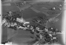
The municipality is located on the both banks of the Kleine Emme. It consists of the linear village of Hasle and the place of pilgrimage/ski resort of Heiligkreuz on the east side of the Emme. On the western side of the river are the hamlets of Habschwanden and Änetegg.
Demographics
Hasle has a population (as of 31 December 2020) of 1,739. [6] As of 2007 [update], 1.2% of the population was made up of foreign nationals. Over the last 10 years the population has decreased at a rate of -5.1%. Most of the population (as of 2000 [update]) speaks German (96.4%), with Albanian being second most common ( 1.9%) and Italian being third ( 0.5%).
In the 2007 election the most popular party was the CVP which received 47.5% of the vote. The next three most popular parties were the SVP (33%), the FDP (13%) and the SPS (4.2%).
The age distribution in Hasle is; 485 people or 28.4% of the population is 0–19 years old. 406 people or 23.8% are 20–39 years old, and 541 people or 31.7% are 40–64 years old. The senior population distribution is 209 people or 12.2% are 65–79 years old, 65 or 3.8% are 80–89 years old and 3 people or 0.2% of the population are 90+ years old. [5]
62.5% of the population (between age 25-64) have completed either non-mandatory upper secondary education or additional higher education (either university or a Fachhochschule).
As of 2000 [update] there are 583 households, 132 of which (about 22.6%) contain only a single individual. 105 or about 18.0% are large households, with at least five members. [5] As of 2000 [update] there were 384 inhabited buildings in the municipality, of which 211 were built only as housing, and 173 were mixed use buildings. There were 142 single family homes, 43 double family homes, and 26 multi-family homes in the municipality. Most homes were either two (140) or three (45) story structures. There were only 14 single story buildings and 12 four or more story buildings. [5]
Hasle has an unemployment rate of 0.76%. As of 2005 [update], there were 299 people employed in the primary economic sector and about 94 businesses involved in this sector. 285 people are employed in the secondary sector and there are 17 businesses in this sector. 221 people are employed in the tertiary sector, with 44 businesses in this sector. [4] As of 2000 [update] 49.3% of the population of the municipality were employed in some capacity. At the same time, females made up 38.1% of the workforce.
According to a census in the year 2000, religious affiliations of the population were as follows: 1,593 inhabitants (93.7%) were Roman Catholic; 54 (3.2%) were Protestant; 8 (0.47%) were of some other Christian faith; 18 (1.06% of the population) were Muslim; 17 (1.0%) did not belong to any organized religion. [5]
The historical population is given in the following table: [3]
| year | population |
|---|---|
| 1650 | 520 |
| 1745 | 1,007 |
| 1837 | 1,626 |
| 1850 | 1,567 |
| 1900 | 1,294 |
| 1950 | 1,535 |
| 2000 | 1,701 |
| 2008 | 1,709 |
References
- ^ a b "Arealstatistik Standard - Gemeinden nach 4 Hauptbereichen". Federal Statistical Office. Retrieved 13 January 2019.
- ^ "Ständige Wohnbevölkerung nach Staatsangehörigkeitskategorie Geschlecht und Gemeinde; Provisorische Jahresergebnisse; 2018". Federal Statistical Office. 9 April 2019. Retrieved 11 April 2019.
- ^ a b Hasle in German, French and Italian in the online Historical Dictionary of Switzerland.
- ^ a b Swiss Federal Statistical Office accessed 17-Aug-2009
- ^ a b c d e LUSTAT Lucerne Cantonal Statistics Archived 2011-11-27 at the Wayback Machine (in German) accessed 12 August 2009
- ^ "Ständige und nichtständige Wohnbevölkerung nach institutionellen Gliederungen, Geburtsort und Staatsangehörigkeit". bfs.admin.ch (in German). Swiss Federal Statistical Office - STAT-TAB. 31 December 2020. Retrieved 21 September 2021.
External links
- Hasle in German, French and Italian in the online Historical Dictionary of Switzerland.
| International | |
|---|---|
| National | |
| Geographic | |
| Other | |
Hasle | |
|---|---|
|
| |
|
Coat of arms | |
Hasle Hasle | |
| Coordinates: 46°59′N 8°3′E / 46.983°N 8.050°E | |
| Country | Switzerland |
| Canton | Lucerne |
| District | Entlebuch |
| Area | |
| • Total | 40.30 km2 (15.56 sq mi) |
| Elevation | 718 m (2,356 ft) |
| Population (31 December 2018)
[2] | |
| • Total | 1,743 |
| • Density | 43/km2 (110/sq mi) |
| Time zone | UTC+01:00 ( Central European Time) |
| • Summer ( DST) | UTC+02:00 ( Central European Summer Time) |
| Postal code(s) | 6166 |
| SFOS number | 1005 |
| ISO 3166 code | CH-LU |
| Surrounded by | Doppleschwand, Entlebuch, Flühli, Romoos, Sarnen (OW), Schüpfheim |
| Website |
www Profile (in German), SFSO statistics |
Hasle is a municipality in the district of Entlebuch in the canton of Lucerne in Switzerland. Hasle is part of the UNESCO Entlebuch Biosphere Reserve since 2001.
History
Hasle is first mentioned in 1236 as Hasile in a letter by Pope Gregory IX to the monastery of Engelberg. [3] Along with other places of the Entlebuch valley, Hasle was brought into the sphere of influence of the city of Lucerne as from 1385. In 1653 the rebellious forces of the Swiss Peasant War gathered at Heiligkreuz above the Hasle in order to swear an oath of allegiance.
Geography
Hasle has an area of 40.3 km2 (15.6 sq mi). Of this area, 50.6% is used for agricultural purposes, while 39.6% is forested. Of the rest of the land, 2.9% is settled (buildings or roads) and the remainder (6.9%) is non-productive (rivers, glaciers or mountains). [4] In the 1997 land survey [update], 39.58% of the total land area was forested. Of the agricultural land, 50.12% is used for farming or pastures, while 0.5% is used for orchards or vine crops. Of the settled areas, 0.87% is covered with buildings, 0.05% is industrial, 0.22% is classed as special developments, 0.12% is parks or greenbelts and 1.59% is transportation infrastructure. Of the unproductive areas, 1.24% is unproductive flowing water (rivers) and 5.71% is other unproductive land. [5]
The municipality is located on the both banks of the Kleine Emme. It consists of the linear village of Hasle and the place of pilgrimage/ski resort of Heiligkreuz on the east side of the Emme. On the western side of the river are the hamlets of Habschwanden and Änetegg.
Demographics
Hasle has a population (as of 31 December 2020) of 1,739. [6] As of 2007 [update], 1.2% of the population was made up of foreign nationals. Over the last 10 years the population has decreased at a rate of -5.1%. Most of the population (as of 2000 [update]) speaks German (96.4%), with Albanian being second most common ( 1.9%) and Italian being third ( 0.5%).
In the 2007 election the most popular party was the CVP which received 47.5% of the vote. The next three most popular parties were the SVP (33%), the FDP (13%) and the SPS (4.2%).
The age distribution in Hasle is; 485 people or 28.4% of the population is 0–19 years old. 406 people or 23.8% are 20–39 years old, and 541 people or 31.7% are 40–64 years old. The senior population distribution is 209 people or 12.2% are 65–79 years old, 65 or 3.8% are 80–89 years old and 3 people or 0.2% of the population are 90+ years old. [5]
62.5% of the population (between age 25-64) have completed either non-mandatory upper secondary education or additional higher education (either university or a Fachhochschule).
As of 2000 [update] there are 583 households, 132 of which (about 22.6%) contain only a single individual. 105 or about 18.0% are large households, with at least five members. [5] As of 2000 [update] there were 384 inhabited buildings in the municipality, of which 211 were built only as housing, and 173 were mixed use buildings. There were 142 single family homes, 43 double family homes, and 26 multi-family homes in the municipality. Most homes were either two (140) or three (45) story structures. There were only 14 single story buildings and 12 four or more story buildings. [5]
Hasle has an unemployment rate of 0.76%. As of 2005 [update], there were 299 people employed in the primary economic sector and about 94 businesses involved in this sector. 285 people are employed in the secondary sector and there are 17 businesses in this sector. 221 people are employed in the tertiary sector, with 44 businesses in this sector. [4] As of 2000 [update] 49.3% of the population of the municipality were employed in some capacity. At the same time, females made up 38.1% of the workforce.
According to a census in the year 2000, religious affiliations of the population were as follows: 1,593 inhabitants (93.7%) were Roman Catholic; 54 (3.2%) were Protestant; 8 (0.47%) were of some other Christian faith; 18 (1.06% of the population) were Muslim; 17 (1.0%) did not belong to any organized religion. [5]
The historical population is given in the following table: [3]
| year | population |
|---|---|
| 1650 | 520 |
| 1745 | 1,007 |
| 1837 | 1,626 |
| 1850 | 1,567 |
| 1900 | 1,294 |
| 1950 | 1,535 |
| 2000 | 1,701 |
| 2008 | 1,709 |
References
- ^ a b "Arealstatistik Standard - Gemeinden nach 4 Hauptbereichen". Federal Statistical Office. Retrieved 13 January 2019.
- ^ "Ständige Wohnbevölkerung nach Staatsangehörigkeitskategorie Geschlecht und Gemeinde; Provisorische Jahresergebnisse; 2018". Federal Statistical Office. 9 April 2019. Retrieved 11 April 2019.
- ^ a b Hasle in German, French and Italian in the online Historical Dictionary of Switzerland.
- ^ a b Swiss Federal Statistical Office accessed 17-Aug-2009
- ^ a b c d e LUSTAT Lucerne Cantonal Statistics Archived 2011-11-27 at the Wayback Machine (in German) accessed 12 August 2009
- ^ "Ständige und nichtständige Wohnbevölkerung nach institutionellen Gliederungen, Geburtsort und Staatsangehörigkeit". bfs.admin.ch (in German). Swiss Federal Statistical Office - STAT-TAB. 31 December 2020. Retrieved 21 September 2021.
External links
- Hasle in German, French and Italian in the online Historical Dictionary of Switzerland.
| International | |
|---|---|
| National | |
| Geographic | |
| Other | |