
Harrisonville is an unincorporated community located at the intersection of U.S. Route 30 and Pennsylvania Route 655 [1] in Licking Creek Township, Fulton County, Pennsylvania, United States. It was named after the ninth U.S. President, William Henry Harrison. Located as a stopping point along the Lincoln Highway, a small country store still serves travelers today. In the 1850s it had two stores, a schoolhouse, one hotel, a blacksmith shop, and seven residents.
References
- ^ PERRY, SPENCE. "Spence Perry: Hagerstown needs more than 30-year-old ideas". Herald-Mail Media. Retrieved February 20, 2024.
External links
Municipalities and communities of
Fulton County, Pennsylvania, United States | ||
|---|---|---|
| Boroughs | 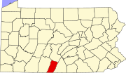 | |
| Townships | ||
| CDP | ||
|
Unincorporated communities | ||
| Footnotes | ‡This populated place also has portions in an adjacent county or counties | |
39°59′15″N 78°03′34″W / 39.98750°N 78.05944°W
|
| This Fulton County, Pennsylvania state location article is a stub. You can help Wikipedia by expanding it. |
Harrisonville is an unincorporated community located at the intersection of U.S. Route 30 and Pennsylvania Route 655 [1] in Licking Creek Township, Fulton County, Pennsylvania, United States. It was named after the ninth U.S. President, William Henry Harrison. Located as a stopping point along the Lincoln Highway, a small country store still serves travelers today. In the 1850s it had two stores, a schoolhouse, one hotel, a blacksmith shop, and seven residents.
References
- ^ PERRY, SPENCE. "Spence Perry: Hagerstown needs more than 30-year-old ideas". Herald-Mail Media. Retrieved February 20, 2024.
External links
Municipalities and communities of
Fulton County, Pennsylvania, United States | ||
|---|---|---|
| Boroughs | | |
| Townships | ||
| CDP | ||
|
Unincorporated communities | ||
| Footnotes | ‡This populated place also has portions in an adjacent county or counties | |
39°59′15″N 78°03′34″W / 39.98750°N 78.05944°W
|
| This Fulton County, Pennsylvania state location article is a stub. You can help Wikipedia by expanding it. |