Photos • Location

Hannasville, Pennsylvania | |
|---|---|
 Westbound
US 322 in Hannasville | |
| Country | United States |
| State | Pennsylvania |
| County | Venango |
| Area | |
| • Total | 1.51 sq mi (3.92 km2) |
| • Land | 1.51 sq mi (3.92 km2) |
| • Water | 0.00 sq mi (0.00 km2) |
| Population | |
| • Total | 159 |
| • Density | 104.95/sq mi (40.52/km2) |
| Time zone | UTC-5 ( Eastern (EST)) |
| • Summer ( DST) | UTC-4 (EDT) |
| FIPS code | 42-32384 |
Hannasville is a census-designated place [3] located in Canal Township, Venango County, in the state of Pennsylvania. The community is located along U.S. Route 322. As of the 2010 census [4] the population was 176.
| Census | Pop. | Note | %± |
|---|---|---|---|
| 2020 | 159 | — | |
| U.S. Decennial Census [5] | |||
- ^ "ArcGIS REST Services Directory". United States Census Bureau. Retrieved October 12, 2022.
- ^ "Census Population API". United States Census Bureau. Retrieved Oct 12, 2022.
-
^
"Archived copy". Archived from
the original on 2015-09-23. Retrieved 2017-12-07.
{{
cite web}}
: CS1 maint: archived copy as title ( link) - ^ https://www.census.gov/# [ not specific enough to verify]
- ^ "Census of Population and Housing". Census.gov. Retrieved June 4, 2016.
Municipalities and communities of
Venango County, Pennsylvania, United States | ||
|---|---|---|
| Cities | 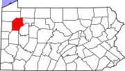 | |
| Boroughs | ||
| Townships | ||
| CDPs | ||
|
Unincorporated communities | ||
| Ghost town | ||
| Footnotes | ‡This populated place also has portions in an adjacent county or counties | |
Hannasville, Pennsylvania | |
|---|---|
|
Westbound
US 322 in Hannasville | |
| Country | United States |
| State | Pennsylvania |
| County | Venango |
| Area | |
| • Total | 1.51 sq mi (3.92 km2) |
| • Land | 1.51 sq mi (3.92 km2) |
| • Water | 0.00 sq mi (0.00 km2) |
| Population | |
| • Total | 159 |
| • Density | 104.95/sq mi (40.52/km2) |
| Time zone | UTC-5 ( Eastern (EST)) |
| • Summer ( DST) | UTC-4 (EDT) |
| FIPS code | 42-32384 |
Hannasville is a census-designated place [3] located in Canal Township, Venango County, in the state of Pennsylvania. The community is located along U.S. Route 322. As of the 2010 census [4] the population was 176.
| Census | Pop. | Note | %± |
|---|---|---|---|
| 2020 | 159 | — | |
| U.S. Decennial Census [5] | |||
- ^ "ArcGIS REST Services Directory". United States Census Bureau. Retrieved October 12, 2022.
- ^ "Census Population API". United States Census Bureau. Retrieved Oct 12, 2022.
-
^
"Archived copy". Archived from
the original on 2015-09-23. Retrieved 2017-12-07.
{{
cite web}}
: CS1 maint: archived copy as title ( link) - ^ https://www.census.gov/# [ not specific enough to verify]
- ^ "Census of Population and Housing". Census.gov. Retrieved June 4, 2016.
Municipalities and communities of
Venango County, Pennsylvania, United States | ||
|---|---|---|
| Cities | | |
| Boroughs | ||
| Townships | ||
| CDPs | ||
|
Unincorporated communities | ||
| Ghost town | ||
| Footnotes | ‡This populated place also has portions in an adjacent county or counties | |