Photos • Location


You can help expand this article with text translated from
the corresponding article in French. (December 2008) Click [show] for important translation instructions.
|
Hérisson | |
|---|---|
 A general view of Hérisson | |
.svg) Coat of arms | |
 Hérisson  Hérisson | |
| Coordinates: 46°30′34″N 2°42′44″E / 46.5094°N 2.7122°E | |
| Country | France |
| Region | Auvergne-Rhône-Alpes |
| Department | Allier |
| Arrondissement | Montluçon |
| Canton | Huriel |
| Intercommunality | CC du Pays de Tronçais |
| Government | |
| • Mayor (2020–2026) | Stéphanie Cusin-Panit [1] |
| Area 1 | 32.57 km2 (12.58 sq mi) |
| Population (2021)
[2] | 583 |
| • Density | 18/km2 (46/sq mi) |
| Time zone | UTC+01:00 ( CET) |
| • Summer ( DST) | UTC+02:00 ( CEST) |
| INSEE/Postal code |
03127 /03190 |
| Elevation | 177–327 m (581–1,073 ft) (avg. 199 m or 653 ft) |
| 1 French Land Register data, which excludes lakes, ponds, glaciers > 1 km2 (0.386 sq mi or 247 acres) and river estuaries. | |
Hérisson (French pronunciation: [eʁisɔ̃]; Occitan: Eiriçon) is a town in the Allier department in central France.
| Year | Pop. | ±% p.a. |
|---|---|---|
| 1968 | 1,043 | — |
| 1975 | 979 | −0.90% |
| 1982 | 872 | −1.64% |
| 1990 | 801 | −1.06% |
| 1999 | 709 | −1.35% |
| 2009 | 662 | −0.68% |
| 2014 | 639 | −0.70% |
| 2020 | 601 | −1.02% |
| Source: INSEE [3] | ||
- Henri Harpignies (28 June 1819 – 28 August 1916), 19th century painter of the Barbizon school who made many pictures of Hérisson and the surroundings.
- Louis Bignon (26 June 1816 - 18 May 1906), restaurateur, who made the Café Riche the most fashionable in Paris.
- Olivier Perrier (born 15 September 1940), actor, codirector of the "Théâtre des Fédérés".
-
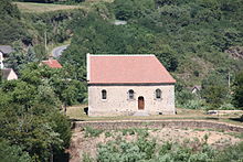
 Church of Notre-Dame
 -
 Chapelle du Calvaire
 -
 Église de Châteloy

.JPG)
_Eglise_de_Chateloy_(2).jpg)
-
 Église de Châteloy: Interior
 -
 Église de Châteloy: Fresco
 -
 Old church of église Saint-Sauveur
 -
 Porte de Varenne
_Eglise_de_Chateloy_(3).jpg)
_Eglise_de_Chateloy_(5).jpg)


- ^ "Répertoire national des élus: les maires". data.gouv.fr, Plateforme ouverte des données publiques françaises (in French). 2 December 2020.
- ^ "Populations légales 2021" (in French). The National Institute of Statistics and Economic Studies. 28 December 2023.
- ^ Population en historique depuis 1968, INSEE
Wikimedia Commons has media related to
Hérisson.
|
| This Allier geographical article is a stub. You can help Wikipedia by expanding it. |
You can help expand this article with text translated from
the corresponding article in French. (December 2008) Click [show] for important translation instructions.
|
Hérisson | |
|---|---|
|
A general view of Hérisson | |
|
Coat of arms | |
Hérisson Hérisson | |
| Coordinates: 46°30′34″N 2°42′44″E / 46.5094°N 2.7122°E | |
| Country | France |
| Region | Auvergne-Rhône-Alpes |
| Department | Allier |
| Arrondissement | Montluçon |
| Canton | Huriel |
| Intercommunality | CC du Pays de Tronçais |
| Government | |
| • Mayor (2020–2026) | Stéphanie Cusin-Panit [1] |
| Area 1 | 32.57 km2 (12.58 sq mi) |
| Population (2021)
[2] | 583 |
| • Density | 18/km2 (46/sq mi) |
| Time zone | UTC+01:00 ( CET) |
| • Summer ( DST) | UTC+02:00 ( CEST) |
| INSEE/Postal code |
03127 /03190 |
| Elevation | 177–327 m (581–1,073 ft) (avg. 199 m or 653 ft) |
| 1 French Land Register data, which excludes lakes, ponds, glaciers > 1 km2 (0.386 sq mi or 247 acres) and river estuaries. | |
Hérisson (French pronunciation: [eʁisɔ̃]; Occitan: Eiriçon) is a town in the Allier department in central France.
| Year | Pop. | ±% p.a. |
|---|---|---|
| 1968 | 1,043 | — |
| 1975 | 979 | −0.90% |
| 1982 | 872 | −1.64% |
| 1990 | 801 | −1.06% |
| 1999 | 709 | −1.35% |
| 2009 | 662 | −0.68% |
| 2014 | 639 | −0.70% |
| 2020 | 601 | −1.02% |
| Source: INSEE [3] | ||
- Henri Harpignies (28 June 1819 – 28 August 1916), 19th century painter of the Barbizon school who made many pictures of Hérisson and the surroundings.
- Louis Bignon (26 June 1816 - 18 May 1906), restaurateur, who made the Café Riche the most fashionable in Paris.
- Olivier Perrier (born 15 September 1940), actor, codirector of the "Théâtre des Fédérés".
-
Church of Notre-Dame
-
Chapelle du Calvaire
-
Église de Châteloy
-
Église de Châteloy: Interior
-
Église de Châteloy: Fresco
-
Old church of église Saint-Sauveur
-
Porte de Varenne
- ^ "Répertoire national des élus: les maires". data.gouv.fr, Plateforme ouverte des données publiques françaises (in French). 2 December 2020.
- ^ "Populations légales 2021" (in French). The National Institute of Statistics and Economic Studies. 28 December 2023.
- ^ Population en historique depuis 1968, INSEE
Wikimedia Commons has media related to
Hérisson.
|
| This Allier geographical article is a stub. You can help Wikipedia by expanding it. |