| Gwaun y Llwyni | |
|---|---|
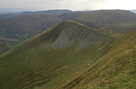
 Gwaun y Llwyni and
Glasgwm (behind) from
Aran Fawddwy | |
| Highest point | |
| Elevation | 685 m (2,247 ft) |
| Prominence | 43 m (141 ft) |
| Parent peak | Aran Fawddwy |
| Listing | Hewitt, Nuttall |
| Naming | |
| Language of name | Welsh |
| Geography | |
| Location | Gwynedd, Wales |
| Parent range | Snowdonia |
| OS grid | SH 85720 20484 |
| Topo map | OS Landranger 124 |
Gwaun y Llwyni is a subsidiary summit of Aran Fawddwy in southern Snowdonia, Wales. It forms a part of the Aran mountain range.
The peak's southern face is very steep and forms one of the backwalls of Cwm Cywarch. The summit is grassy and is marked by a small cairn. Pen yr Allt Uchaf rises on the other side of Cwm Cywarch, Aran Fawddwy is to the north-east, Waun Camddwr to the north and Glasgwm to the west. [1]
References
- ^ Nuttall, John & Anne (1999). The Mountains of England & Wales - Volume 1: Wales (2nd edition ed.). Milnthorpe, Cumbria: Cicerone. ISBN 1-85284-304-7.
External links
52°46′11″N 3°41′43″W / 52.76972°N 3.69528°W
| Gwaun y Llwyni | |
|---|---|
 Gwaun y Llwyni and
Glasgwm (behind) from
Aran Fawddwy | |
| Highest point | |
| Elevation | 685 m (2,247 ft) |
| Prominence | 43 m (141 ft) |
| Parent peak | Aran Fawddwy |
| Listing | Hewitt, Nuttall |
| Naming | |
| Language of name | Welsh |
| Geography | |
| Location | Gwynedd, Wales |
| Parent range | Snowdonia |
| OS grid | SH 85720 20484 |
| Topo map | OS Landranger 124 |
Gwaun y Llwyni is a subsidiary summit of Aran Fawddwy in southern Snowdonia, Wales. It forms a part of the Aran mountain range.
The peak's southern face is very steep and forms one of the backwalls of Cwm Cywarch. The summit is grassy and is marked by a small cairn. Pen yr Allt Uchaf rises on the other side of Cwm Cywarch, Aran Fawddwy is to the north-east, Waun Camddwr to the north and Glasgwm to the west. [1]
References
- ^ Nuttall, John & Anne (1999). The Mountains of England & Wales - Volume 1: Wales (2nd edition ed.). Milnthorpe, Cumbria: Cicerone. ISBN 1-85284-304-7.
External links
52°46′11″N 3°41′43″W / 52.76972°N 3.69528°W