| Guri i Plakës | |
|---|---|
 | |
| Location | Dritan, Drenas, Kosovo |
| Nearest city | Drenas |
| Coordinates | 42°40′27″N 20°57′37″E / 42.67417°N 20.96017°E |
| Area | 0.05 ha |
| Established | 2006 |
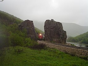
Guri i Plakës is a rock formation near Dritan in the municipality of Drenas. It lies at the foot of Mount Čičavica and was designated a natural monument in 2006 under the category number of MN/034. [1] The meaning of the name Guri I Plakes in English translates to the Old rocks.
History
The rocks are next to the highway from Drenas to Obiliq, and the railway line from Kosovo Polje to Peja runs between them. A single rock was dynamited to make way for the track in 1936. Many myths and legends have arisen around the stones. [2] [3]
Gallery
-
Aerial photograph
-
The stones in winter
References
- ^ RAPORT PËR GJENDJEN E NATYRËS: 2010-2014 (PDF). Pristina: Ministry of Environment and Spatial Planning of Kosovo. 2015. Archived from the original (PDF) on 10 September 2016. Retrieved 6 September 2020.
- ^ "HISTORIKU I STACIONIT HEKURUDHOR TË DRENASIT" (PDF). Hekurudhat e Kosovës: REVISTA PERIODIKE e HEKURUDHAVE TË KOSOVËS Sh.A. (II): 15. September 2010. Retrieved 6 September 2020.
- ^ Mjeku, Bajram (June 23, 2016). "Guri i Plakës, anonimi frëng dhe Beteja e Kosovës". Telegrafi. Retrieved 6 September 2020.
| Guri i Plakës | |
|---|---|
 | |
| Location | Dritan, Drenas, Kosovo |
| Nearest city | Drenas |
| Coordinates | 42°40′27″N 20°57′37″E / 42.67417°N 20.96017°E |
| Area | 0.05 ha |
| Established | 2006 |
Guri i Plakës is a rock formation near Dritan in the municipality of Drenas. It lies at the foot of Mount Čičavica and was designated a natural monument in 2006 under the category number of MN/034. [1] The meaning of the name Guri I Plakes in English translates to the Old rocks.
History
The rocks are next to the highway from Drenas to Obiliq, and the railway line from Kosovo Polje to Peja runs between them. A single rock was dynamited to make way for the track in 1936. Many myths and legends have arisen around the stones. [2] [3]
Gallery
-
Aerial photograph
-
The stones in winter
References
- ^ RAPORT PËR GJENDJEN E NATYRËS: 2010-2014 (PDF). Pristina: Ministry of Environment and Spatial Planning of Kosovo. 2015. Archived from the original (PDF) on 10 September 2016. Retrieved 6 September 2020.
- ^ "HISTORIKU I STACIONIT HEKURUDHOR TË DRENASIT" (PDF). Hekurudhat e Kosovës: REVISTA PERIODIKE e HEKURUDHAVE TË KOSOVËS Sh.A. (II): 15. September 2010. Retrieved 6 September 2020.
- ^ Mjeku, Bajram (June 23, 2016). "Guri i Plakës, anonimi frëng dhe Beteja e Kosovës". Telegrafi. Retrieved 6 September 2020.


