_Together_with_its_Neighboring_Provinces_WDL79.png)

Guillaume Levasseur de Beauplan ( c. 1600 – 6 December 1673) or William le Vasseur de Beauplan was a French-Polish cartographer, engineer and architect.
Beauplan is best known for his maps of Ukraine (which he spelt as Ukranie or Vkranie, with the "U" spelt as a "V"), and his 1660 book Description d'Ukranie ("Description of Ukraine"), first published in 1651 as Description des contrés du Royaume de Pologne ("Description of the Kingdom of Poland's Lands"), which was republished and translated many times in Western European languages throughout the rest of the 17th century and the entire 18th century. [1]
Beauplan served as artillery captain for the army of the Crown of the Kingdom of Poland between 1630 and 1647 or 1648. [2] [3] He was sent to Ukraine where he served under Stanisław Koniecpolski in 1637–1638. He used his architectural skills while in the military. In 1639, he was involved in the rebuilding of the Kodak Fortress. He also built a fortress at Bar, worked on Brody Castle, and structures in Kremenchuk. [3]
In 1639, Beauplan created the first "descriptive" map of Ukraine. [3] He created a map of Ukraine in 1648 that had detailed border information. [2] By 1654 he was working in Danzig. He created a map with a scale of 1:452,000 and an additional map scaled at 1:1,800,000. Both maps were engraved by Willem Hondius. These maps would go on to be published in Rouen, France and reproduced by Veniiamyn Kordt. [3] Beauplan published another map of the Dnieper River in 1662. [3]
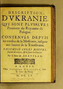
He wrote Description des contrés du Royaume de Pologne, which was published in 1651. [2] It was renamed Description d'Ukranie, when the second, revised edition was released in 1660. [4] The book became the best-known and most frequently re-edited and translated 17th-century source that provided a geographical, economic, cultural, societal and demographic description of Ukraine. [5] In the book, Ukraine was described as a territory between Muscovy and Transylvania. [1] At least 26 editions in at least nine different languages were published from 1651 to 1981. [6] It has seen ongoing prints ever since. [3]
Essar & Pernal (1990) found that the original 1651 edition had two parts: introductory materials and Ukraine. Part 2 about Ukraine discussed the following topics: Kiev (modern Kyiv), the Cossacks (in two chapters), nobles, peasants, other cities and environs, Crimea and the Crimean Tatars, customs, medicine, fauna, and a conclusion. [7] The revised and expanded edition of 1660 had three parts: part 1 had slightly different introductory materials (8 pages); part 2 was about Ukraine (88.5 pages), with added chapters about climate and Easter celebrations; and a new part 3 was added about Poland (24.5 pages, about royal institutions; the Polish nobility; military equipment; banquets; and a conclusion). [8]
Essar & Pernal (1982) found the following 26 editions of Beauplan's Description d'Ukranie, including the original 1651 edition and versions of it:
- Beauplan: Rouen 1651 (French) [9]
- Beauplan: Rouen 1660 (French) [10]
- Beauplan: Rouen 1661 (French) [10]
- Blaeu: Amsterdam 1662 (Latin) [11]
- Blaeu: Amsterdam 1663 (French) [12]
- Blaeu: Amsterdam 1664 (Dutch) [12]
- Blaeu: Amsterdam 1665 (Spanish) [13]
- Blaeu: Amsterdam 1667 (French) [13]
- Blaeu: Amsterdam 1672 (Spanish) [13]
- Beauplan: Rouen 1673 (French) [14]
- Churchill: London 1704 (English) [14]
- Churchill: London 1732 (English) [15]
- Churchill: London 1744 (English) [15]
- Churchill: London 1752 (English) [15]
- Mizler von Kolof: Warsaw 1769 (Latin) [16]
- Moeller: Wrocław 1780 (German) [17]
- Niemcewicz: Warsaw 1822 (Polish) [17]
- Ustrialov: St. Petersburg 1832 (Russian) [17]
- Niemcewicz: Leipzig 1839 (Polish) [18]
- Galitzin: Paris 1861 (French) [18] [19]
- Antonovich: Kiev 1896 (Russian) [20]
- Liaskoronskii: Kiev 1901 (Russian) [20]
- Petryshyn: New York 1959 (English) [20]
- Blaeu: Amsterdam 1967 (French) [6]
- Wójcik: Warsaw 1972 (Polish) [6]
- Isaievych: Lviv 1981 (Ukrainian) [6]
- ^ a b Plokhy 2006, p. 316.
- ^ a b c "General Depiction of the Empty Plains (in Common Parlance, the Ukraine) Together with its Neighboring Provinces". World Digital Library. Retrieved 20 January 2013.
- ^ a b c d e f Borschak, Elie. "Beauplan, Guillaume Le Vasseur de". Internet Encyclopedia of Ukraine. Retrieved 20 January 2013.
- ^ Essar & Pernal 1982, p. 486.
- ^ Essar & Pernal 1990, p. 84.
- ^ a b c d Essar & Pernal 1982, p. 498.
- ^ Essar & Pernal 1990, p. 89.
- ^ Essar & Pernal 1990, pp. 87–89.
- ^ Essar & Pernal 1982, p. 487.
- ^ a b Essar & Pernal 1982, p. 488.
- ^ Essar & Pernal 1982, p. 489.
- ^ a b Essar & Pernal 1982, p. 490.
- ^ a b c Essar & Pernal 1982, p. 491.
- ^ a b Essar & Pernal 1982, p. 492.
- ^ a b c Essar & Pernal 1982, p. 493.
- ^ Essar & Pernal 1982, p. 494.
- ^ a b c Essar & Pernal 1982, p. 495.
- ^ a b Essar & Pernal 1982, p. 496.
-
^ Beauplan, Guillaume Le Vasseur, sieur de (1861).
Description de l'Vkranie depvis les confins de la Moscovie jvsqu'avx limites de la Transylvanie. Paris: J. Techner.
{{
cite book}}
: CS1 maint: multiple names: authors list ( link), Internet Archive - ^ a b c Essar & Pernal 1982, p. 497.
- Essar, D. F.; Pernal, A. B. (1982). "Beauplan's "Description d'Ukranie": A Bibliography of Editions and Translations". Harvard Ukrainian Studies. 6 (4). Harvard Ukrainian Research Institute: 485–499. ISSN 0363-5570. JSTOR 41036007. Retrieved 28 July 2024.
- Essar, Dennis F.; Pernal, Andrew B. (1990). "The First Edition (1651) of Beauplan's Description d'Ukranie". Harvard Ukrainian Studies. 14 (1/2). Harvard Ukrainian Research Institute: 84–96. ISSN 0363-5570. JSTOR 41036356. Retrieved 28 July 2024.
- Plokhy, Serhii (2006). The Origins of the Slavic Nations: Premodern Identities in Russia, Ukraine, and Belarus (PDF). New York: Cambridge University Press. pp. 10–15. ISBN 978-0-521-86403-9. Archived (PDF) from the original on 6 June 2011. Retrieved 27 April 2010.
-
 Media related to
Guillaume le Vasseur de Beauplan at Wikimedia Commons
Media related to
Guillaume le Vasseur de Beauplan at Wikimedia Commons - Guillaume Le Vasseur de Beauplan at WorldCat
- Beauplan's bio at the website of French Ambassador to Ukraine
| International | |
|---|---|
| National | |
| People | |
- 1673 deaths
- People from Dieppe, Seine-Maritime
- 17th-century French architects
- French military engineers
- 17th-century French engineers
- 17th-century French cartographers
- French emigrants
- Immigrants to the Polish–Lithuanian Commonwealth
- Military personnel of the Polish–Lithuanian Commonwealth
- 1600s births
Guillaume Levasseur de Beauplan ( c. 1600 – 6 December 1673) or William le Vasseur de Beauplan was a French-Polish cartographer, engineer and architect.
Beauplan is best known for his maps of Ukraine (which he spelt as Ukranie or Vkranie, with the "U" spelt as a "V"), and his 1660 book Description d'Ukranie ("Description of Ukraine"), first published in 1651 as Description des contrés du Royaume de Pologne ("Description of the Kingdom of Poland's Lands"), which was republished and translated many times in Western European languages throughout the rest of the 17th century and the entire 18th century. [1]
Beauplan served as artillery captain for the army of the Crown of the Kingdom of Poland between 1630 and 1647 or 1648. [2] [3] He was sent to Ukraine where he served under Stanisław Koniecpolski in 1637–1638. He used his architectural skills while in the military. In 1639, he was involved in the rebuilding of the Kodak Fortress. He also built a fortress at Bar, worked on Brody Castle, and structures in Kremenchuk. [3]
In 1639, Beauplan created the first "descriptive" map of Ukraine. [3] He created a map of Ukraine in 1648 that had detailed border information. [2] By 1654 he was working in Danzig. He created a map with a scale of 1:452,000 and an additional map scaled at 1:1,800,000. Both maps were engraved by Willem Hondius. These maps would go on to be published in Rouen, France and reproduced by Veniiamyn Kordt. [3] Beauplan published another map of the Dnieper River in 1662. [3]
He wrote Description des contrés du Royaume de Pologne, which was published in 1651. [2] It was renamed Description d'Ukranie, when the second, revised edition was released in 1660. [4] The book became the best-known and most frequently re-edited and translated 17th-century source that provided a geographical, economic, cultural, societal and demographic description of Ukraine. [5] In the book, Ukraine was described as a territory between Muscovy and Transylvania. [1] At least 26 editions in at least nine different languages were published from 1651 to 1981. [6] It has seen ongoing prints ever since. [3]
Essar & Pernal (1990) found that the original 1651 edition had two parts: introductory materials and Ukraine. Part 2 about Ukraine discussed the following topics: Kiev (modern Kyiv), the Cossacks (in two chapters), nobles, peasants, other cities and environs, Crimea and the Crimean Tatars, customs, medicine, fauna, and a conclusion. [7] The revised and expanded edition of 1660 had three parts: part 1 had slightly different introductory materials (8 pages); part 2 was about Ukraine (88.5 pages), with added chapters about climate and Easter celebrations; and a new part 3 was added about Poland (24.5 pages, about royal institutions; the Polish nobility; military equipment; banquets; and a conclusion). [8]
Essar & Pernal (1982) found the following 26 editions of Beauplan's Description d'Ukranie, including the original 1651 edition and versions of it:
- Beauplan: Rouen 1651 (French) [9]
- Beauplan: Rouen 1660 (French) [10]
- Beauplan: Rouen 1661 (French) [10]
- Blaeu: Amsterdam 1662 (Latin) [11]
- Blaeu: Amsterdam 1663 (French) [12]
- Blaeu: Amsterdam 1664 (Dutch) [12]
- Blaeu: Amsterdam 1665 (Spanish) [13]
- Blaeu: Amsterdam 1667 (French) [13]
- Blaeu: Amsterdam 1672 (Spanish) [13]
- Beauplan: Rouen 1673 (French) [14]
- Churchill: London 1704 (English) [14]
- Churchill: London 1732 (English) [15]
- Churchill: London 1744 (English) [15]
- Churchill: London 1752 (English) [15]
- Mizler von Kolof: Warsaw 1769 (Latin) [16]
- Moeller: Wrocław 1780 (German) [17]
- Niemcewicz: Warsaw 1822 (Polish) [17]
- Ustrialov: St. Petersburg 1832 (Russian) [17]
- Niemcewicz: Leipzig 1839 (Polish) [18]
- Galitzin: Paris 1861 (French) [18] [19]
- Antonovich: Kiev 1896 (Russian) [20]
- Liaskoronskii: Kiev 1901 (Russian) [20]
- Petryshyn: New York 1959 (English) [20]
- Blaeu: Amsterdam 1967 (French) [6]
- Wójcik: Warsaw 1972 (Polish) [6]
- Isaievych: Lviv 1981 (Ukrainian) [6]
- ^ a b Plokhy 2006, p. 316.
- ^ a b c "General Depiction of the Empty Plains (in Common Parlance, the Ukraine) Together with its Neighboring Provinces". World Digital Library. Retrieved 20 January 2013.
- ^ a b c d e f Borschak, Elie. "Beauplan, Guillaume Le Vasseur de". Internet Encyclopedia of Ukraine. Retrieved 20 January 2013.
- ^ Essar & Pernal 1982, p. 486.
- ^ Essar & Pernal 1990, p. 84.
- ^ a b c d Essar & Pernal 1982, p. 498.
- ^ Essar & Pernal 1990, p. 89.
- ^ Essar & Pernal 1990, pp. 87–89.
- ^ Essar & Pernal 1982, p. 487.
- ^ a b Essar & Pernal 1982, p. 488.
- ^ Essar & Pernal 1982, p. 489.
- ^ a b Essar & Pernal 1982, p. 490.
- ^ a b c Essar & Pernal 1982, p. 491.
- ^ a b Essar & Pernal 1982, p. 492.
- ^ a b c Essar & Pernal 1982, p. 493.
- ^ Essar & Pernal 1982, p. 494.
- ^ a b c Essar & Pernal 1982, p. 495.
- ^ a b Essar & Pernal 1982, p. 496.
-
^ Beauplan, Guillaume Le Vasseur, sieur de (1861).
Description de l'Vkranie depvis les confins de la Moscovie jvsqu'avx limites de la Transylvanie. Paris: J. Techner.
{{
cite book}}
: CS1 maint: multiple names: authors list ( link), Internet Archive - ^ a b c Essar & Pernal 1982, p. 497.
- Essar, D. F.; Pernal, A. B. (1982). "Beauplan's "Description d'Ukranie": A Bibliography of Editions and Translations". Harvard Ukrainian Studies. 6 (4). Harvard Ukrainian Research Institute: 485–499. ISSN 0363-5570. JSTOR 41036007. Retrieved 28 July 2024.
- Essar, Dennis F.; Pernal, Andrew B. (1990). "The First Edition (1651) of Beauplan's Description d'Ukranie". Harvard Ukrainian Studies. 14 (1/2). Harvard Ukrainian Research Institute: 84–96. ISSN 0363-5570. JSTOR 41036356. Retrieved 28 July 2024.
- Plokhy, Serhii (2006). The Origins of the Slavic Nations: Premodern Identities in Russia, Ukraine, and Belarus (PDF). New York: Cambridge University Press. pp. 10–15. ISBN 978-0-521-86403-9. Archived (PDF) from the original on 6 June 2011. Retrieved 27 April 2010.
-
Media related to
Guillaume le Vasseur de Beauplan at Wikimedia Commons
- Guillaume Le Vasseur de Beauplan at WorldCat
- Beauplan's bio at the website of French Ambassador to Ukraine
| International | |
|---|---|
| National | |
| People | |
- 1673 deaths
- People from Dieppe, Seine-Maritime
- 17th-century French architects
- French military engineers
- 17th-century French engineers
- 17th-century French cartographers
- French emigrants
- Immigrants to the Polish–Lithuanian Commonwealth
- Military personnel of the Polish–Lithuanian Commonwealth
- 1600s births