Photos • Location

| Gstellihorn | |
|---|---|
 | |
| Highest point | |
| Elevation | 2,855 m (9,367 ft) |
| Prominence | 366 m (1,201 ft) [1] |
| Parent peak | Finsteraarhorn |
| Coordinates | 46°39′43″N 8°10′29.5″E / 46.66194°N 8.174861°E |
| Geography | |
| Location | Bern, Switzerland |
| Parent range | Bernese Alps |
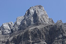
The Gstellihorn (2,855 m) is a mountain of the Bernese Alps, located west of Innertkirchen in the Bernese Oberland. It is the highest summit of the Engelhörner, the chain between the Reichenbachtal and the Urbachtal.
Wikimedia Commons has media related to
Gstellihorn.
| Gstellihorn | |
|---|---|
 | |
| Highest point | |
| Elevation | 2,855 m (9,367 ft) |
| Prominence | 366 m (1,201 ft) [1] |
| Parent peak | Finsteraarhorn |
| Coordinates | 46°39′43″N 8°10′29.5″E / 46.66194°N 8.174861°E |
| Geography | |
| Location | Bern, Switzerland |
| Parent range | Bernese Alps |
The Gstellihorn (2,855 m) is a mountain of the Bernese Alps, located west of Innertkirchen in the Bernese Oberland. It is the highest summit of the Engelhörner, the chain between the Reichenbachtal and the Urbachtal.
Wikimedia Commons has media related to
Gstellihorn.
