Photos • Location

Greenwood, West Virginia | |
|---|---|
 Greenwood  Greenwood | |
| Coordinates: 39°16′29″N 80°53′26″W / 39.27472°N 80.89056°W | |
| Country | |
| State | |
| County | |
| Elevation | 255 m (837 ft) |
| Time zone | UTC-5 ( Eastern (EST)) |
| • Summer ( DST) | UTC-4 (EDT) |
| Area code(s) | 304 & 681 |
| GNIS feature ID | 1554612 [1] |
Greenwood is an unincorporated community in Doddridge County, West Virginia, United States. Greenwood is located along U.S. Route 50, 6.5 miles (10.5 km) west-southwest of West Union.
References
- ^ "US Board on Geographic Names". United States Geological Survey. October 25, 2007. Retrieved January 31, 2008.
Municipalities and communities of
Doddridge County, West Virginia, United States | ||
|---|---|---|
| Town | 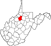 | |
|
Unincorporated communities | ||
|
| This article about a location in Doddridge County, West Virginia is a stub. You can help Wikipedia by expanding it. |
Greenwood, West Virginia | |
|---|---|
Greenwood Greenwood | |
| Coordinates: 39°16′29″N 80°53′26″W / 39.27472°N 80.89056°W | |
| Country | |
| State | |
| County | |
| Elevation | 255 m (837 ft) |
| Time zone | UTC-5 ( Eastern (EST)) |
| • Summer ( DST) | UTC-4 (EDT) |
| Area code(s) | 304 & 681 |
| GNIS feature ID | 1554612 [1] |
Greenwood is an unincorporated community in Doddridge County, West Virginia, United States. Greenwood is located along U.S. Route 50, 6.5 miles (10.5 km) west-southwest of West Union.
References
- ^ "US Board on Geographic Names". United States Geological Survey. October 25, 2007. Retrieved January 31, 2008.
Municipalities and communities of
Doddridge County, West Virginia, United States | ||
|---|---|---|
| Town | | |
|
Unincorporated communities | ||
|
| This article about a location in Doddridge County, West Virginia is a stub. You can help Wikipedia by expanding it. |