
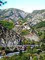
The Gorges de Daluis is a six-kilometer-long canyon formed by the river Var in the Alpes-Maritimes department in southeastern France. It runs south from Guillaumes to Daluis.
Geography
The canyon starts off at Guillaumes, running north to south, west of the Dôme de Barrot, and ends at the small commune of Daluis, where the Var widens. The 6-kilometer-long gorge [1] is cut in the red rock ( sandstone colored by iron oxide, 260 million years old) [2] by the river Var. Notable views along the gorge (a touristic high point [2] and one of a number of "long, lonely canyons" in the area) [3] include the final waterfall of the Clue d'Amen. [4]
Geology and history

The area is dominated by the Dôme de Barrot, 2136 meters high, [2] dating from the Permian. [5] Former copper mining operations in the Dôme are still visible from the gorge, [6] [7] and unique mineral specimens have been found there. [8]
During the Beuil-Guillaumes insurrection of July–August 1944, the Pont de Berthéou was one of two bridges blown up by the French resistance in July 1944 (the Pont du Pra d'Astier on 7 July, the Pont de Berthéou the following day) in an attempt to halt German troops advancing toward Guillaumes. [9]
Environment and tourism

South from Guillaumes, the D902/D2202 runs on the west side of the gorge, with the southbound lane going through 17 tunnels. [10] The (now defunct) Alpes-Maritimes railroad line from Pont-de-Gueydan to Guillaumes, inaugurated in 1923, runs east from Guillaumes and crosses the gorge at the Pont de la Mariée, spanning 58 meters. Bungee jumping is done from the 80-meter-high bridge. [2] [10] Other notable sights include the Tête de la Femme, a rock formation resembling a woman's head on the west side of the road, just north of the Pont de Berthéou, [2] and the gorge is a popular destination for rafting [11] and canoeing. [12] The road along the gorge lends itself to motorcycle [13] and bicycle tourism. [14]
Gallery
-
 Canyoners descend the final waterfall of the Clue d'Amen
 -
 Tête de femme, famous pareidolia also known as La Gardienne des Gorges
 -
 Pont de la Mariée
 -
 The commune of Daluis
 -
 Dôme de Barrot


References
- ^ Eisenschmid, Rainer (2011). Provence, Côte d'Azur. Baedeker. p. 266. ISBN 9783829712606.
- ^ a b c d e Scholl, Reinhard (2002). Französische Seealpen: Alpes-Maritimes: Mercantour - Merveilles; 50 ausgewählte Berg- und Talwanderungen (in German). Bergverlag Rother. pp. 48–55. ISBN 9783763341467.
- ^ Facaros, Dana; Pauls, Michael (2004). Provence. New Holland. p. 254. ISBN 9781860111754.
- ^ de Cessole, M. Victor (1898). "En Hiver: Ascensions dans les Alpes Maritimes". Annuaire (in French). Vol. 24. Club alpin français. pp. 157–72.
-
^ Engelder, Terry (2004). "The Orientation Distribution of Single Joint Sets". In Terry Engelder (ed.).
The Initiation, Propagation, and Arrests of Joints and Other Fractures. J. John W. Cosgrove. Geological Society. pp. 285–98.
ISBN
9781862391659.
Isnard, Marguerite; Isnard, Roger (2006). Nouvel almanach du Comté de Nice: memoria e tradicioun (in French). Serre Editeur. p. 131. ISBN 9782864104612. - ^ Fleury, Jacques (2011). Le plus que passé n'existe pas (in French). Publibook/Société des écrivains. p. 75. ISBN 9782748364330.
- ^ Mari, Gilbert (1992). Les Anciennes mines de cuivre du dôme de Barrot (Alpes-Maritimes) (in French). Serre Editeur. ISBN 9782864101734.
- ^ Delporte, Fréderic (17 August 2006). "Minéralogie des Alpes françaises - Mythe et fascination". Futura-Terre (in French). Retrieved 3 July 2013.
- ^ Girard, Joseph (2006). La Résistance et la Libération de Nice: la fin d'une légende? (in French). Serre Editeur. pp. 71–73. ISBN 9782864104643.
- ^ a b Planet, Lonely; Filou, Emilie; Averbuck, Alexis; John A Vlahides (2012). Lonely Planet Provence & the Cote d'Azur. Lonely Planet. p. 544. ISBN 9781743213766.
- ^ "Descente des Gorges de Daluis en canoë ou en raft" (in French). Retrieved 3 July 2013.
-
^ Novakovich, Mary; Simpson, Louise (2012).
Frommer's Provence and the Riviera. John Wiley & Sons. p. 340.
ISBN
9781118236888.
"Guillaumes visit, photos, travel info and hotels" (in French). Provence Beyond. - ^ "Entrevaux - Gorges de Daluis - Guillaumes - D2202". Motoroutes.net. Retrieved 3 July 2013.
- ^ "Fietsen langs Zuidfranse Gorges Voorbeeldroute Gorges du Cians-Gorges de Daluis, 83 km ±1450m" (in Dutch). Opdefiets.net. Retrieved 3 July 2013.
The Gorges de Daluis is a six-kilometer-long canyon formed by the river Var in the Alpes-Maritimes department in southeastern France. It runs south from Guillaumes to Daluis.
Geography
The canyon starts off at Guillaumes, running north to south, west of the Dôme de Barrot, and ends at the small commune of Daluis, where the Var widens. The 6-kilometer-long gorge [1] is cut in the red rock ( sandstone colored by iron oxide, 260 million years old) [2] by the river Var. Notable views along the gorge (a touristic high point [2] and one of a number of "long, lonely canyons" in the area) [3] include the final waterfall of the Clue d'Amen. [4]
Geology and history
The area is dominated by the Dôme de Barrot, 2136 meters high, [2] dating from the Permian. [5] Former copper mining operations in the Dôme are still visible from the gorge, [6] [7] and unique mineral specimens have been found there. [8]
During the Beuil-Guillaumes insurrection of July–August 1944, the Pont de Berthéou was one of two bridges blown up by the French resistance in July 1944 (the Pont du Pra d'Astier on 7 July, the Pont de Berthéou the following day) in an attempt to halt German troops advancing toward Guillaumes. [9]
Environment and tourism
South from Guillaumes, the D902/D2202 runs on the west side of the gorge, with the southbound lane going through 17 tunnels. [10] The (now defunct) Alpes-Maritimes railroad line from Pont-de-Gueydan to Guillaumes, inaugurated in 1923, runs east from Guillaumes and crosses the gorge at the Pont de la Mariée, spanning 58 meters. Bungee jumping is done from the 80-meter-high bridge. [2] [10] Other notable sights include the Tête de la Femme, a rock formation resembling a woman's head on the west side of the road, just north of the Pont de Berthéou, [2] and the gorge is a popular destination for rafting [11] and canoeing. [12] The road along the gorge lends itself to motorcycle [13] and bicycle tourism. [14]
Gallery
-
Canyoners descend the final waterfall of the Clue d'Amen
-
Tête de femme, famous pareidolia also known as La Gardienne des Gorges
-
Pont de la Mariée
-
The commune of Daluis
-
Dôme de Barrot
References
- ^ Eisenschmid, Rainer (2011). Provence, Côte d'Azur. Baedeker. p. 266. ISBN 9783829712606.
- ^ a b c d e Scholl, Reinhard (2002). Französische Seealpen: Alpes-Maritimes: Mercantour - Merveilles; 50 ausgewählte Berg- und Talwanderungen (in German). Bergverlag Rother. pp. 48–55. ISBN 9783763341467.
- ^ Facaros, Dana; Pauls, Michael (2004). Provence. New Holland. p. 254. ISBN 9781860111754.
- ^ de Cessole, M. Victor (1898). "En Hiver: Ascensions dans les Alpes Maritimes". Annuaire (in French). Vol. 24. Club alpin français. pp. 157–72.
-
^ Engelder, Terry (2004). "The Orientation Distribution of Single Joint Sets". In Terry Engelder (ed.).
The Initiation, Propagation, and Arrests of Joints and Other Fractures. J. John W. Cosgrove. Geological Society. pp. 285–98.
ISBN
9781862391659.
Isnard, Marguerite; Isnard, Roger (2006). Nouvel almanach du Comté de Nice: memoria e tradicioun (in French). Serre Editeur. p. 131. ISBN 9782864104612. - ^ Fleury, Jacques (2011). Le plus que passé n'existe pas (in French). Publibook/Société des écrivains. p. 75. ISBN 9782748364330.
- ^ Mari, Gilbert (1992). Les Anciennes mines de cuivre du dôme de Barrot (Alpes-Maritimes) (in French). Serre Editeur. ISBN 9782864101734.
- ^ Delporte, Fréderic (17 August 2006). "Minéralogie des Alpes françaises - Mythe et fascination". Futura-Terre (in French). Retrieved 3 July 2013.
- ^ Girard, Joseph (2006). La Résistance et la Libération de Nice: la fin d'une légende? (in French). Serre Editeur. pp. 71–73. ISBN 9782864104643.
- ^ a b Planet, Lonely; Filou, Emilie; Averbuck, Alexis; John A Vlahides (2012). Lonely Planet Provence & the Cote d'Azur. Lonely Planet. p. 544. ISBN 9781743213766.
- ^ "Descente des Gorges de Daluis en canoë ou en raft" (in French). Retrieved 3 July 2013.
-
^ Novakovich, Mary; Simpson, Louise (2012).
Frommer's Provence and the Riviera. John Wiley & Sons. p. 340.
ISBN
9781118236888.
"Guillaumes visit, photos, travel info and hotels" (in French). Provence Beyond. - ^ "Entrevaux - Gorges de Daluis - Guillaumes - D2202". Motoroutes.net. Retrieved 3 July 2013.
- ^ "Fietsen langs Zuidfranse Gorges Voorbeeldroute Gorges du Cians-Gorges de Daluis, 83 km ±1450m" (in Dutch). Opdefiets.net. Retrieved 3 July 2013.