Photos • Location
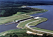
Glover Wilkins Lock and Dam on the Tennessee-Tombigbee Waterway at Smithville, Mississippi


The Glover Wilkins Lock (formerly named Lock B) is a lock of the Tennessee-Tombigbee Waterway. It is located close to Smithville, Mississippi. [1] It was named for Glover Wilkins.
References
- ^ "Glover Wilkins Lock and Dam in Monroe County, MS". Indianapolis Star. Retrieved 23 September 2022.
34°3′53.54″N 88°25′33.19″W / 34.0648722°N 88.4258861°W
|
| This Monroe County, Mississippi state location article is a stub. You can help Wikipedia by expanding it. |