.svg)
Gitanae or Gitana ( Ancient Greek: Γίτανα), or Gitona (Γίτωνα), or Titana (Τίτανα or Τιτάνα), was a city of ancient Epirus, [1] described by Livy as being near Corcyra, and about 10 miles from the coast. [2] as a place of meeting of the Epirote League (Concillio Epirotarum). It is not mentioned by any other ancient writer, and it was conjectured that the word is a corrupt form of Chyton, which Ephorus spoke of as a place in Epirus colonised by Ionians from Klazomenai.
However, its site has been located as the place bearing the modern name Gkoumani, near the village of Fragma Kalama in Greece. [3] [4] [5]
Gallery
-
 Ancient Theater at the archaeological site of Gitanae
 -
 Mosaic depicting the Vergina Sun at the archaeological site of Gitanae
 -
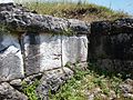 Gitanae walls
 -
 Theater seats with name inscriptions written on them


See also
References
- ^ An Inventory of Archaic and Classical Poleis: An Investigation Conducted by The Copenhagen Polis Centre for the Danish National Research Foundation by Mogens Herman Hansen, 2005, page 345
- ^ Livy. Ab urbe condita Libri [History of Rome]. Vol. xlii. 38.
- ^ Richard Talbert, ed. (2000). Barrington Atlas of the Greek and Roman World. Princeton University Press. p. 54, and directory notes accompanying. ISBN 978-0-691-03169-9.
- ^ Lund University. Digital Atlas of the Roman Empire.
- ^ "Γεφύρι Της Γκούμανης | Τα Πέτρινα Γεφύρια της Ελλάδος". petrinagefiria.com. Retrieved 2021-07-04.
![]() This article incorporates text from a publication now in the
public domain:
Smith, William, ed. (1854–1857). "Gitanae".
Dictionary of Greek and Roman Geography. London: John Murray.
This article incorporates text from a publication now in the
public domain:
Smith, William, ed. (1854–1857). "Gitanae".
Dictionary of Greek and Roman Geography. London: John Murray.
| Authority control databases: Geographic |
|---|
Gitanae or Gitana ( Ancient Greek: Γίτανα), or Gitona (Γίτωνα), or Titana (Τίτανα or Τιτάνα), was a city of ancient Epirus, [1] described by Livy as being near Corcyra, and about 10 miles from the coast. [2] as a place of meeting of the Epirote League (Concillio Epirotarum). It is not mentioned by any other ancient writer, and it was conjectured that the word is a corrupt form of Chyton, which Ephorus spoke of as a place in Epirus colonised by Ionians from Klazomenai.
However, its site has been located as the place bearing the modern name Gkoumani, near the village of Fragma Kalama in Greece. [3] [4] [5]
Gallery
-
Ancient Theater at the archaeological site of Gitanae
-
Mosaic depicting the Vergina Sun at the archaeological site of Gitanae
-
Gitanae walls
-
Theater seats with name inscriptions written on them
See also
References
- ^ An Inventory of Archaic and Classical Poleis: An Investigation Conducted by The Copenhagen Polis Centre for the Danish National Research Foundation by Mogens Herman Hansen, 2005, page 345
- ^ Livy. Ab urbe condita Libri [History of Rome]. Vol. xlii. 38.
- ^ Richard Talbert, ed. (2000). Barrington Atlas of the Greek and Roman World. Princeton University Press. p. 54, and directory notes accompanying. ISBN 978-0-691-03169-9.
- ^ Lund University. Digital Atlas of the Roman Empire.
- ^ "Γεφύρι Της Γκούμανης | Τα Πέτρινα Γεφύρια της Ελλάδος". petrinagefiria.com. Retrieved 2021-07-04.
![]() This article incorporates text from a publication now in the
public domain:
Smith, William, ed. (1854–1857). "Gitanae".
Dictionary of Greek and Roman Geography. London: John Murray.
This article incorporates text from a publication now in the
public domain:
Smith, William, ed. (1854–1857). "Gitanae".
Dictionary of Greek and Roman Geography. London: John Murray.
| Authority control databases: Geographic |
|---|