Greenland is located between the
Arctic Ocean and the North
Atlantic Ocean, northeast of
Canada and northwest of
Iceland. The territory comprises the
island of Greenland—the
largest island in the world—and more than a hundred other smaller islands (see
alphabetic list). Greenland has a 1.2-kilometer-long (0.75 mi) border with Canada on
Hans Island.[1] A sparse population is confined to small settlements along certain sectors of the coast. Greenland possesses the world's second-largest
ice sheet.
Greenland sits atop the
Greenland plate, a subplate of the
North American plate.[2][3] The Greenland
craton is made up of some of the oldest rocks on the face of the earth. The
Isua greenstone belt in southwestern Greenland contains the oldest known rocks on Earth, dated at 3.7–3.8 billion years old.[4]
The vegetation is generally sparse, with the only patch of forested land being found in
Nanortalik Municipality in the extreme south near
Cape Farewell.
Protection of the Arctic environment,
climate change, pollution of the food chain, excessive hunting[5] of endangered species (walrus, polar bears, narwhal, beluga whale and several sea birds).
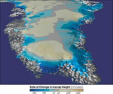
Retreat of the Helheim Glacier, GreenlandMap of Greenland's rate of change in ice sheet heightMap of Greenland bedrock
Greenland's climate is a
tundra climate on and near the coasts and an
ice cap climate in inland areas. It typically has short, cool summers and long, moderately cold winters.
Due to
Gulf Stream influences, Greenland's winter temperatures are very mild for its latitude. In
Nuuk, the capital, average winter temperatures are only −9 °C (16 °F).[6] In comparison, the average winter temperatures for
Iqaluit,
Nunavut,
Canada, are around −27 °C (−17 °F).[7] Conversely, summer temperatures are very low, with an average high around 10 °C (50 °F).[6] This is too low to sustain trees, and the land is treeless
tundra.
On the
Greenland ice sheet, the temperature is far below freezing throughout the year,[8] and record high temperatures have peaked only slightly above freezing. The record high temperature at
Summit Camp is 2.2 °C (36.0 °F).[9]
In the far south of Greenland, there is a very small forest in the
Qinngua Valley, due to summer temperatures being barely high enough to sustain trees. There are mountains over 1,500 metres (4,900 ft) high surrounding the valley, which protect it from cold, fast winds travelling across the ice sheet.[10] It is the only natural forest in Greenland, but is only 15 kilometres (9.3 mi) long.
The Greenland ice sheet is 3 kilometers (1.9 mi) thick and broad enough to blanket an area the size of
Mexico. The ice is so massive that its weight presses the bedrock of Greenland below sea level and is so all-concealing that not until recently did scientists discover
Greenland's Grand Canyon or the possibility that Greenland might actually be three islands.[14]
If the ice melted, the interior bedrock below sea level would be covered by water. It is not clear whether this water would be at sea level or a lake above sea level. If it would be at sea level it could connect to the sea at
Ilulissat Icefjord, in
Baffin Bay and near
Nordostrundingen, creating three large islands.[15] But it is most likely that it would be a lake with one drain.
It is thought that before the
last Ice Age, Greenland had mountainous edges and a lowland (and probably very dry) center which drained to the sea via one big river flowing out westwards, past where
Disko Island is now.[16]
There is concern about
sea level rise caused by ice loss (melt and glaciers falling into the sea) on Greenland. Between 1997 and 2003 ice loss was 68–92 km3/a (16–22 cu mi/a), compared to about 60 km3/a (14 cu mi/a) for 1993/4–1998/9. Half of the increase was from higher summer melting, with the rest caused by the movements of some glaciers exceeding the speeds needed to
balance upstream snow accumulation.[17] A complete loss of ice on Greenland would cause a sea level rise of as much as 6.40 meters (21.0 ft).
Researchers at
NASA's
Jet Propulsion Laboratory and the
University of Kansas reported in February 2006 that the glaciers are melting twice as fast as they were five years ago. By 2005, Greenland was beginning to lose more ice volume than anyone expected – an annual loss of up to 52 cubic miles or 217 cubic kilometres per year, according to more recent satellite gravity measurements released by JPL. The increased ice loss may be partially offset by increased snow accumulation due to increased precipitation.
Between 1991 and 2006, monitoring of the weather at one location (Swiss Camp) found that the average winter temperature had risen almost 10
°F (5.6
°C).
Recently, Greenland's three largest outlet glaciers have started moving faster, satellite data show. These are the
Jakobshavn Isbræ at Ilulissat on the western edge of Greenland, and the
Kangerdlugssuaq and
Helheim glaciers on the eastern edge of Greenland. The two latter accelerated greatly during the years 2004–2005, but returned to pre-2004 velocities in 2006.[18] The accelerating ice flow has been accompanied by a dramatic increase in seismic activity. In March 2006, researchers at
Harvard University and the
Lamont–Doherty Earth Observatory at
Columbia University reported that the glaciers now generate swarms of earthquakes up to magnitude 5.0.[14]
The retreat of Greenland's ice is revealing islands that were thought to be part of the mainland. In September 2005
Dennis Schmitt discovered an island 400 miles (644 km) north of the Arctic Circle in eastern Greenland which he named
Uunartoq Qeqertaq,
Inuit for "warming island".[19]
Future projections
In the
Arctic, temperatures are rising faster than anywhere else in the world. Greenland is losing 200 billion tonnes of ice per year. Research suggests that this could increase the
sea levels' rise by 30 centimeters by the end of the century. These projections have the possibility of changing as satellite data only dates back to 40 years ago. This means that researchers must view old photographs of
glaciers and compare them to ones taken today to determine the future of Greenland's ice.[20]
Temperature extremes
Climate data for Greenland
Month
Jan
Feb
Mar
Apr
May
Jun
Jul
Aug
Sep
Oct
Nov
Dec
Year
Record high °C (°F)
15.3 (59.5)
16.0 (60.8)
16.0 (60.8)
19.1 (66.4)
24.8 (76.6)
30.1 (86.2)
26.3 (79.3)
25.2 (77.4)
24.9 (76.8)
19.3 (66.7)
21.6 (70.9)
15.9 (60.6)
30.1 (86.2)
Record low °C (°F)
−66.1 (−87.0)
−63.3 (−81.9)
−64.8 (−84.6)
−57.3 (−71.1)
−49.0 (−56.2)
−37.5 (−35.5)
−33.0 (−27.4)
−39.2 (−38.6)
−46.0 (−50.8)
−55.4 (−67.7)
−60.0 (−76.0)
−69.6 (−93.3)
−69.6 (−93.3)
Source 1:
Weather Extremes Greenland, retrieved 28 July 2020 (all record lows except for Jan, Mar, May, Dec)(Jan and Feb record highs), Meteo Climat (Mar-Dec highs)
Source 2: Georgi, Johannes (1935),
Eismitte record low, PANGAEA - Data Publisher for Earth & Environmental Science,
doi:
10.1594/PANGAEA.604003, retrieved 28 July 2020 (March record low),
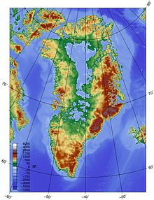
The ice sheet covering Greenland varies significantly in elevation across the landmass, rising dramatically between the coastline at sea level and the East-Central interior, where elevations reach 3,200 meters (10,500 ft).[21] The coastlines are rocky and predominantly barren with fjords.[22] Numerous small islands spread from the Central to Southern coastlines.[22]
Greenland's mountain ranges are partially or completely buried by ice. The highest mountains are in the Watkins Range, which runs along the eastern coast. Greenland's highest mountain is
Gunnbjorn Fjeld with a height of 3,700 meters (12,139 ft).[22]
Scientists discovered an asteroid
impact crater in the northwestern region of Greenland, buried underneath the ice sheet. At a size larger than
Washington, D.C., it is the first impact crater found beneath one of Earth's ice sheets.[23]
Extreme points
This is a list of the extreme points of
Greenland, the points that are farther north, south, east or west than any other location.
Territory of Greenland
Northernmost point —
Kaffeklubben Island (83°40'N) – the
northernmost permanent land in the world. There are also some shifting gravel bars that lie north of Kaffeklubben, the most northerly ever found being
83-42.
Highest point — Gunnbjørn Fjeld, 3,694 meters (12,119 ft).
Towns
Greenland has 17 towns – settlements with more than 500 inhabitants.
Nuuk is the largest town – and the capital – with roughly one third of the country's urban population.
Sisimiut with approximately 5,500 inhabitants is the second largest town, while
Ilulissat is number three with around 5,000 inhabitants.
^"Baffin Bay"(PDF). Indian and Northern Affairs Canada. Archived from
the original(PDF) on 2011-06-13. Retrieved 2009-10-04.
^Appel, Peter W.U., Hugh R. Rollinson, and Jacques L.R. Touret. (2001) "Remnants of an Early Archaean (>3.75 Ga) sea-floor, hydrothermal system in the Isua Greenstone Belt." Precambrian Research, 112.1–2, 15 November, pp. 27–49.
^"Iqaluit A". Canadian Climate Normals 1981–2010.
Environment Canada. 31 October 2011. Climate ID: 2402590.
Archived from the original on May 16, 2017. Retrieved February 24, 2014.
Greenland is located between the
Arctic Ocean and the North
Atlantic Ocean, northeast of
Canada and northwest of
Iceland. The territory comprises the
island of Greenland—the
largest island in the world—and more than a hundred other smaller islands (see
alphabetic list). Greenland has a 1.2-kilometer-long (0.75 mi) border with Canada on
Hans Island.[1] A sparse population is confined to small settlements along certain sectors of the coast. Greenland possesses the world's second-largest
ice sheet.
Greenland sits atop the
Greenland plate, a subplate of the
North American plate.[2][3] The Greenland
craton is made up of some of the oldest rocks on the face of the earth. The
Isua greenstone belt in southwestern Greenland contains the oldest known rocks on Earth, dated at 3.7–3.8 billion years old.[4]
The vegetation is generally sparse, with the only patch of forested land being found in
Nanortalik Municipality in the extreme south near
Cape Farewell.
Protection of the Arctic environment,
climate change, pollution of the food chain, excessive hunting[5] of endangered species (walrus, polar bears, narwhal, beluga whale and several sea birds).
Retreat of the Helheim Glacier, GreenlandMap of Greenland's rate of change in ice sheet heightMap of Greenland bedrock
Greenland's climate is a
tundra climate on and near the coasts and an
ice cap climate in inland areas. It typically has short, cool summers and long, moderately cold winters.
Due to
Gulf Stream influences, Greenland's winter temperatures are very mild for its latitude. In
Nuuk, the capital, average winter temperatures are only −9 °C (16 °F).[6] In comparison, the average winter temperatures for
Iqaluit,
Nunavut,
Canada, are around −27 °C (−17 °F).[7] Conversely, summer temperatures are very low, with an average high around 10 °C (50 °F).[6] This is too low to sustain trees, and the land is treeless
tundra.
On the
Greenland ice sheet, the temperature is far below freezing throughout the year,[8] and record high temperatures have peaked only slightly above freezing. The record high temperature at
Summit Camp is 2.2 °C (36.0 °F).[9]
In the far south of Greenland, there is a very small forest in the
Qinngua Valley, due to summer temperatures being barely high enough to sustain trees. There are mountains over 1,500 metres (4,900 ft) high surrounding the valley, which protect it from cold, fast winds travelling across the ice sheet.[10] It is the only natural forest in Greenland, but is only 15 kilometres (9.3 mi) long.
The Greenland ice sheet is 3 kilometers (1.9 mi) thick and broad enough to blanket an area the size of
Mexico. The ice is so massive that its weight presses the bedrock of Greenland below sea level and is so all-concealing that not until recently did scientists discover
Greenland's Grand Canyon or the possibility that Greenland might actually be three islands.[14]
If the ice melted, the interior bedrock below sea level would be covered by water. It is not clear whether this water would be at sea level or a lake above sea level. If it would be at sea level it could connect to the sea at
Ilulissat Icefjord, in
Baffin Bay and near
Nordostrundingen, creating three large islands.[15] But it is most likely that it would be a lake with one drain.
It is thought that before the
last Ice Age, Greenland had mountainous edges and a lowland (and probably very dry) center which drained to the sea via one big river flowing out westwards, past where
Disko Island is now.[16]
There is concern about
sea level rise caused by ice loss (melt and glaciers falling into the sea) on Greenland. Between 1997 and 2003 ice loss was 68–92 km3/a (16–22 cu mi/a), compared to about 60 km3/a (14 cu mi/a) for 1993/4–1998/9. Half of the increase was from higher summer melting, with the rest caused by the movements of some glaciers exceeding the speeds needed to
balance upstream snow accumulation.[17] A complete loss of ice on Greenland would cause a sea level rise of as much as 6.40 meters (21.0 ft).
Researchers at
NASA's
Jet Propulsion Laboratory and the
University of Kansas reported in February 2006 that the glaciers are melting twice as fast as they were five years ago. By 2005, Greenland was beginning to lose more ice volume than anyone expected – an annual loss of up to 52 cubic miles or 217 cubic kilometres per year, according to more recent satellite gravity measurements released by JPL. The increased ice loss may be partially offset by increased snow accumulation due to increased precipitation.
Between 1991 and 2006, monitoring of the weather at one location (Swiss Camp) found that the average winter temperature had risen almost 10
°F (5.6
°C).
Recently, Greenland's three largest outlet glaciers have started moving faster, satellite data show. These are the
Jakobshavn Isbræ at Ilulissat on the western edge of Greenland, and the
Kangerdlugssuaq and
Helheim glaciers on the eastern edge of Greenland. The two latter accelerated greatly during the years 2004–2005, but returned to pre-2004 velocities in 2006.[18] The accelerating ice flow has been accompanied by a dramatic increase in seismic activity. In March 2006, researchers at
Harvard University and the
Lamont–Doherty Earth Observatory at
Columbia University reported that the glaciers now generate swarms of earthquakes up to magnitude 5.0.[14]
The retreat of Greenland's ice is revealing islands that were thought to be part of the mainland. In September 2005
Dennis Schmitt discovered an island 400 miles (644 km) north of the Arctic Circle in eastern Greenland which he named
Uunartoq Qeqertaq,
Inuit for "warming island".[19]
Future projections
In the
Arctic, temperatures are rising faster than anywhere else in the world. Greenland is losing 200 billion tonnes of ice per year. Research suggests that this could increase the
sea levels' rise by 30 centimeters by the end of the century. These projections have the possibility of changing as satellite data only dates back to 40 years ago. This means that researchers must view old photographs of
glaciers and compare them to ones taken today to determine the future of Greenland's ice.[20]
Temperature extremes
Climate data for Greenland
Month
Jan
Feb
Mar
Apr
May
Jun
Jul
Aug
Sep
Oct
Nov
Dec
Year
Record high °C (°F)
15.3 (59.5)
16.0 (60.8)
16.0 (60.8)
19.1 (66.4)
24.8 (76.6)
30.1 (86.2)
26.3 (79.3)
25.2 (77.4)
24.9 (76.8)
19.3 (66.7)
21.6 (70.9)
15.9 (60.6)
30.1 (86.2)
Record low °C (°F)
−66.1 (−87.0)
−63.3 (−81.9)
−64.8 (−84.6)
−57.3 (−71.1)
−49.0 (−56.2)
−37.5 (−35.5)
−33.0 (−27.4)
−39.2 (−38.6)
−46.0 (−50.8)
−55.4 (−67.7)
−60.0 (−76.0)
−69.6 (−93.3)
−69.6 (−93.3)
Source 1:
Weather Extremes Greenland, retrieved 28 July 2020 (all record lows except for Jan, Mar, May, Dec)(Jan and Feb record highs), Meteo Climat (Mar-Dec highs)
Source 2: Georgi, Johannes (1935),
Eismitte record low, PANGAEA - Data Publisher for Earth & Environmental Science,
doi:
10.1594/PANGAEA.604003, retrieved 28 July 2020 (March record low),
The ice sheet covering Greenland varies significantly in elevation across the landmass, rising dramatically between the coastline at sea level and the East-Central interior, where elevations reach 3,200 meters (10,500 ft).[21] The coastlines are rocky and predominantly barren with fjords.[22] Numerous small islands spread from the Central to Southern coastlines.[22]
Greenland's mountain ranges are partially or completely buried by ice. The highest mountains are in the Watkins Range, which runs along the eastern coast. Greenland's highest mountain is
Gunnbjorn Fjeld with a height of 3,700 meters (12,139 ft).[22]
Scientists discovered an asteroid
impact crater in the northwestern region of Greenland, buried underneath the ice sheet. At a size larger than
Washington, D.C., it is the first impact crater found beneath one of Earth's ice sheets.[23]
Extreme points
This is a list of the extreme points of
Greenland, the points that are farther north, south, east or west than any other location.
Territory of Greenland
Northernmost point —
Kaffeklubben Island (83°40'N) – the
northernmost permanent land in the world. There are also some shifting gravel bars that lie north of Kaffeklubben, the most northerly ever found being
83-42.
Highest point — Gunnbjørn Fjeld, 3,694 meters (12,119 ft).
Towns
Greenland has 17 towns – settlements with more than 500 inhabitants.
Nuuk is the largest town – and the capital – with roughly one third of the country's urban population.
Sisimiut with approximately 5,500 inhabitants is the second largest town, while
Ilulissat is number three with around 5,000 inhabitants.
^"Baffin Bay"(PDF). Indian and Northern Affairs Canada. Archived from
the original(PDF) on 2011-06-13. Retrieved 2009-10-04.
^Appel, Peter W.U., Hugh R. Rollinson, and Jacques L.R. Touret. (2001) "Remnants of an Early Archaean (>3.75 Ga) sea-floor, hydrothermal system in the Isua Greenstone Belt." Precambrian Research, 112.1–2, 15 November, pp. 27–49.
^"Iqaluit A". Canadian Climate Normals 1981–2010.
Environment Canada. 31 October 2011. Climate ID: 2402590.
Archived from the original on May 16, 2017. Retrieved February 24, 2014.

 An enlargeable satellite composite image of Greenland
 Sermeq Kujatdlek Glacier on Greenland's west coast
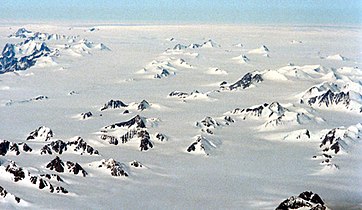 Nunataks on Greenland's east coast
 A polar bear on Greenland's eastern coast
 Small glaciers spilling into a mostly dry valley in western Greenland
 View of deep canyons, or fjords, along the coast of northwestern Greenland
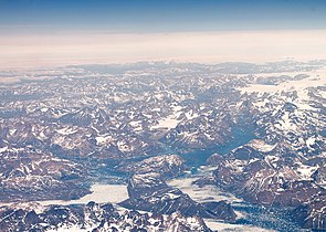 Mountains in southern Greenland, as seen from an altitude of approximately 34,000 feet