Photos • Location
Tilurium remains

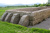
Cemetery, detail


Gardun | |
|---|---|
 Gardun | |
| Coordinates: 43°36′42″N 16°43′05″E / 43.6117°N 16.7181°E | |
| Country | |
| County | Split-Dalmatia |
| City | Trilj |
| Area | |
| • Total | 4.8 km2 (1.9 sq mi) |
| Population (2021)
[2] | |
| • Total | 68 |
| • Density | 14/km2 (37/sq mi) |
| Time zone | UTC+1 ( CET) |
| • Summer ( DST) | UTC+2 ( CEST) |

.jpg)
Gardun is a village at the top of the hill of Gardun, just 1 km south of Trilj.
In the 1997, excavations of the remains of legionary fortress of Tilurium started on the southern outskirts of the village.
Tilurium guarded the entrance to the Cetina valley from the south and the approach to the provincial capital at Salona. [3]
References
- ^ Register of spatial units of the State Geodetic Administration of the Republic of Croatia. Wikidata Q119585703.
- ^ "Population by Age and Sex, by Settlements, 2021 Census". Census of Population, Households and Dwellings in 2021. Zagreb: Croatian Bureau of Statistics. 2022.
- ^ Smith, D., Gaffney, V., Grossman, D., Howard, A.J., Milosevic, A., Ostir, K., Podobnikar, T., Smith, W., Tetlow, E., Tingle, M., and Tinsley, H. 2006. Assessing the later prehistoric environmental archaeology and landscape development of the Cetina Valley, Croatia. Environmental Archaeology 11 (2): 171-186
Wikimedia Commons has media related to
Gardun.
Gardun | |
|---|---|
Gardun | |
| Coordinates: 43°36′42″N 16°43′05″E / 43.6117°N 16.7181°E | |
| Country | |
| County | Split-Dalmatia |
| City | Trilj |
| Area | |
| • Total | 4.8 km2 (1.9 sq mi) |
| Population (2021)
[2] | |
| • Total | 68 |
| • Density | 14/km2 (37/sq mi) |
| Time zone | UTC+1 ( CET) |
| • Summer ( DST) | UTC+2 ( CEST) |
Gardun is a village at the top of the hill of Gardun, just 1 km south of Trilj.
In the 1997, excavations of the remains of legionary fortress of Tilurium started on the southern outskirts of the village.
Tilurium guarded the entrance to the Cetina valley from the south and the approach to the provincial capital at Salona. [3]
References
- ^ Register of spatial units of the State Geodetic Administration of the Republic of Croatia. Wikidata Q119585703.
- ^ "Population by Age and Sex, by Settlements, 2021 Census". Census of Population, Households and Dwellings in 2021. Zagreb: Croatian Bureau of Statistics. 2022.
- ^ Smith, D., Gaffney, V., Grossman, D., Howard, A.J., Milosevic, A., Ostir, K., Podobnikar, T., Smith, W., Tetlow, E., Tingle, M., and Tinsley, H. 2006. Assessing the later prehistoric environmental archaeology and landscape development of the Cetina Valley, Croatia. Environmental Archaeology 11 (2): 171-186
Wikimedia Commons has media related to
Gardun.