| Gantrisch Regional Nature Park | |
|---|---|
| Regionale Naturpark Gantrisch | |
 | |
|
| |
| Type | Regional nature park |
| Location | Bern, Switzerland |
| Nearest city | Schwarzenburg |
| Coordinates | 46°47′N 7°25′E / 46.783°N 7.417°E |
| Area | 414 |
| Website | https://www.gantrisch.ch |


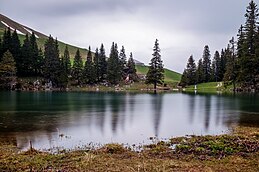
Gantrisch Regional Nature Park is one of 17 parks of national importance in Switzerland. Of its 19 park communities, 18 are in the canton of Bern and one in the canton of Fribourg. [1] [2] The Gantrisch Nature Park covers an area of 414 km² at an altitude between 510 m ( Bern-Belp Airport) and 2239 m ( Schafberg) and includes the Schwarzsee tourist region. [3] [4]
Geography
The Gantrisch Nature Park lies between the three Swiss cities: Bern, Thun and Fribourg and is traversed by the Gürbe, Schwarzwasser and Sense. The park area includes the Längenberg, a lateral moraine of the Aare Glacier, and the Belpberg, which also consists partly of moraine material from the Aare Glacier. In the south, the Gantrisch Nature Park is bordered by the Gantrisch chain, which gives the nature park its name and contains the headwaters of the Gürbe. In the southwest of the nature park is the Schwarzsee and the primeval landscape of Brecca. [3]
19 communities make up the Gantrisch Nature Park (as of 2021): Belp, Burgistein, Forst-Längenbühl, Gerzensee, Guggisberg, Gurzelen, Kaufdorf, Kirchdorf, Niedermuhlern, Oberbalm, Plaffeien, Riggisberg, Rüeggisberg, Rüschegg, Schwarzenburg, Thurnen, Toffen, Wald, Wattenwil. [1]
Landscapes of national importance
In accordance with Article 5 of the Federal Law on the Protection of Nature and Cultural Heritage, Switzerland keeps a Federal Inventory of Landscapes and Natural Monuments. Two of these areas are in the Gantrisch Nature Park: [5]
- No. 1320, designation: Schwarzenburgerland mit Sense- und Schwarzwasser-Schluchten
- No. 1514, designation: Breccaschlund
Sights

Viewpoints
- Guggershörnli
- Monument in honor of Rudolf von Tavel
Museums
- Abegg-Stiftung
- Vreneli-Museum
Historic buildings and facilities
- Schwarzenburg Castle
- Grasburg Castle
- Rüeggisberg Priory
- Gerzensee Castle
- Gerzensee Old Castle
- Gerzensee New Castle
Bodies of water
Mountain peaks
References
- ^ a b "Die Region". Naturpark Gantrisch (in German). Retrieved 2023-08-14.
- ^ "Naturpark Gantrisch – Parkperimeter". 2016-03-04. Archived from the original on 2016-03-04. Retrieved 2023-08-14.
- ^ a b Arnold, Martin (2011). Die Naturpärke in der Schweiz: das grosse Wander- und Erlebnisbuch (in German). AT Verlag. ISBN 978-3-03800-563-6.
- ^ "Naturpark Gantrisch – Kennzahlen des Naturparks Gantrisch". 2015-01-08. Archived from the original on 2015-01-08. Retrieved 2023-08-14.
- ^ "ENHK - Landscapes and natural monuments". 2011-07-06. Archived from the original on 2011-07-06. Retrieved 2023-08-14.
External links
| Gantrisch Regional Nature Park | |
|---|---|
| Regionale Naturpark Gantrisch | |
 | |
|
| |
| Type | Regional nature park |
| Location | Bern, Switzerland |
| Nearest city | Schwarzenburg |
| Coordinates | 46°47′N 7°25′E / 46.783°N 7.417°E |
| Area | 414 |
| Website | https://www.gantrisch.ch |


Gantrisch Regional Nature Park is one of 17 parks of national importance in Switzerland. Of its 19 park communities, 18 are in the canton of Bern and one in the canton of Fribourg. [1] [2] The Gantrisch Nature Park covers an area of 414 km² at an altitude between 510 m ( Bern-Belp Airport) and 2239 m ( Schafberg) and includes the Schwarzsee tourist region. [3] [4]
Geography
The Gantrisch Nature Park lies between the three Swiss cities: Bern, Thun and Fribourg and is traversed by the Gürbe, Schwarzwasser and Sense. The park area includes the Längenberg, a lateral moraine of the Aare Glacier, and the Belpberg, which also consists partly of moraine material from the Aare Glacier. In the south, the Gantrisch Nature Park is bordered by the Gantrisch chain, which gives the nature park its name and contains the headwaters of the Gürbe. In the southwest of the nature park is the Schwarzsee and the primeval landscape of Brecca. [3]
19 communities make up the Gantrisch Nature Park (as of 2021): Belp, Burgistein, Forst-Längenbühl, Gerzensee, Guggisberg, Gurzelen, Kaufdorf, Kirchdorf, Niedermuhlern, Oberbalm, Plaffeien, Riggisberg, Rüeggisberg, Rüschegg, Schwarzenburg, Thurnen, Toffen, Wald, Wattenwil. [1]
Landscapes of national importance
In accordance with Article 5 of the Federal Law on the Protection of Nature and Cultural Heritage, Switzerland keeps a Federal Inventory of Landscapes and Natural Monuments. Two of these areas are in the Gantrisch Nature Park: [5]
- No. 1320, designation: Schwarzenburgerland mit Sense- und Schwarzwasser-Schluchten
- No. 1514, designation: Breccaschlund
Sights

Viewpoints
- Guggershörnli
- Monument in honor of Rudolf von Tavel
Museums
- Abegg-Stiftung
- Vreneli-Museum
Historic buildings and facilities
- Schwarzenburg Castle
- Grasburg Castle
- Rüeggisberg Priory
- Gerzensee Castle
- Gerzensee Old Castle
- Gerzensee New Castle
Bodies of water
Mountain peaks
References
- ^ a b "Die Region". Naturpark Gantrisch (in German). Retrieved 2023-08-14.
- ^ "Naturpark Gantrisch – Parkperimeter". 2016-03-04. Archived from the original on 2016-03-04. Retrieved 2023-08-14.
- ^ a b Arnold, Martin (2011). Die Naturpärke in der Schweiz: das grosse Wander- und Erlebnisbuch (in German). AT Verlag. ISBN 978-3-03800-563-6.
- ^ "Naturpark Gantrisch – Kennzahlen des Naturparks Gantrisch". 2015-01-08. Archived from the original on 2015-01-08. Retrieved 2023-08-14.
- ^ "ENHK - Landscapes and natural monuments". 2011-07-06. Archived from the original on 2011-07-06. Retrieved 2023-08-14.