Māori: Kārewa | |
|---|---|
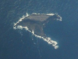
 Aerial view of Gannet Island | |
| Geography | |
| Location | Waikato region |
| Coordinates | 37°58′19″S 174°33′58″E / 37.97194°S 174.56611°E |
| Highest elevation | 15 m (49 ft) |
| Administration | |
New Zealand | |
| Demographics | |
| Population | 0 |
Kārewa / Gannet Island ( Māori: Kārewa) is a small island some 19 kilometres (12 miles) offshore from Kawhia on the west coast of New Zealand's North Island.
The island consists of the eroded remnant of a tuff ring, erupted about half a million years ago. It is considerably younger than, and compositionally distinct from, the nearby onshore Alexandra Volcanics ( Mount Karioi and Mount Pirongia) and Okete Volcanics. It is located on the eastern edge of the North Taranaki Graben, rising 15 metres (49 ft) above sea level from a base about 65 metres (213 ft) deep. [1] In heavy swells the island can be washed over, so that only about 3 square metres (32 sq ft) has vegetation and that limited to Prasiola (algae), Tortula (moss) and Xanthoria, and Xanthoparmelia lichens. [2]
Protected as a wildlife sanctuary, [3] it was found to be the country's largest single breeding colony of Australasian gannets in a 1980 census. [4] Holding about 8000 breeding pairs, the island has been identified as an Important Bird Area, by BirdLife International. [5]
- ^ R. M. Briggs, M. D. Rosenberg, P. J. de Lange, T. Itaya, P. R. King and R. C. Price. (1997). Geology and geochemistry of Gannet (Karewa) Island, Tasman Sea: a rift-related nephelinitic tuff ring, New Zealand Journal of Geology and Geophysics, 40, 263–272.
- ^ "Natural Character Study of the Waikato Coastal Environment SECTION E: OUTSTANDING COASTAL NATURAL CHARACTER" (PDF). Waikato Regional Council. 2016.
- ^ "Wildlife Sanctuary (Gannet Island) Order 1980". Archived from the original on 24 July 2011. Retrieved 29 March 2008.
- ^ Wodzicki, K .; Robertson, C. J. R.; Thompson, H. R.; and Alderton, C. J. T. (1984). The distribution and numbers of gannets (Sula serrator) in New Zealand. Notornis 31, 232–261.
- ^ BirdLife International. (2012). Important Bird Areas factsheet: Gannet Island. Downloaded from "BirdLife International - conserving the world's birds". Archived from the original on 10 July 2007. Retrieved 22 December 2012. on 16 February 2012.
37°58′19″S 174°33′58″E / 37.97194°S 174.56611°E
Māori: Kārewa | |
|---|---|
 Aerial view of Gannet Island | |
| Geography | |
| Location | Waikato region |
| Coordinates | 37°58′19″S 174°33′58″E / 37.97194°S 174.56611°E |
| Highest elevation | 15 m (49 ft) |
| Administration | |
New Zealand | |
| Demographics | |
| Population | 0 |
Kārewa / Gannet Island ( Māori: Kārewa) is a small island some 19 kilometres (12 miles) offshore from Kawhia on the west coast of New Zealand's North Island.
The island consists of the eroded remnant of a tuff ring, erupted about half a million years ago. It is considerably younger than, and compositionally distinct from, the nearby onshore Alexandra Volcanics ( Mount Karioi and Mount Pirongia) and Okete Volcanics. It is located on the eastern edge of the North Taranaki Graben, rising 15 metres (49 ft) above sea level from a base about 65 metres (213 ft) deep. [1] In heavy swells the island can be washed over, so that only about 3 square metres (32 sq ft) has vegetation and that limited to Prasiola (algae), Tortula (moss) and Xanthoria, and Xanthoparmelia lichens. [2]
Protected as a wildlife sanctuary, [3] it was found to be the country's largest single breeding colony of Australasian gannets in a 1980 census. [4] Holding about 8000 breeding pairs, the island has been identified as an Important Bird Area, by BirdLife International. [5]
- ^ R. M. Briggs, M. D. Rosenberg, P. J. de Lange, T. Itaya, P. R. King and R. C. Price. (1997). Geology and geochemistry of Gannet (Karewa) Island, Tasman Sea: a rift-related nephelinitic tuff ring, New Zealand Journal of Geology and Geophysics, 40, 263–272.
- ^ "Natural Character Study of the Waikato Coastal Environment SECTION E: OUTSTANDING COASTAL NATURAL CHARACTER" (PDF). Waikato Regional Council. 2016.
- ^ "Wildlife Sanctuary (Gannet Island) Order 1980". Archived from the original on 24 July 2011. Retrieved 29 March 2008.
- ^ Wodzicki, K .; Robertson, C. J. R.; Thompson, H. R.; and Alderton, C. J. T. (1984). The distribution and numbers of gannets (Sula serrator) in New Zealand. Notornis 31, 232–261.
- ^ BirdLife International. (2012). Important Bird Areas factsheet: Gannet Island. Downloaded from "BirdLife International - conserving the world's birds". Archived from the original on 10 July 2007. Retrieved 22 December 2012. on 16 February 2012.
37°58′19″S 174°33′58″E / 37.97194°S 174.56611°E
