PhotosLocation


gülitz-reetz Latitude and Longitude:

53°12′00″N 11°58′59″E / 53.20000°N 11.98306°E / 53.20000; 11.98306
From Wikipedia, the free encyclopedia
Gülitz-Reetz
Location of Gülitz-Reetz within Prignitz district
Lenzerwische Lenzen (Elbe) Lanz Cumlosen Groß Pankow Pritzwalk Gumtow Plattenburg Legde/Quitzöbel Rühstädt Bad Wilsnack Breese Weisen Wittenberge Perleberg Karstädt Gülitz-Reetz Pirow Berge Putlitz Kümmernitztal Gerdshagen Halenbeck-Rohlsdorf Meyenburg Marienfließ Triglitz Ostprignitz-Ruppin Putlitz Mecklenburg-Vorpommern Saxony-Anhalt Saxony-Anhalt
Gülitz-Reetz is located in Germany
Gülitz-Reetz
Gülitz-Reetz
Gülitz-Reetz is located in Brandenburg
Gülitz-Reetz
Gülitz-Reetz
Coordinates: 53°12′00″N 11°58′59″E / 53.20000°N 11.98306°E / 53.20000; 11.98306
Country Germany
State Brandenburg
District Prignitz
Municipal assoc. Putlitz-Berge
Government
 •  Mayor (2019–24) Detlef Spiegelberg [1]
Area
 • Total24.27 km2 (9.37 sq mi)
Highest elevation
70 m (230 ft)
Lowest elevation
50 m (160 ft)
Population
 (2022-12-31) [2]
 • Total441
 • Density18/km2 (47/sq mi)
Time zone UTC+01:00 ( CET)
 • Summer ( DST) UTC+02:00 ( CEST)
Postal codes
19348
Dialling codes038782
Vehicle registrationPR

Gülitz-Reetz is a municipality in the Prignitz district, in Brandenburg, Germany.

Demography

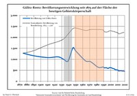
Development of population since 1875 within the current boundaries (Blue line: Population; Dotted line: Comparison to population development of Brandenburg state; Grey background: Time of Nazi rule; Red background: Time of communist rule)
Gülitz-Reetz: Population development
within the current boundaries (2017) [3]
Year Pop. ±% p.a.
1875 1,276—    
1890 1,159−0.64%
1910 1,078−0.36%
1925 1,109+0.19%
1933 990−1.41%
1939 923−1.16%
1946 1,522+7.41%
1950 1,381−2.40%
1964 927−2.81%
1971 893−0.53%
1981 655−3.05%
1985 621−1.32%
1989 651+1.19%
1990 631−3.07%
Year Pop. ±% p.a.
1991 611−3.17%
1992 610−0.16%
1993 616+0.98%
1994 612−0.65%
1995 602−1.63%
1996 580−3.65%
1997 596+2.76%
1998 612+2.68%
1999 619+1.14%
2000 613−0.97%
2001 612−0.16%
2002 596−2.61%
2003 581−2.52%
2004 579−0.34%
Year Pop. ±% p.a.
2005 565−2.42%
2006 539−4.60%
2007 523−2.97%
2008 523+0.00%
2009 512−2.10%
2010 514+0.39%
2011 475−7.59%
2012 465−2.11%
2013 481+3.44%
2014 476−1.04%
2015 479+0.63%
2016 468−2.30%
2017 461−1.50%

References

  1. ^ Landkreis Prignitz Wahl der Bürgermeisterin / des Bürgermeisters, accessed 2 July 2021.
  2. ^ "Bevölkerungsentwicklung und Bevölkerungsstandim Land Brandenburg Dezember 2022" (PDF). Amt für Statistik Berlin-Brandenburg (in German). June 2023.
  3. ^ Detailed data sources are to be found in the Wikimedia Commons. Population Projection Brandenburg at Wikimedia Commons

gülitz-reetz Latitude and Longitude:

53°12′00″N 11°58′59″E / 53.20000°N 11.98306°E / 53.20000; 11.98306
From Wikipedia, the free encyclopedia
Gülitz-Reetz
Location of Gülitz-Reetz within Prignitz district
Lenzerwische Lenzen (Elbe) Lanz Cumlosen Groß Pankow Pritzwalk Gumtow Plattenburg Legde/Quitzöbel Rühstädt Bad Wilsnack Breese Weisen Wittenberge Perleberg Karstädt Gülitz-Reetz Pirow Berge Putlitz Kümmernitztal Gerdshagen Halenbeck-Rohlsdorf Meyenburg Marienfließ Triglitz Ostprignitz-Ruppin Putlitz Mecklenburg-Vorpommern Saxony-Anhalt Saxony-Anhalt
Gülitz-Reetz is located in Germany
Gülitz-Reetz
Gülitz-Reetz
Gülitz-Reetz is located in Brandenburg
Gülitz-Reetz
Gülitz-Reetz
Coordinates: 53°12′00″N 11°58′59″E / 53.20000°N 11.98306°E / 53.20000; 11.98306
Country Germany
State Brandenburg
District Prignitz
Municipal assoc. Putlitz-Berge
Government
 •  Mayor (2019–24) Detlef Spiegelberg [1]
Area
 • Total24.27 km2 (9.37 sq mi)
Highest elevation
70 m (230 ft)
Lowest elevation
50 m (160 ft)
Population
 (2022-12-31) [2]
 • Total441
 • Density18/km2 (47/sq mi)
Time zone UTC+01:00 ( CET)
 • Summer ( DST) UTC+02:00 ( CEST)
Postal codes
19348
Dialling codes038782
Vehicle registrationPR

Gülitz-Reetz is a municipality in the Prignitz district, in Brandenburg, Germany.

Demography

Development of population since 1875 within the current boundaries (Blue line: Population; Dotted line: Comparison to population development of Brandenburg state; Grey background: Time of Nazi rule; Red background: Time of communist rule)
Gülitz-Reetz: Population development
within the current boundaries (2017) [3]
Year Pop. ±% p.a.
1875 1,276—    
1890 1,159−0.64%
1910 1,078−0.36%
1925 1,109+0.19%
1933 990−1.41%
1939 923−1.16%
1946 1,522+7.41%
1950 1,381−2.40%
1964 927−2.81%
1971 893−0.53%
1981 655−3.05%
1985 621−1.32%
1989 651+1.19%
1990 631−3.07%
Year Pop. ±% p.a.
1991 611−3.17%
1992 610−0.16%
1993 616+0.98%
1994 612−0.65%
1995 602−1.63%
1996 580−3.65%
1997 596+2.76%
1998 612+2.68%
1999 619+1.14%
2000 613−0.97%
2001 612−0.16%
2002 596−2.61%
2003 581−2.52%
2004 579−0.34%
Year Pop. ±% p.a.
2005 565−2.42%
2006 539−4.60%
2007 523−2.97%
2008 523+0.00%
2009 512−2.10%
2010 514+0.39%
2011 475−7.59%
2012 465−2.11%
2013 481+3.44%
2014 476−1.04%
2015 479+0.63%
2016 468−2.30%
2017 461−1.50%

References

  1. ^ Landkreis Prignitz Wahl der Bürgermeisterin / des Bürgermeisters, accessed 2 July 2021.
  2. ^ "Bevölkerungsentwicklung und Bevölkerungsstandim Land Brandenburg Dezember 2022" (PDF). Amt für Statistik Berlin-Brandenburg (in German). June 2023.
  3. ^ Detailed data sources are to be found in the Wikimedia Commons. Population Projection Brandenburg at Wikimedia Commons

Videos

Youtube | Vimeo | Bing

Websites

Google | Yahoo | Bing

Encyclopedia

Google | Yahoo | Bing

Facebook