Photos • Location
| Gäbris | |
|---|---|
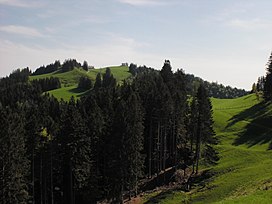
 View from the west side | |
| Highest point | |
| Elevation | 1,251 m (4,104 ft) |
| Prominence | 367 m (1,204 ft) [1] |
| Parent peak | Säntis |
| Coordinates | 47°22′54″N 9°28′04″E / 47.38167°N 9.46778°E |
| Geography | |
| Location | Appenzell Ausserrhoden, Switzerland |
| Parent range | Appenzell Alps |
Gäbris is a mountain of the Appenzell Alps, overlooking Gais in the canton of Appenzell Ausserrhoden.
References
External links
| Gäbris | |
|---|---|
 View from the west side | |
| Highest point | |
| Elevation | 1,251 m (4,104 ft) |
| Prominence | 367 m (1,204 ft) [1] |
| Parent peak | Säntis |
| Coordinates | 47°22′54″N 9°28′04″E / 47.38167°N 9.46778°E |
| Geography | |
| Location | Appenzell Ausserrhoden, Switzerland |
| Parent range | Appenzell Alps |
Gäbris is a mountain of the Appenzell Alps, overlooking Gais in the canton of Appenzell Ausserrhoden.
References
External links
