Fraile | |
|---|---|
Barrio | |
 Boy on pier in Fraile | |
 | |
 Fraile | |
| Coordinates: 18°17′51″N 65°15′00″W / 18.297476°N 65.25013°W [1] | |
| Commonwealth | |
| Municipality | |
| Area | |
| • Total | 35.41 sq mi (91.7 km2) |
| • Land | 3.18 sq mi (8.2 km2) |
| • Water | 32.23 sq mi (83.5 km2) |
| Elevation | 0 ft (0 m) |
| Population (2010) | |
| • Total | 42 |
| • Density | 13.2/sq mi (5.1/km2) |
| Source: 2010 Census | |
| Time zone | UTC−4 ( AST) |
| ZIP Code | 00775 |
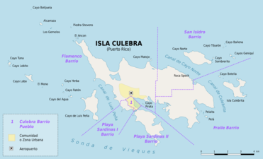
Fraile is a barrio in the island-municipality of Culebra, Puerto Rico. Its population in 2010 was 42. [3] [4] [5]
| Census | Pop. | Note | %± |
|---|---|---|---|
| 1930 | 87 | — | |
| 1940 | 134 | 54.0% | |
| 1950 | 89 | −33.6% | |
| 1960 | 18 | −79.8% | |
| 1970 | 8 | −55.6% | |
| 1980 | 9 | 12.5% | |
| 1990 | 22 | 144.4% | |
| 2000 | 51 | 131.8% | |
| 2010 | 42 | −17.6% | |
| U.S. Decennial Census 1899 (shown as 1900) [6] 1910-1930 [7] 1930-1950 [8] 1980-2000 [9] 2010 [10] | |||
Sectors
Barrios (which are, in contemporary times, roughly comparable to minor civil divisions) [11] in turn are further subdivided into smaller local populated place areas/units called sectores (sectors in English). The types of sectores may vary, from normally sector to urbanización to reparto to barriada to residencial, among others. [12] [13] [14]
Culebrita is a small island which is part of Fraile barrio.
The following sectors are in Fraile barrio: [15]
Condominio Costa Bonita, Extensión Barriada Clark, Sector Alturas de Soni, Sector Carenero, and Sector Las Vacas.
Gallery
-
 View of Fraile
 -
 Zoni Beach in Fraile barrio, on Northeastern coast of Culebra
 -


See also
References
- ^ a b "US Gazetteer 2019". US Census. US Government.
- ^ U.S. Geological Survey Geographic Names Information System: Fraile, Culebra, Puerto Rico
- ^ Picó, Rafael; Buitrago de Santiago, Zayda; Berrios, Hector H. Nueva geografía de Puerto Rico: física, económica, y social, por Rafael Picó. Con la colaboración de Zayda Buitrago de Santiago y Héctor H. Berrios. San Juan Editorial Universitaria, Universidad de Puerto Rico,1969.
- ^ Gwillim Law (20 May 2015). Administrative Subdivisions of Countries: A Comprehensive World Reference, 1900 through 1998. McFarland. p. 300. ISBN 978-1-4766-0447-3. Retrieved 25 December 2018.
- ^ Puerto Rico: 2010 Population and Housing Unit Counts.pdf (PDF). U.S. Dept. of Commerce, Economics and Statistics Administration, U.S. Census Bureau. 2010.
- ^ "Report of the Census of Porto Rico 1899". War Department Office Director Census of Porto Rico. Archived from the original on July 16, 2017. Retrieved September 21, 2017.
- ^ "Table 3-Population of Municipalities: 1930 1920 and 1910" (PDF). United States Census Bureau. Archived (PDF) from the original on August 17, 2017. Retrieved September 21, 2017.
- ^ "Table 4-Area and Population of Municipalities Urban and Rural: 1930 to 1950" (PDF). United States Census Bureau. Archived (PDF) from the original on August 30, 2015. Retrieved September 21, 2014.
- ^ "Table 2 Population and Housing Units: 1960 to 2000" (PDF). United States Census Bureau. Archived (PDF) from the original on July 24, 2017. Retrieved September 21, 2017.
- ^ Puerto Rico: 2010 Population and Housing Unit Counts.pdf (PDF). U.S. Dept. of Commerce Economics and Statistics Administration U.S. Census Bureau. 2010. Archived (PDF) from the original on 2017-02-20. Retrieved 2019-08-02.
- ^ "US Census Barrio-Pueblo definition". factfinder.com. US Census. Archived from the original on 13 May 2017. Retrieved 5 January 2019.
- ^ "Agencia: Oficina del Coordinador General para el Financiamiento Socioeconómico y la Autogestión (Proposed 2016 Budget)". Puerto Rico Budgets (in Spanish). Retrieved 28 June 2019.
- ^ Rivera Quintero, Marcia (2014), El vuelo de la esperanza: Proyecto de las Comunidades Especiales Puerto Rico, 1997-2004 (first ed.), San Juan, Puerto Rico Fundación Sila M. Calderón, ISBN 978-0-9820806-1-0
- ^ "Leyes del 2001". Lex Juris Puerto Rico (in Spanish). Retrieved 24 June 2020.
- ^ "PRECINTO ELECTORAL CULEBRA 097" (PDF). Comisión Estatal de Elecciones (in Spanish). PR Government. 7 November 2018. Archived from the original (PDF) on 25 June 2020. Retrieved 24 June 2020.
|
| This Culebra, Puerto Rico location article is a stub. You can help Wikipedia by expanding it. |
Fraile | |
|---|---|
Barrio | |
|
Boy on pier in Fraile | |
|
| |
Fraile | |
| Coordinates: 18°17′51″N 65°15′00″W / 18.297476°N 65.25013°W [1] | |
| Commonwealth | |
| Municipality | |
| Area | |
| • Total | 35.41 sq mi (91.7 km2) |
| • Land | 3.18 sq mi (8.2 km2) |
| • Water | 32.23 sq mi (83.5 km2) |
| Elevation | 0 ft (0 m) |
| Population (2010) | |
| • Total | 42 |
| • Density | 13.2/sq mi (5.1/km2) |
| Source: 2010 Census | |
| Time zone | UTC−4 ( AST) |
| ZIP Code | 00775 |
Fraile is a barrio in the island-municipality of Culebra, Puerto Rico. Its population in 2010 was 42. [3] [4] [5]
| Census | Pop. | Note | %± |
|---|---|---|---|
| 1930 | 87 | — | |
| 1940 | 134 | 54.0% | |
| 1950 | 89 | −33.6% | |
| 1960 | 18 | −79.8% | |
| 1970 | 8 | −55.6% | |
| 1980 | 9 | 12.5% | |
| 1990 | 22 | 144.4% | |
| 2000 | 51 | 131.8% | |
| 2010 | 42 | −17.6% | |
| U.S. Decennial Census 1899 (shown as 1900) [6] 1910-1930 [7] 1930-1950 [8] 1980-2000 [9] 2010 [10] | |||
Sectors
Barrios (which are, in contemporary times, roughly comparable to minor civil divisions) [11] in turn are further subdivided into smaller local populated place areas/units called sectores (sectors in English). The types of sectores may vary, from normally sector to urbanización to reparto to barriada to residencial, among others. [12] [13] [14]
Culebrita is a small island which is part of Fraile barrio.
The following sectors are in Fraile barrio: [15]
Condominio Costa Bonita, Extensión Barriada Clark, Sector Alturas de Soni, Sector Carenero, and Sector Las Vacas.
Gallery
-
View of Fraile
-
Zoni Beach in Fraile barrio, on Northeastern coast of Culebra
-
See also
References
- ^ a b "US Gazetteer 2019". US Census. US Government.
- ^ U.S. Geological Survey Geographic Names Information System: Fraile, Culebra, Puerto Rico
- ^ Picó, Rafael; Buitrago de Santiago, Zayda; Berrios, Hector H. Nueva geografía de Puerto Rico: física, económica, y social, por Rafael Picó. Con la colaboración de Zayda Buitrago de Santiago y Héctor H. Berrios. San Juan Editorial Universitaria, Universidad de Puerto Rico,1969.
- ^ Gwillim Law (20 May 2015). Administrative Subdivisions of Countries: A Comprehensive World Reference, 1900 through 1998. McFarland. p. 300. ISBN 978-1-4766-0447-3. Retrieved 25 December 2018.
- ^ Puerto Rico: 2010 Population and Housing Unit Counts.pdf (PDF). U.S. Dept. of Commerce, Economics and Statistics Administration, U.S. Census Bureau. 2010.
- ^ "Report of the Census of Porto Rico 1899". War Department Office Director Census of Porto Rico. Archived from the original on July 16, 2017. Retrieved September 21, 2017.
- ^ "Table 3-Population of Municipalities: 1930 1920 and 1910" (PDF). United States Census Bureau. Archived (PDF) from the original on August 17, 2017. Retrieved September 21, 2017.
- ^ "Table 4-Area and Population of Municipalities Urban and Rural: 1930 to 1950" (PDF). United States Census Bureau. Archived (PDF) from the original on August 30, 2015. Retrieved September 21, 2014.
- ^ "Table 2 Population and Housing Units: 1960 to 2000" (PDF). United States Census Bureau. Archived (PDF) from the original on July 24, 2017. Retrieved September 21, 2017.
- ^ Puerto Rico: 2010 Population and Housing Unit Counts.pdf (PDF). U.S. Dept. of Commerce Economics and Statistics Administration U.S. Census Bureau. 2010. Archived (PDF) from the original on 2017-02-20. Retrieved 2019-08-02.
- ^ "US Census Barrio-Pueblo definition". factfinder.com. US Census. Archived from the original on 13 May 2017. Retrieved 5 January 2019.
- ^ "Agencia: Oficina del Coordinador General para el Financiamiento Socioeconómico y la Autogestión (Proposed 2016 Budget)". Puerto Rico Budgets (in Spanish). Retrieved 28 June 2019.
- ^ Rivera Quintero, Marcia (2014), El vuelo de la esperanza: Proyecto de las Comunidades Especiales Puerto Rico, 1997-2004 (first ed.), San Juan, Puerto Rico Fundación Sila M. Calderón, ISBN 978-0-9820806-1-0
- ^ "Leyes del 2001". Lex Juris Puerto Rico (in Spanish). Retrieved 24 June 2020.
- ^ "PRECINTO ELECTORAL CULEBRA 097" (PDF). Comisión Estatal de Elecciones (in Spanish). PR Government. 7 November 2018. Archived from the original (PDF) on 25 June 2020. Retrieved 24 June 2020.
|
| This Culebra, Puerto Rico location article is a stub. You can help Wikipedia by expanding it. |