_historical_marker.JPG)
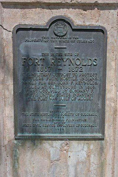
Fort Reynolds was a United States Army post near Avondale, Colorado during the Indian Wars and the Civil War. [1] [2] [3] The site is about 20 miles (32 km) east of Pueblo, Colorado. [2]
Construction began in 1867 on the 23 square mile fort, which was named for John F. Reynolds. He attended West Point and was killed at the Battle of Gettysburg. [2] Facilities included barracks, a mess hall, hospital, guardhouse, store-house, laundry, a corral, supply depot, and parade grounds. [2] [4] Fort Lyon, which lies 60 miles (97 km) east of Fort Reynolds was closer to the skirmishes with Native Americans, so Fort Reynolds became a supply post, staffed with about 100 soldiers. [2] In January 1868, soldiers were called from Fort Lyon and Fort Reynolds to manage citizen unrest in Trinidad, Colorado that began with a drunken brawl. That was the extent of the action seen by the Fort Reynolds post. It closed in 1872. [2]
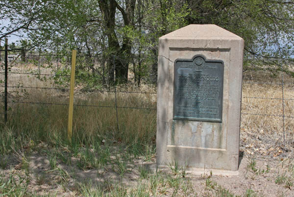
In the 1930s, the site had remnants of camp life, including cooking utensils, weapons, buttons, and other items. [1] A stone marker is located on US-50 at mile marker 333, about one mile east of Avondale. [2]
References
- ^ a b Federal Writers' Project (October 31, 2013). The WPA Guide to Colorado: The Highest State. Trinity University Press. p. PT296. ISBN 978-1-59534-205-8.
- ^ a b c d e f g Jolie Anderson Gallagher (April 2, 2013). Colorado Forts: Historic Outposts on the Wild Frontier. Arcadia Publishing Incorporated. p. PT113, other pages. ISBN 978-1-61423-903-1.
- ^ U.S. Geological Survey Geographic Names Information System: Fort Reynolds (Colorado)
- ^ United States. Quartermaster's Dept (1872). Outline Description of U.S. Military Posts and Stations in the Year 1871. U.S. Government Printing Office. p. 208, 264.
External links
38°13′50.33″N 104°18′11.82″W / 38.2306472°N 104.3032833°W
| Overview | |||||||||
|---|---|---|---|---|---|---|---|---|---|
| Trading posts and civilian forts |
| ||||||||
| U.S. and Spanish military forts |
| ||||||||
| Related articles | |||||||||
Fort Reynolds was a United States Army post near Avondale, Colorado during the Indian Wars and the Civil War. [1] [2] [3] The site is about 20 miles (32 km) east of Pueblo, Colorado. [2]
Construction began in 1867 on the 23 square mile fort, which was named for John F. Reynolds. He attended West Point and was killed at the Battle of Gettysburg. [2] Facilities included barracks, a mess hall, hospital, guardhouse, store-house, laundry, a corral, supply depot, and parade grounds. [2] [4] Fort Lyon, which lies 60 miles (97 km) east of Fort Reynolds was closer to the skirmishes with Native Americans, so Fort Reynolds became a supply post, staffed with about 100 soldiers. [2] In January 1868, soldiers were called from Fort Lyon and Fort Reynolds to manage citizen unrest in Trinidad, Colorado that began with a drunken brawl. That was the extent of the action seen by the Fort Reynolds post. It closed in 1872. [2]
In the 1930s, the site had remnants of camp life, including cooking utensils, weapons, buttons, and other items. [1] A stone marker is located on US-50 at mile marker 333, about one mile east of Avondale. [2]
References
- ^ a b Federal Writers' Project (October 31, 2013). The WPA Guide to Colorado: The Highest State. Trinity University Press. p. PT296. ISBN 978-1-59534-205-8.
- ^ a b c d e f g Jolie Anderson Gallagher (April 2, 2013). Colorado Forts: Historic Outposts on the Wild Frontier. Arcadia Publishing Incorporated. p. PT113, other pages. ISBN 978-1-61423-903-1.
- ^ U.S. Geological Survey Geographic Names Information System: Fort Reynolds (Colorado)
- ^ United States. Quartermaster's Dept (1872). Outline Description of U.S. Military Posts and Stations in the Year 1871. U.S. Government Printing Office. p. 208, 264.
External links
38°13′50.33″N 104°18′11.82″W / 38.2306472°N 104.3032833°W
| Overview | |||||||||
|---|---|---|---|---|---|---|---|---|---|
| Trading posts and civilian forts |
| ||||||||
| U.S. and Spanish military forts |
| ||||||||
| Related articles | |||||||||