| Fort Louis | |
|---|---|
| Marigot, Saint Martin | |
 Remains of Fort Louis, with French flag | |
 Fort Louis  Fort Louis | |
| Coordinates | 18°04′15″N 63°05′07″W / 18.070774°N 63.085404°W |
| Type | Fortification |
| Site information | |
| Open to the public | Yes |
| Condition | Ruins |
| Site history | |
| Built | 1789 |
| In use | No |
| Materials | Stone |
Fort Louis (or Fort St. Louis) [1] [2] is a historic French military fort on the Caribbean island of Saint Martin. It is located in Marigot, the capital of the French side of the island, overlooking Marigot Bay. [3] The fort was built in the 18th century to defend Marigot's harbor and its warehouses. [4] It was built during the reign of King Louis XVI.
History
By 1765, batteries of canons were set up in three locations to defend Marigot's harbor: on the cliff of Pointe Bluff (pointe de Bluff), on Round Hill (Morne Rond), and on Marigot Hill (Morne de Marigot). [5] A 1775 report written by Auguste Descoudrelles, [5] commander of Saint Martin and Saint Barthélemy at that time, said that a fort on Marigot Hill would have helped Saint Martin defend its port, [6] as the island had been prone to raids by the English. [7]
In 1789, Jean-Sébastien de Durat, subsequent commander of Saint Martin and Saint Barthélemy, oversaw the construction of a fort, a prison, and a bridge in Marigot, [5] under the orders of King Louis the XVI. The fort was built at the location of the Marigot Hill battery. Its purpose was to defend the warehouses in Marigot's harbor below, where local crops (such as coffee, salt, rum, and cane sugar) were stored. [4] [5] Durat named the fort Fort Louis, [5] likely after Louis XVI, the French king he served under.
Originally Fort Louis was a wooden fort. [8] By the beginning of the 19th century, the fort extended down the slopes of Marigot Hill with the construction of two additional batteries. [8] While the fort was active, it had barracks for 54 troops. [1] It had a guard room, a kitchen, and cistern. [1]
It is possible that the fort was occupied by English troops while the English occupied the island of Saint Martin in 1781-1783, 1794, 1800 and 1810-1815. [8] [9] However, no evidence of English occupation of the fort has been found. [8]
In 1851, the fort was abandoned and decommissioned by the military. [1]
Preservation
Between 1993 and 1994, restoration and enhancement work was undertaken by the Hope Estate Archaeological Association of Saint Martin (L'Association Archeologique Hope Estate), in cooperation the Military Service of Guadeloupe as well as the Departmental Archives in Basse-Terre, the National Overseas Archives in Aix-en-Provence. [5] [6]
Gallery
-
 Fort entrance
 -
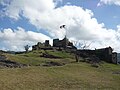
 Fort summit, with French flag
 -
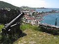 Canon, with view of Marigot Market and harbor below
 -
 Embrasure and canon
 -
 Exterior wall of Fort Louis
 -
 Fort Louis at the top of Marigot Hill
.jpg)
.jpg)
.jpg)
.jpg)


References
- ^ a b c d Hartog, Johannes (1981). History of Sint Maarten and Saint Martin. Sint Maarten Jaycees.
- ^ Reid, Basil A.; III, R. Grant Gilmore (2014-03-04). Encyclopedia of Caribbean Archaeology. University Press of Florida. ISBN 978-0-8130-4853-6.
- ^ Stanford, Emma; Hanna, Nick (2016-10-04). National Geographic Traveler - The Caribbean: Ports of Call and Beyond. National Geographic Books. p. 176. ISBN 978-1-4262-1709-8.
- ^ a b "Fort Louis". St-Martin.org (in French). Tourist Office of Saint Martin, Tourist Information Bureau. Retrieved 2023-09-11.
- ^ a b c d e f Association Archeologique Hope Estate Bulletin Annuel 1993 (in French). Archeologie Saint Martin FWI.
- ^ a b Association Archeologique Hope Estate Bulletin Annuel 1994 (in French). Archeologie Saint Martin FWI.
- ^ Davenport, Frances Gardiner; Paullin, Charles Oscar (1917). European Treaties Bearing on the History of the United States and Its Dependencies. Carnegie Institution of Washington. p. 353.
- ^ a b c d Barthélémy-Moizan, Emmanuel (2018-12-01). "Poubelles de militaires". Archéopages. Archéologie et société (in French) (46): 108–109. ISSN 1622-8545.
- ^ Duffy, Michael (1998). "World-Wide War and British Expansion, 1793–1815". In Marshall, P. J. (ed.). The Oxford History of the British Empire: Volume II: The Eighteenth Century. Oxford University Press. ISBN 9780198205630.
| Fort Louis | |
|---|---|
| Marigot, Saint Martin | |
|
Remains of Fort Louis, with French flag | |
Fort Louis Fort Louis | |
| Coordinates | 18°04′15″N 63°05′07″W / 18.070774°N 63.085404°W |
| Type | Fortification |
| Site information | |
| Open to the public | Yes |
| Condition | Ruins |
| Site history | |
| Built | 1789 |
| In use | No |
| Materials | Stone |
Fort Louis (or Fort St. Louis) [1] [2] is a historic French military fort on the Caribbean island of Saint Martin. It is located in Marigot, the capital of the French side of the island, overlooking Marigot Bay. [3] The fort was built in the 18th century to defend Marigot's harbor and its warehouses. [4] It was built during the reign of King Louis XVI.
History
By 1765, batteries of canons were set up in three locations to defend Marigot's harbor: on the cliff of Pointe Bluff (pointe de Bluff), on Round Hill (Morne Rond), and on Marigot Hill (Morne de Marigot). [5] A 1775 report written by Auguste Descoudrelles, [5] commander of Saint Martin and Saint Barthélemy at that time, said that a fort on Marigot Hill would have helped Saint Martin defend its port, [6] as the island had been prone to raids by the English. [7]
In 1789, Jean-Sébastien de Durat, subsequent commander of Saint Martin and Saint Barthélemy, oversaw the construction of a fort, a prison, and a bridge in Marigot, [5] under the orders of King Louis the XVI. The fort was built at the location of the Marigot Hill battery. Its purpose was to defend the warehouses in Marigot's harbor below, where local crops (such as coffee, salt, rum, and cane sugar) were stored. [4] [5] Durat named the fort Fort Louis, [5] likely after Louis XVI, the French king he served under.
Originally Fort Louis was a wooden fort. [8] By the beginning of the 19th century, the fort extended down the slopes of Marigot Hill with the construction of two additional batteries. [8] While the fort was active, it had barracks for 54 troops. [1] It had a guard room, a kitchen, and cistern. [1]
It is possible that the fort was occupied by English troops while the English occupied the island of Saint Martin in 1781-1783, 1794, 1800 and 1810-1815. [8] [9] However, no evidence of English occupation of the fort has been found. [8]
In 1851, the fort was abandoned and decommissioned by the military. [1]
Preservation
Between 1993 and 1994, restoration and enhancement work was undertaken by the Hope Estate Archaeological Association of Saint Martin (L'Association Archeologique Hope Estate), in cooperation the Military Service of Guadeloupe as well as the Departmental Archives in Basse-Terre, the National Overseas Archives in Aix-en-Provence. [5] [6]
Gallery
-
Fort entrance
-
Fort summit, with French flag
-
Canon, with view of Marigot Market and harbor below
-
Embrasure and canon
-
Exterior wall of Fort Louis
-
Fort Louis at the top of Marigot Hill
References
- ^ a b c d Hartog, Johannes (1981). History of Sint Maarten and Saint Martin. Sint Maarten Jaycees.
- ^ Reid, Basil A.; III, R. Grant Gilmore (2014-03-04). Encyclopedia of Caribbean Archaeology. University Press of Florida. ISBN 978-0-8130-4853-6.
- ^ Stanford, Emma; Hanna, Nick (2016-10-04). National Geographic Traveler - The Caribbean: Ports of Call and Beyond. National Geographic Books. p. 176. ISBN 978-1-4262-1709-8.
- ^ a b "Fort Louis". St-Martin.org (in French). Tourist Office of Saint Martin, Tourist Information Bureau. Retrieved 2023-09-11.
- ^ a b c d e f Association Archeologique Hope Estate Bulletin Annuel 1993 (in French). Archeologie Saint Martin FWI.
- ^ a b Association Archeologique Hope Estate Bulletin Annuel 1994 (in French). Archeologie Saint Martin FWI.
- ^ Davenport, Frances Gardiner; Paullin, Charles Oscar (1917). European Treaties Bearing on the History of the United States and Its Dependencies. Carnegie Institution of Washington. p. 353.
- ^ a b c d Barthélémy-Moizan, Emmanuel (2018-12-01). "Poubelles de militaires". Archéopages. Archéologie et société (in French) (46): 108–109. ISSN 1622-8545.
- ^ Duffy, Michael (1998). "World-Wide War and British Expansion, 1793–1815". In Marshall, P. J. (ed.). The Oxford History of the British Empire: Volume II: The Eighteenth Century. Oxford University Press. ISBN 9780198205630.