| Fort Cooper State Park | |
|---|---|
 | |
  | |
| Location | Citrus County, Florida, United States |
| Nearest city | Inverness, Florida |
| Coordinates | 28°48′36″N 82°18′19″W / 28.81000°N 82.30528°W |
| Area | 710 acres (2.9 km2) |
| Established | June 13, 1972 |
| Governing body | Florida Department of Environmental Protection |
Fort Cooper State Park is a 710-acre historic site in Inverness, Florida, United States. It is located two miles (3 km) south of Inverness, off of U.S. Hwy. 41 on South Old Floral City Road. On June 13, 1972, it was added to the United States National Register of Historic Places. It is also a Florida State Park.
Among the wildlife of the park are white-tailed deer, wild turkey, opossum, bobcat, owls, herons and cardinals.
The park features an annual re-enactment during March of the Second Seminole War. [1] Activities include fishing, swimming, sunbathing, youth camping, canoeing, hiking, boat tours, and nature viewing. The park is also accessible from the Withlacoochee State Trail.
Amenities include access to 160-acre (0.65 km2) Lake Holathlikaha, a swimming area, paddleboat and canoe rentals, a picnic and playground area, and nearly 5 miles (8.0 km) of hiking trails. The park also has nature trails, a beach, and a primitive campground.
Florida state parks are open between 8 a.m. and sundown every day of the year (including holidays).
-
 Fort Cooper
 -
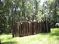 Fort Cooper site
 -
 Entrance to the park from Withlacoochee State Trail


- ^ "FORT COOPER DAYS (MARCH)". Discover Crystal River Florida. Citrus County Visitors and Convention Bureau. Retrieved 22 February 2022.
- Fort Cooper State Park at Florida State Parks
- Citrus County listings at National Register of Historic Places
- Citrus County listings at Florida's Office of Cultural and Historical Programs
- Fort Cooper State Park at Absolutely Florida
| Lists by county |
|  |
|---|---|---|
| Lists by city | ||
| Other lists | ||
|
| This article about a property in Citrus County, Florida on the National Register of Historic Places is a stub. You can help Wikipedia by expanding it. |
|
| This Florida State Park related article is a stub. You can help Wikipedia by expanding it. |
|
| This military base or fortification article is a stub. You can help Wikipedia by expanding it. |
- IUCN Category III
- 1972 establishments in Florida
- Florida Native American Heritage Trail
- Forts on the National Register of Historic Places in Florida
- National Register of Historic Places in Citrus County, Florida
- Parks on the National Register of Historic Places in Florida
- Parks in Citrus County, Florida
- Protected areas established in 1972
- Second Seminole War fortifications
- State parks of Florida
- Central Florida Registered Historic Place stubs
- Florida state park stubs
- Fortification stubs
| Fort Cooper State Park | |
|---|---|
|
| |
| |
| Location | Citrus County, Florida, United States |
| Nearest city | Inverness, Florida |
| Coordinates | 28°48′36″N 82°18′19″W / 28.81000°N 82.30528°W |
| Area | 710 acres (2.9 km2) |
| Established | June 13, 1972 |
| Governing body | Florida Department of Environmental Protection |
Fort Cooper State Park is a 710-acre historic site in Inverness, Florida, United States. It is located two miles (3 km) south of Inverness, off of U.S. Hwy. 41 on South Old Floral City Road. On June 13, 1972, it was added to the United States National Register of Historic Places. It is also a Florida State Park.
Among the wildlife of the park are white-tailed deer, wild turkey, opossum, bobcat, owls, herons and cardinals.
The park features an annual re-enactment during March of the Second Seminole War. [1] Activities include fishing, swimming, sunbathing, youth camping, canoeing, hiking, boat tours, and nature viewing. The park is also accessible from the Withlacoochee State Trail.
Amenities include access to 160-acre (0.65 km2) Lake Holathlikaha, a swimming area, paddleboat and canoe rentals, a picnic and playground area, and nearly 5 miles (8.0 km) of hiking trails. The park also has nature trails, a beach, and a primitive campground.
Florida state parks are open between 8 a.m. and sundown every day of the year (including holidays).
-
Fort Cooper
-
Fort Cooper site
-
Entrance to the park from Withlacoochee State Trail
- ^ "FORT COOPER DAYS (MARCH)". Discover Crystal River Florida. Citrus County Visitors and Convention Bureau. Retrieved 22 February 2022.
- Fort Cooper State Park at Florida State Parks
- Citrus County listings at National Register of Historic Places
- Citrus County listings at Florida's Office of Cultural and Historical Programs
- Fort Cooper State Park at Absolutely Florida
| |||||||||||||||||||||||
| |||||||||||||||||||||||
| |||||||||||||||||||||||
| Lists by county |
| |
|---|---|---|
| Lists by city | ||
| Other lists | ||
|
| This article about a property in Citrus County, Florida on the National Register of Historic Places is a stub. You can help Wikipedia by expanding it. |
|
| This Florida State Park related article is a stub. You can help Wikipedia by expanding it. |
|
| This military base or fortification article is a stub. You can help Wikipedia by expanding it. |
- IUCN Category III
- 1972 establishments in Florida
- Florida Native American Heritage Trail
- Forts on the National Register of Historic Places in Florida
- National Register of Historic Places in Citrus County, Florida
- Parks on the National Register of Historic Places in Florida
- Parks in Citrus County, Florida
- Protected areas established in 1972
- Second Seminole War fortifications
- State parks of Florida
- Central Florida Registered Historic Place stubs
- Florida state park stubs
- Fortification stubs