| Foel Hafod-fynydd | |
|---|---|
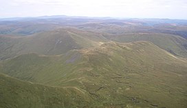
 Foel Hafod-fynydd from
Aran Fawddwy with
Esgeiriau Gwynion (behind left) and
Llechwedd Du (behind right) | |
| Highest point | |
| Elevation | 689 m (2,260 ft) |
| Prominence | 84 m (276 ft) |
| Parent peak | Aran Fawddwy |
| Listing | Hewitt, Nuttall |
| Naming | |
| Language of name | Welsh |
| Geography | |
| Location | Gwynedd, Wales |
| Parent range | Snowdonia |
| OS grid | SH8770922722 |
| Topo map | OS Landranger 124 |
Foel Hafod-fynydd is a subsidiary summit of Aran Fawddwy in southern Snowdonia, North Wales, Wales, United Kingdom. It tops the east ridge of Erw y Ddafad-ddu. Creiglyn Dyfi nestles in the bowl between Foel Hafod-fynydd and Aran Fawddwy.
The summit is grassy marked by a few stones. Esgeiriau Gwynion lies to the north, Llechwedd Du to the east, and Gwaun Lydan to the south. [1]
- ^ Nuttall, John & Anne (1999). The Mountains of England & Wales - Volume 1: Wales (2nd edition ed.). Milnthorpe, Cumbria: Cicerone. ISBN 1-85284-304-7.
52°47′25″N 3°39′54″W / 52.790139°N 3.66506°W
| Foel Hafod-fynydd | |
|---|---|
 Foel Hafod-fynydd from
Aran Fawddwy with
Esgeiriau Gwynion (behind left) and
Llechwedd Du (behind right) | |
| Highest point | |
| Elevation | 689 m (2,260 ft) |
| Prominence | 84 m (276 ft) |
| Parent peak | Aran Fawddwy |
| Listing | Hewitt, Nuttall |
| Naming | |
| Language of name | Welsh |
| Geography | |
| Location | Gwynedd, Wales |
| Parent range | Snowdonia |
| OS grid | SH8770922722 |
| Topo map | OS Landranger 124 |
Foel Hafod-fynydd is a subsidiary summit of Aran Fawddwy in southern Snowdonia, North Wales, Wales, United Kingdom. It tops the east ridge of Erw y Ddafad-ddu. Creiglyn Dyfi nestles in the bowl between Foel Hafod-fynydd and Aran Fawddwy.
The summit is grassy marked by a few stones. Esgeiriau Gwynion lies to the north, Llechwedd Du to the east, and Gwaun Lydan to the south. [1]
- ^ Nuttall, John & Anne (1999). The Mountains of England & Wales - Volume 1: Wales (2nd edition ed.). Milnthorpe, Cumbria: Cicerone. ISBN 1-85284-304-7.
52°47′25″N 3°39′54″W / 52.790139°N 3.66506°W