Fjordgård
Fjordgard | |
|---|---|
Village | |
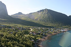
 View of the village | |
| Coordinates: 69°30′28″N 17°37′43″E / 69.50778°N 17.62861°E | |
| Country | Norway |
| Region | Northern Norway |
| County | Troms |
| District | Midt-Troms |
| Municipality | Senja Municipality |
| Elevation | 9 m (30 ft) |
| Time zone | UTC+01:00 ( CET) |
| • Summer ( DST) | UTC+02:00 ( CEST) |
| Post Code | 9388 Fjordgård |
Fjordgård or Fjordgard is a small fishing village in Senja Municipality in Troms county, Norway. It is located on the northern part of the island of Senja, the second largest island in Norway. Fjordgård lies on the west side of the fjord Ørnfjorden, which is an arm that branches off of the main Øyfjorden. The island village of Husøy lies about 4 kilometres (2.5 mi) across the fjord within sight of Fjordgård. [2]
Fjordgård is surrounded by high and steep mountains and is connected to the rest of the island of Senja by a series of three road tunnels. Its population (2001) is 213. [3] Fjordgård Chapel is located in the village.
Cultural references
In Book 4 of Karl Ove Knausgård's internationally popular My Struggle novels, Karl Ove teaches at the local school in Fjordgård. The village is referred to in the book by the pseudonym "Håfjord." [4]
References
- ^ "Fjordgård" (in Norwegian). yr.no. Retrieved 2012-12-05.
- ^ Store norske leksikon. "Fjordgard" (in Norwegian). Retrieved 2012-12-05.
-
^
Statistisk sentralbyrå (2001).
"Folke- og boligtellingen 2001, kommune- og bydelshefter 1931 Lenvik" (PDF) (in Norwegian).
{{
cite journal}}
: Cite journal requires|journal=( help) - ^ Kristensen, Eivind (2010-02-10). "Her er Knausgårds hemmelige skole". Dagbladet (in Norwegian).
Fjordgård
Fjordgard | |
|---|---|
Village | |
 View of the village | |
| Coordinates: 69°30′28″N 17°37′43″E / 69.50778°N 17.62861°E | |
| Country | Norway |
| Region | Northern Norway |
| County | Troms |
| District | Midt-Troms |
| Municipality | Senja Municipality |
| Elevation | 9 m (30 ft) |
| Time zone | UTC+01:00 ( CET) |
| • Summer ( DST) | UTC+02:00 ( CEST) |
| Post Code | 9388 Fjordgård |
Fjordgård or Fjordgard is a small fishing village in Senja Municipality in Troms county, Norway. It is located on the northern part of the island of Senja, the second largest island in Norway. Fjordgård lies on the west side of the fjord Ørnfjorden, which is an arm that branches off of the main Øyfjorden. The island village of Husøy lies about 4 kilometres (2.5 mi) across the fjord within sight of Fjordgård. [2]
Fjordgård is surrounded by high and steep mountains and is connected to the rest of the island of Senja by a series of three road tunnels. Its population (2001) is 213. [3] Fjordgård Chapel is located in the village.
Cultural references
In Book 4 of Karl Ove Knausgård's internationally popular My Struggle novels, Karl Ove teaches at the local school in Fjordgård. The village is referred to in the book by the pseudonym "Håfjord." [4]
References
- ^ "Fjordgård" (in Norwegian). yr.no. Retrieved 2012-12-05.
- ^ Store norske leksikon. "Fjordgard" (in Norwegian). Retrieved 2012-12-05.
-
^
Statistisk sentralbyrå (2001).
"Folke- og boligtellingen 2001, kommune- og bydelshefter 1931 Lenvik" (PDF) (in Norwegian).
{{
cite journal}}
: Cite journal requires|journal=( help) - ^ Kristensen, Eivind (2010-02-10). "Her er Knausgårds hemmelige skole". Dagbladet (in Norwegian).

