| Fish River (Namibia) | |
|---|---|
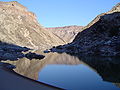
 The Fish River in August during winter. | |
 The Fish River Basin | |
| Location | |
| Country | Namibia |
| Physical characteristics | |
| Source | |
| • location | Near Mariental |
| Mouth | Orange River |
| Length | 650 km (400 mi) |
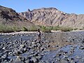
The Fish River (Visrivier in Afrikaans, Fischfluss in German) is a river in Namibia. It is 650 km long, flowing from the Naukluft Mountains [1] 150 km to the Hardap Dam near Mariental. From there the flow is entirely blocked, [1] all further flow downstream coming from tributaries downstream from the dam. The flow of the river is seasonal; in winter the river can dry up completely. Despite this, the river is the site of the spectacular Fish River Canyon, a canyon 160 km long, and at points as much as 550 m deep.
The outflow of the Fish River joins the Orange River at the border with South Africa about 100 km from the Atlantic Ocean.
-
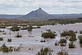
 Fish River crossing
 -

-
-
-


References
- ^ a b "Fish River Canyon". Archived from the original on 2019-04-08.
| International | |
|---|---|
| National | |
28°08′S 17°11′E / 28.133°S 17.183°E
| Fish River (Namibia) | |
|---|---|
|
The Fish River in August during winter. | |
|
The Fish River Basin | |
| Location | |
| Country | Namibia |
| Physical characteristics | |
| Source | |
| • location | Near Mariental |
| Mouth | Orange River |
| Length | 650 km (400 mi) |
The Fish River (Visrivier in Afrikaans, Fischfluss in German) is a river in Namibia. It is 650 km long, flowing from the Naukluft Mountains [1] 150 km to the Hardap Dam near Mariental. From there the flow is entirely blocked, [1] all further flow downstream coming from tributaries downstream from the dam. The flow of the river is seasonal; in winter the river can dry up completely. Despite this, the river is the site of the spectacular Fish River Canyon, a canyon 160 km long, and at points as much as 550 m deep.
The outflow of the Fish River joins the Orange River at the border with South Africa about 100 km from the Atlantic Ocean.
-
Fish River crossing
-
-
-
-
References
- ^ a b "Fish River Canyon". Archived from the original on 2019-04-08.
| International | |
|---|---|
| National | |
28°08′S 17°11′E / 28.133°S 17.183°E