Photos • Location


Size of this preview:
800 × 600 pixels. Other resolutions:
320 × 240 pixels |
640 × 480 pixels |
1,024 × 768 pixels |
1,280 × 960 pixels |
2,560 × 1,920 pixels |
2,816 × 2,112 pixels.
Original file (2,816 × 2,112 pixels, file size: 1.46 MB, MIME type: image/jpeg)
| This is a file from the
Wikimedia Commons. Information from its
description page there is shown below. Commons is a freely licensed media file repository. You can help. |
| Camera location |
| View this and other nearby images on: OpenStreetMap |
|
|---|
| Description |
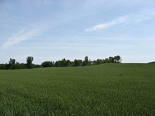
English: Western side of the
Zimmerman Kame, located on the eastern side of Township Road 39 northeast of
Roundhead in far western
McDonald Township,
Hardin County,
Ohio,
United States. A
glacial kame that was quarried until the 1970s, it was a burial site for ancient Native Americans and is listed on the
National Register of Historic Places. |
||
| Date | Taken on 6 June 2009 | ||
| Source | Own work | ||
| Author | Nyttend | ||
| Permission ( Reusing this file) |
|
||
| Other versions |
 Similar scene with golden wheat Similar scene with golden wheat
 Similar scene with no wheat Similar scene with no wheat |
File history
Click on a date/time to view the file as it appeared at that time.
| Date/Time | Thumbnail | Dimensions | User | Comment | |
|---|---|---|---|---|---|
| current | 20:15, 6 June 2009 |
| 2,816 × 2,112 (1.46 MB) | Nyttend | {{Location|40|34|24.636|N|83|49|9.588|W}} {{Information |Description={{en|Western side of the {{w|Zimmerman Kame}}, located on the eastern side of Township Road 39 northeast of {{w|Roundhead, Ohio|Roundhead}} in far western {{w|McDonald Township, Hardin C |
File usage
The following pages on the English Wikipedia use this file (pages on other projects are not listed):
Metadata
Size of this preview:
800 × 600 pixels. Other resolutions:
320 × 240 pixels |
640 × 480 pixels |
1,024 × 768 pixels |
1,280 × 960 pixels |
2,560 × 1,920 pixels |
2,816 × 2,112 pixels.
Original file (2,816 × 2,112 pixels, file size: 1.46 MB, MIME type: image/jpeg)
| This is a file from the
Wikimedia Commons. Information from its
description page there is shown below. Commons is a freely licensed media file repository. You can help. |
| Camera location |
| View this and other nearby images on: OpenStreetMap |
|
|---|
| Description |
English: Western side of the
Zimmerman Kame, located on the eastern side of Township Road 39 northeast of
Roundhead in far western
McDonald Township,
Hardin County,
Ohio,
United States. A
glacial kame that was quarried until the 1970s, it was a burial site for ancient Native Americans and is listed on the
National Register of Historic Places. |
||
| Date | Taken on 6 June 2009 | ||
| Source | Own work | ||
| Author | Nyttend | ||
| Permission ( Reusing this file) |
|
||
| Other versions |
Similar scene with golden wheat
Similar scene with no wheat |
File history
Click on a date/time to view the file as it appeared at that time.
| Date/Time | Thumbnail | Dimensions | User | Comment | |
|---|---|---|---|---|---|
| current | 20:15, 6 June 2009 |
| 2,816 × 2,112 (1.46 MB) | Nyttend | {{Location|40|34|24.636|N|83|49|9.588|W}} {{Information |Description={{en|Western side of the {{w|Zimmerman Kame}}, located on the eastern side of Township Road 39 northeast of {{w|Roundhead, Ohio|Roundhead}} in far western {{w|McDonald Township, Hardin C |
File usage
The following pages on the English Wikipedia use this file (pages on other projects are not listed):