Photos • Location


Size of this PNG preview of this SVG file:
800 × 470 pixels. Other resolutions:
320 × 188 pixels |
640 × 376 pixels |
1,024 × 601 pixels |
1,280 × 751 pixels |
2,560 × 1,503 pixels |
2,717 × 1,595 pixels.
Original file (SVG file, nominally 2,717 × 1,595 pixels, file size: 686 KB)
| This is a file from the
Wikimedia Commons. Information from its
description page there is shown below. Commons is a freely licensed media file repository. You can help. |
Summary
| Description |
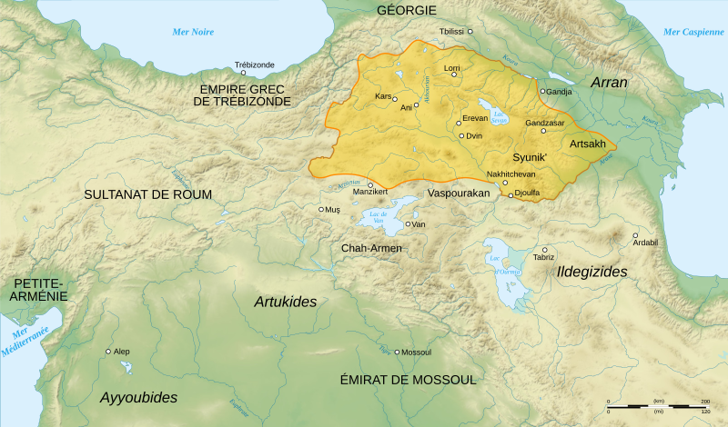
English: French map of Zakarid Armenia, around the year 1200 AD. (Source: George A. Bournoutian - «A Concise History of the Armenian People», map 19. Mazda Publishers, Inc. Costa Mesa California 2006)
Français : Carte en français de l'Arménie zakaride, vers l'an mille. |
||
| Date | |||
| Source |
Own work. Sources :
Logiciels utilisés :
Autres données :
|
||
| Author | Sémhur | ||
| Other versions | |||
| Attribution ( required by the license) | © Sémhur / Wikimedia Commons / | ||
| SVG | W3C-validity not checked.
|
||
| Graphic Lab |

| Camera location | | View this and other nearby images on: OpenStreetMap |
|
|---|
Licensing
I, the copyright holder of this work, hereby publish it under the following licenses:
| Copyleft: This work of art is free; you can redistribute it and/or modify it according to terms of the Free Art License. You will find a specimen of this license on the Copyleft Attitude site as well as on other sites. |
This file is licensed under the
Creative Commons Attribution-Share Alike
4.0 International,
3.0 Unported,
2.5 Generic,
2.0 Generic and
1.0 Generic license.
- You are free:
- to share – to copy, distribute and transmit the work
- to remix – to adapt the work
- Under the following conditions:
- attribution – You must give appropriate credit, provide a link to the license, and indicate if changes were made. You may do so in any reasonable manner, but not in any way that suggests the licensor endorses you or your use.
- share alike – If you remix, transform, or build upon the material, you must distribute your contributions under the same or compatible license as the original.
You may select the license of your choice.
File history
Click on a date/time to view the file as it appeared at that time.
| Date/Time | Thumbnail | Dimensions | User | Comment | |
|---|---|---|---|---|---|
| current | 00:24, 20 December 2015 |
| 2,717 × 1,595 (686 KB) | Geagea | Reverted to version as of 18:22, 3 August 2008 (UTC). Please upload the file with a new filename. Also see COM:OVERWRITE |
| 16:48, 19 December 2015 |
 | 2,717 × 1,595 (640 KB) | Ercwlff | Zakarid Armenia was not an independent kingdom and it had to be shown here | |
| 16:19, 18 December 2015 |
 | 2,717 × 1,595 (686 KB) | Denniss | Reverted to version as of 18:22, 3 August 2008 (UTC) - map is tagged/named as having french language, please upload under new name | |
| 14:55, 18 December 2015 |
 | 2,717 × 1,595 (728 KB) | Georgiano | translated into English. it's looks more historically accurate now | |
| 18:22, 3 August 2008 |
 | 2,717 × 1,595 (686 KB) | Sémhur | Typography | |
| 16:19, 3 August 2008 |
 | 2,717 × 1,595 (687 KB) | Sémhur | == Description == {{Information |Description= {{en| French map of Zakarid Armenia, around the year 1200 AD.}} {{fr| Carte en français de l'Arménie zakaride, vers l'an mille.}} |Source=Travail personnel. Sources : * Fond de carte : [http://www2.jpl.nasa. |
File usage
The following pages on the English Wikipedia use this file (pages on other projects are not listed):
Global file usage
The following other wikis use this file:
- Usage on avk.wikipedia.org
- Usage on azb.wikipedia.org
- Usage on ca.wikipedia.org
- Usage on cs.wikipedia.org
- Usage on el.wikipedia.org
- Usage on eo.wikipedia.org
- Usage on fa.wikipedia.org
- Usage on fr.wikipedia.org
- Noravank
- Horomos
- Chronologie de l'Arménie
- Wikipédia:Lumière sur/Mars 2009
- Mkhargrdzéli-Zachariades
- Wikipédia:Atelier graphique/Cartes/Archives/août 2008
- Arménie zakaride
- Wikipédia:Sélection/Arménie
- Wikipédia:Lumière sur/Arménie zakaride
- Miniature arménienne
- Wikipédia:Sélection/Géorgie (pays)
- Portail:Asie/Lumière sur…/Bons articles
- Wikipédia:Lumière sur/Avril 2022
- Usage on hr.wikipedia.org
- Usage on hy.wikipedia.org
- Usage on hyw.wikipedia.org
- Usage on it.wikipedia.org
- Usage on ka.wikipedia.org
- Usage on ko.wikipedia.org
- Usage on nl.wikipedia.org
- Usage on ru.wikipedia.org
View more global usage of this file.
Metadata
Size of this PNG preview of this SVG file:
800 × 470 pixels. Other resolutions:
320 × 188 pixels |
640 × 376 pixels |
1,024 × 601 pixels |
1,280 × 751 pixels |
2,560 × 1,503 pixels |
2,717 × 1,595 pixels.
Original file (SVG file, nominally 2,717 × 1,595 pixels, file size: 686 KB)
| This is a file from the
Wikimedia Commons. Information from its
description page there is shown below. Commons is a freely licensed media file repository. You can help. |
Summary
| Description |
English: French map of Zakarid Armenia, around the year 1200 AD. (Source: George A. Bournoutian - «A Concise History of the Armenian People», map 19. Mazda Publishers, Inc. Costa Mesa California 2006)
Français : Carte en français de l'Arménie zakaride, vers l'an mille. |
||
| Date | |||
| Source |
Own work. Sources :
Logiciels utilisés :
Autres données :
|
||
| Author | Sémhur | ||
| Other versions | |||
| Attribution ( required by the license) | © Sémhur / Wikimedia Commons / | ||
| SVG | W3C-validity not checked.
|
||
| Graphic Lab |
| Camera location | | View this and other nearby images on: OpenStreetMap |
|
|---|
Licensing
I, the copyright holder of this work, hereby publish it under the following licenses:
| Copyleft: This work of art is free; you can redistribute it and/or modify it according to terms of the Free Art License. You will find a specimen of this license on the Copyleft Attitude site as well as on other sites. |
This file is licensed under the
Creative Commons Attribution-Share Alike
4.0 International,
3.0 Unported,
2.5 Generic,
2.0 Generic and
1.0 Generic license.
- You are free:
- to share – to copy, distribute and transmit the work
- to remix – to adapt the work
- Under the following conditions:
- attribution – You must give appropriate credit, provide a link to the license, and indicate if changes were made. You may do so in any reasonable manner, but not in any way that suggests the licensor endorses you or your use.
- share alike – If you remix, transform, or build upon the material, you must distribute your contributions under the same or compatible license as the original.
You may select the license of your choice.
File history
Click on a date/time to view the file as it appeared at that time.
| Date/Time | Thumbnail | Dimensions | User | Comment | |
|---|---|---|---|---|---|
| current | 00:24, 20 December 2015 |
| 2,717 × 1,595 (686 KB) | Geagea | Reverted to version as of 18:22, 3 August 2008 (UTC). Please upload the file with a new filename. Also see COM:OVERWRITE |
| 16:48, 19 December 2015 |
| 2,717 × 1,595 (640 KB) | Ercwlff | Zakarid Armenia was not an independent kingdom and it had to be shown here | |
| 16:19, 18 December 2015 |
| 2,717 × 1,595 (686 KB) | Denniss | Reverted to version as of 18:22, 3 August 2008 (UTC) - map is tagged/named as having french language, please upload under new name | |
| 14:55, 18 December 2015 |
| 2,717 × 1,595 (728 KB) | Georgiano | translated into English. it's looks more historically accurate now | |
| 18:22, 3 August 2008 |
| 2,717 × 1,595 (686 KB) | Sémhur | Typography | |
| 16:19, 3 August 2008 |
| 2,717 × 1,595 (687 KB) | Sémhur | == Description == {{Information |Description= {{en| French map of Zakarid Armenia, around the year 1200 AD.}} {{fr| Carte en français de l'Arménie zakaride, vers l'an mille.}} |Source=Travail personnel. Sources : * Fond de carte : [http://www2.jpl.nasa. |
File usage
The following pages on the English Wikipedia use this file (pages on other projects are not listed):
Global file usage
The following other wikis use this file:
- Usage on avk.wikipedia.org
- Usage on azb.wikipedia.org
- Usage on ca.wikipedia.org
- Usage on cs.wikipedia.org
- Usage on el.wikipedia.org
- Usage on eo.wikipedia.org
- Usage on fa.wikipedia.org
- Usage on fr.wikipedia.org
- Noravank
- Horomos
- Chronologie de l'Arménie
- Wikipédia:Lumière sur/Mars 2009
- Mkhargrdzéli-Zachariades
- Wikipédia:Atelier graphique/Cartes/Archives/août 2008
- Arménie zakaride
- Wikipédia:Sélection/Arménie
- Wikipédia:Lumière sur/Arménie zakaride
- Miniature arménienne
- Wikipédia:Sélection/Géorgie (pays)
- Portail:Asie/Lumière sur…/Bons articles
- Wikipédia:Lumière sur/Avril 2022
- Usage on hr.wikipedia.org
- Usage on hy.wikipedia.org
- Usage on hyw.wikipedia.org
- Usage on it.wikipedia.org
- Usage on ka.wikipedia.org
- Usage on ko.wikipedia.org
- Usage on nl.wikipedia.org
- Usage on ru.wikipedia.org
View more global usage of this file.