Size of this preview:
643 × 599 pixels. Other resolutions:
258 × 240 pixels |
515 × 480 pixels |
824 × 768 pixels |
1,099 × 1,024 pixels |
2,416 × 2,252 pixels.
Original file (2,416 × 2,252 pixels, file size: 970 KB, MIME type: image/jpeg)
| This is a file from the
Wikimedia Commons. Information from its
description page there is shown below. Commons is a freely licensed media file repository. You can help. |

|
This historical map image could be re-created using
vector graphics as an
SVG file. This has several advantages; see
Commons:Media for cleanup for more information. If an SVG form of this image is available, please upload it and afterwards replace this template with
{{
vector version available|new image name}}
.
It is recommended to name the SVG file “Yugoslavia Ethnic 1940.svg”—then the template Vector version available (or Vva) does not need the new image name parameter. |


Summary
| Description |
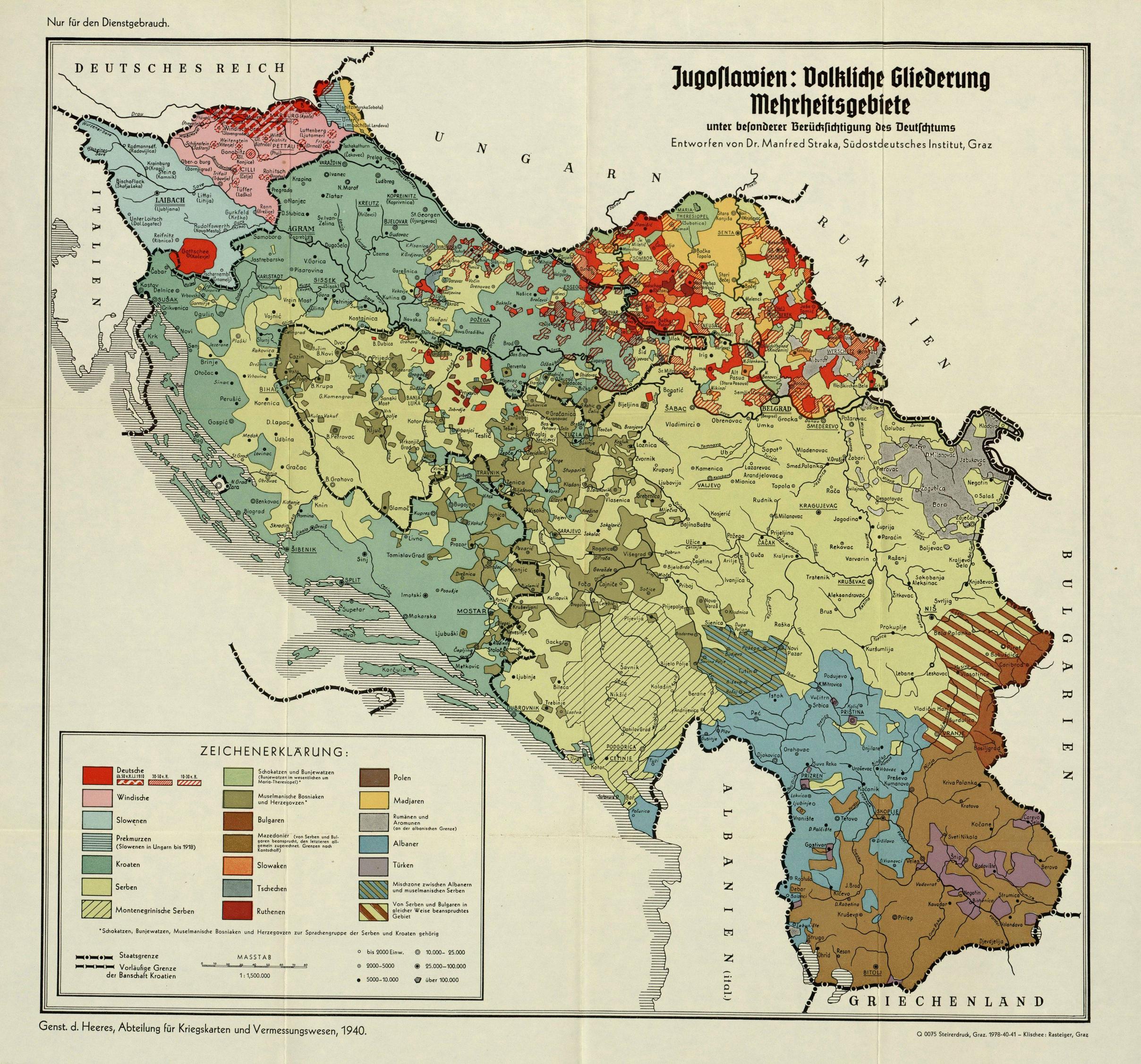
English: Ethnic Map of Kingdom of Yugoslavia, 1940 |
| Date | |
| Source | http://geographie.ipt.univ-paris8.fr/rubriks/carto/cartorub/cartes/cartesnum/34957.jpg |
| Author | Generalstab des Heeres, Abteilung für Kriegskarten und Vermessungswesen; Dr. Manfred Straka (1911-1990), Südostdeutsches Institut Graz |
Licensing
This work is an
Ordnance Survey map over 50 years old, which is covered by
Crown Copyright which in this case expires 50 years after publication. Ordnance Survey does however ask that they be credited and that the date of publication be given.
Any ancillary rights gained through the creation of the electronic version are granted as freely usable under any circumstances.
|
This work
created by the United Kingdom Government is in the
public domain.
This is because it is one of the following:
HMSO has declared that the expiry of Crown Copyrights applies worldwide (ref:
HMSO Email Reply)
|
 |
File history
Click on a date/time to view the file as it appeared at that time.
| Date/Time | Thumbnail | Dimensions | User | Comment | |
|---|---|---|---|---|---|
| current | 17:13, 14 April 2017 |
| 2,416 × 2,252 (970 KB) | Bojovnik | User created page with UploadWizard |
File usage
The following pages on the English Wikipedia use this file (pages on other projects are not listed):
Global file usage
The following other wikis use this file:
- Usage on bg.wikipedia.org
- Usage on de.wikipedia.org
- Usage on fa.wikipedia.org
- Usage on fr.wikipedia.org
- Usage on mk.wikipedia.org
- Usage on pt.wikipedia.org
- Usage on sl.wikipedia.org
- Usage on sq.wikipedia.org
- Usage on sr.wikipedia.org
- Usage on uk.wikipedia.org
- Usage on zh.wikipedia.org
Size of this preview:
643 × 599 pixels. Other resolutions:
258 × 240 pixels |
515 × 480 pixels |
824 × 768 pixels |
1,099 × 1,024 pixels |
2,416 × 2,252 pixels.
Original file (2,416 × 2,252 pixels, file size: 970 KB, MIME type: image/jpeg)
| This is a file from the
Wikimedia Commons. Information from its
description page there is shown below. Commons is a freely licensed media file repository. You can help. |
|
|
This historical map image could be re-created using
vector graphics as an
SVG file. This has several advantages; see
Commons:Media for cleanup for more information. If an SVG form of this image is available, please upload it and afterwards replace this template with
{{
vector version available|new image name}}
.
It is recommended to name the SVG file “Yugoslavia Ethnic 1940.svg”—then the template Vector version available (or Vva) does not need the new image name parameter. |
Summary
| Description |
English: Ethnic Map of Kingdom of Yugoslavia, 1940 |
| Date | |
| Source | http://geographie.ipt.univ-paris8.fr/rubriks/carto/cartorub/cartes/cartesnum/34957.jpg |
| Author | Generalstab des Heeres, Abteilung für Kriegskarten und Vermessungswesen; Dr. Manfred Straka (1911-1990), Südostdeutsches Institut Graz |
Licensing
This work is an
Ordnance Survey map over 50 years old, which is covered by
Crown Copyright which in this case expires 50 years after publication. Ordnance Survey does however ask that they be credited and that the date of publication be given.
Any ancillary rights gained through the creation of the electronic version are granted as freely usable under any circumstances.
|
This work
created by the United Kingdom Government is in the
public domain.
This is because it is one of the following:
HMSO has declared that the expiry of Crown Copyrights applies worldwide (ref:
HMSO Email Reply)
|
|
File history
Click on a date/time to view the file as it appeared at that time.
| Date/Time | Thumbnail | Dimensions | User | Comment | |
|---|---|---|---|---|---|
| current | 17:13, 14 April 2017 |
| 2,416 × 2,252 (970 KB) | Bojovnik | User created page with UploadWizard |
File usage
The following pages on the English Wikipedia use this file (pages on other projects are not listed):
Global file usage
The following other wikis use this file:
- Usage on bg.wikipedia.org
- Usage on de.wikipedia.org
- Usage on fa.wikipedia.org
- Usage on fr.wikipedia.org
- Usage on mk.wikipedia.org
- Usage on pt.wikipedia.org
- Usage on sl.wikipedia.org
- Usage on sq.wikipedia.org
- Usage on sr.wikipedia.org
- Usage on uk.wikipedia.org
- Usage on zh.wikipedia.org