Size of this preview:
450 × 599 pixels. Other resolutions:
180 × 240 pixels |
360 × 480 pixels |
577 × 768 pixels |
769 × 1,024 pixels |
1,538 × 2,048 pixels |
3,756 × 5,000 pixels.
Original file (3,756 × 5,000 pixels, file size: 3.15 MB, MIME type: image/jpeg)
| This is a file from the
Wikimedia Commons. Information from its
description page there is shown below. Commons is a freely licensed media file repository. You can help. |
| Description |
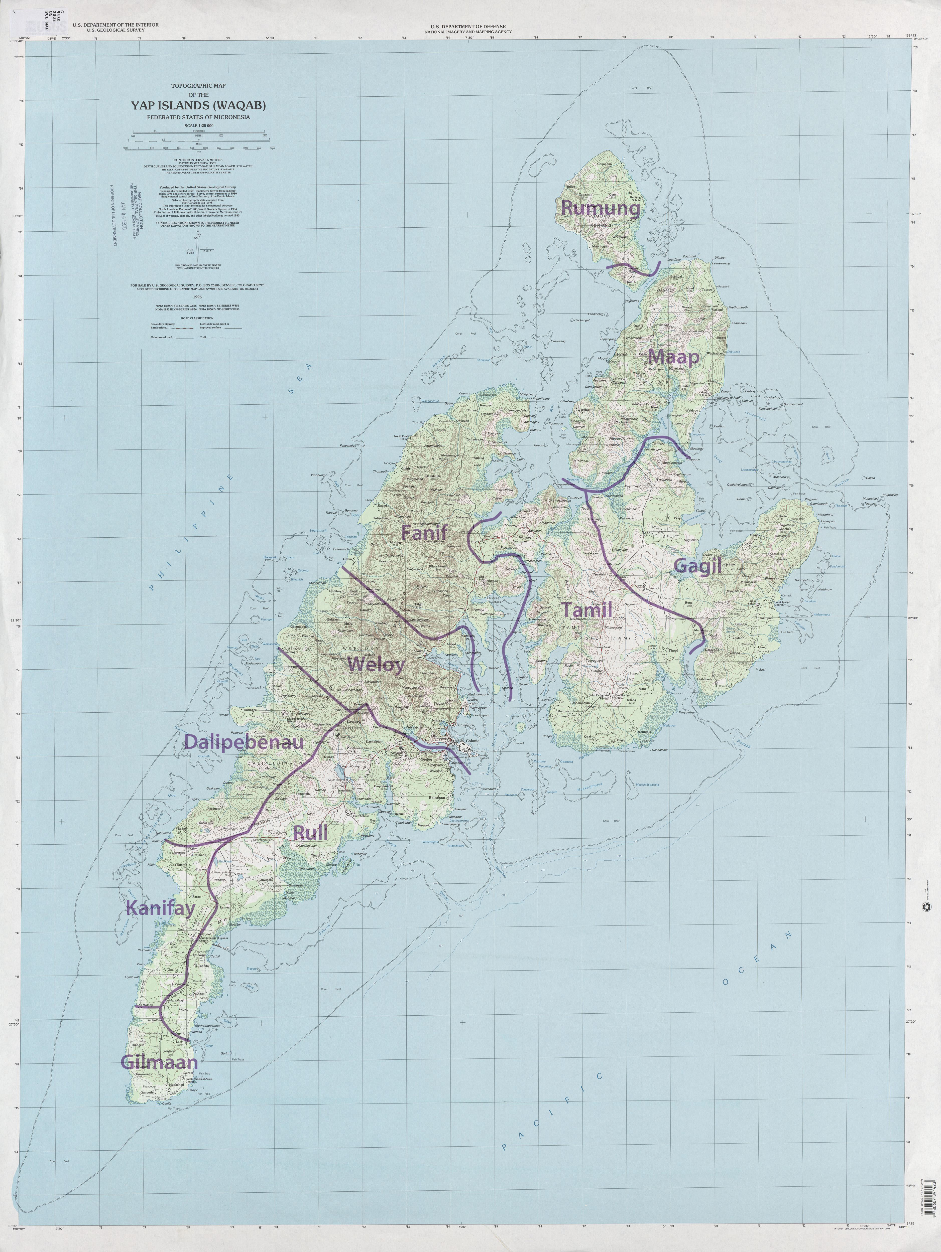
Deutsch: Yap-Inseln (Föderierte Staaten von Mikronesien) mit Gemeindegrenzen
English: Yap Islands (Federated States of Micronesia) with municipality boundaries |
| Date | (UTC) |
| Source | |
| Author |
|
| This is a
retouched picture, which means that it has been digitally altered from its original version. Modifications: municipalities added. The original can be viewed here:
Txu-oclc-0607891424-yap island.jpg:
|
This image is in the
public domain in the United States because it only contains materials that originally came from the
United States Geological Survey, an agency of the
United States Department of the Interior. For more information, see
the official USGS copyright policy.
|
Original upload log
This image is a derivative work of the following images:
-
File:Txu-oclc-0607891424-yap_island.jpg licensed with PD-USGov-USGS
- 2010-01-08T21:26:47Z Ratzer1 3756x5000 (2748638 Bytes) {{Information |Description={{en|1=detailed topographic map of Yap Islands, Federated States of Micronesia, Pacific Ocean}} |Source=http://www.lib.utexas.edu/maps/topo/pacific_islands/txu-oclc-0607891424-yap_island.jpg |Author
Uploaded with derivativeFX
File history
Click on a date/time to view the file as it appeared at that time.
| Date/Time | Thumbnail | Dimensions | User | Comment | |
|---|---|---|---|---|---|
| current | 09:38, 17 May 2010 |
| 3,756 × 5,000 (3.15 MB) | NordNordWest | {{Information |Description={{de|1=Yap-Inseln (Föderierte Staaten von Mikronesien) mit Gemeindegrenzen}} {{en|1=Yap Islands (Federated States of Micronesia) with municipality boundaries}} |Source=* File:Txu-oclc-0607891424-yap_island.jpg |Date=2010-0 |
File usage
The following pages on the English Wikipedia use this file (pages on other projects are not listed):
Global file usage
The following other wikis use this file:
- Usage on ca.wikipedia.org
- Usage on de.wikipedia.org
- Usage on es.wikipedia.org
- Usage on fa.wikipedia.org
- Usage on gl.wikipedia.org
- Usage on id.wikipedia.org
- Usage on it.wikipedia.org
- Usage on ka.wikipedia.org
- Usage on lt.wikipedia.org
- Usage on ru.wikipedia.org
- Usage on uk.wikipedia.org
- Usage on vi.wikipedia.org
Metadata
Size of this preview:
450 × 599 pixels. Other resolutions:
180 × 240 pixels |
360 × 480 pixels |
577 × 768 pixels |
769 × 1,024 pixels |
1,538 × 2,048 pixels |
3,756 × 5,000 pixels.
Original file (3,756 × 5,000 pixels, file size: 3.15 MB, MIME type: image/jpeg)
| This is a file from the
Wikimedia Commons. Information from its
description page there is shown below. Commons is a freely licensed media file repository. You can help. |
| Description |
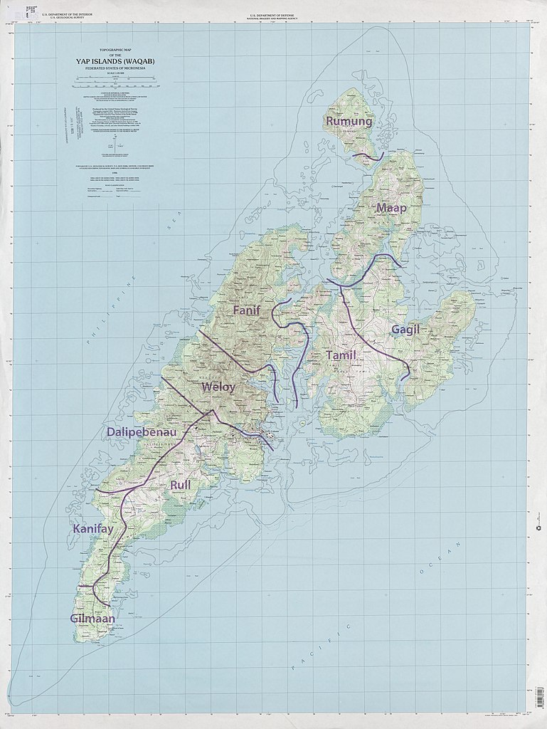
Deutsch: Yap-Inseln (Föderierte Staaten von Mikronesien) mit Gemeindegrenzen
English: Yap Islands (Federated States of Micronesia) with municipality boundaries |
| Date | (UTC) |
| Source | |
| Author |
|
| This is a
retouched picture, which means that it has been digitally altered from its original version. Modifications: municipalities added. The original can be viewed here:
Txu-oclc-0607891424-yap island.jpg:
|
This image is in the
public domain in the United States because it only contains materials that originally came from the
United States Geological Survey, an agency of the
United States Department of the Interior. For more information, see
the official USGS copyright policy.
|
Original upload log
This image is a derivative work of the following images:
-
File:Txu-oclc-0607891424-yap_island.jpg licensed with PD-USGov-USGS
- 2010-01-08T21:26:47Z Ratzer1 3756x5000 (2748638 Bytes) {{Information |Description={{en|1=detailed topographic map of Yap Islands, Federated States of Micronesia, Pacific Ocean}} |Source=http://www.lib.utexas.edu/maps/topo/pacific_islands/txu-oclc-0607891424-yap_island.jpg |Author
Uploaded with derivativeFX
File history
Click on a date/time to view the file as it appeared at that time.
| Date/Time | Thumbnail | Dimensions | User | Comment | |
|---|---|---|---|---|---|
| current | 09:38, 17 May 2010 |
| 3,756 × 5,000 (3.15 MB) | NordNordWest | {{Information |Description={{de|1=Yap-Inseln (Föderierte Staaten von Mikronesien) mit Gemeindegrenzen}} {{en|1=Yap Islands (Federated States of Micronesia) with municipality boundaries}} |Source=* File:Txu-oclc-0607891424-yap_island.jpg |Date=2010-0 |
File usage
The following pages on the English Wikipedia use this file (pages on other projects are not listed):
Global file usage
The following other wikis use this file:
- Usage on ca.wikipedia.org
- Usage on de.wikipedia.org
- Usage on es.wikipedia.org
- Usage on fa.wikipedia.org
- Usage on gl.wikipedia.org
- Usage on id.wikipedia.org
- Usage on it.wikipedia.org
- Usage on ka.wikipedia.org
- Usage on lt.wikipedia.org
- Usage on ru.wikipedia.org
- Usage on uk.wikipedia.org
- Usage on vi.wikipedia.org